Mysterious Ancient Cultures and Archaeological Sites
Chapter 1: Introduction to Ancient Cultures and Archaeology
1.1 Understanding Archaeology: Methods and Best Practices
Archaeology is the study of human history and prehistory through the excavation and analysis of artifacts, architecture, and cultural landscapes. It combines scientific methods with careful interpretation to reconstruct past human activities. The core goal is to gather evidence about how people lived, worked, and interacted with their environment.
Key Archaeological Methods
Archaeologists use a variety of methods to locate, excavate, and analyze sites. These methods can be grouped into three main categories: survey, excavation, and analysis.
-
Survey: This initial step involves locating potential sites. Techniques include field walking, aerial photography, and remote sensing technologies like LiDAR. For example, LiDAR was instrumental in revealing hidden Maya cities beneath dense jungle canopy.
-
Excavation: Once a site is identified, excavation uncovers artifacts and features. Excavation is a careful, layer-by-layer process to preserve context. For instance, the excavation at Çatalhöyük involved meticulous removal of mudbrick layers to reveal domestic spaces without damaging fragile wall paintings.
-
Analysis: After excavation, artifacts and ecofacts are cleaned, cataloged, and studied. This includes typological classification, radiocarbon dating, and microscopic analysis. For example, pottery shards from the Indus Valley were analyzed to understand trade patterns.
Best Practices in Archaeological Work
-
Context Preservation: The position and association of artifacts matter as much as the objects themselves. Removing an artifact without recording its context is like tearing a page out of a book without noting its place.
-
Systematic Documentation: Detailed notes, photographs, and drawings are essential. At the site of Pompeii, extensive documentation has allowed researchers to study the city’s layout and daily life centuries after excavation.
-
Interdisciplinary Collaboration: Archaeology often involves specialists such as botanists, chemists, and historians. For example, pollen analysis helped clarify agricultural practices in Neolithic Europe.
-
Non-Destructive Techniques: Whenever possible, archaeologists use methods that avoid disturbing the site, such as ground-penetrating radar (GPR). This approach was used at Stonehenge to map underground features without excavation.
-
Ethical Considerations: Respecting local communities, obtaining permits, and ensuring proper artifact curation are fundamental. The repatriation of Native American artifacts under the NAGPRA law in the U.S. exemplifies ethical stewardship.
Mind Map: Archaeological Methods
Mind Map: Best Practices in Archaeology
Example: Excavation at Çatalhöyük
Çatalhöyük, a large Neolithic settlement in modern-day Turkey, illustrates best practices well. Excavators used a grid system to divide the site into manageable squares. Each layer was carefully removed and recorded. The team documented wall paintings and household items in situ before removal. Collaboration with specialists in archaeobotany and zooarchaeology helped reconstruct diet and environment. This approach ensured that the site’s complexity was preserved and understood.
Example: Use of LiDAR in Maya Archaeology
In the dense jungles of Guatemala, LiDAR scanning revealed thousands of previously unknown Maya structures. This non-invasive survey method allowed archaeologists to map entire cities without clearing vegetation. The data provided insights into urban planning and population density, demonstrating how technology can complement traditional methods.
In summary, archaeology relies on a balance of careful excavation, thorough documentation, and interdisciplinary analysis. Following best practices ensures that the evidence uncovered is reliable and meaningful, allowing us to piece together human history with clarity and respect.
1.2 Defining Ancient Cultures: Criteria and Classifications
Defining ancient cultures involves identifying shared characteristics that distinguish one group from another across time and space. These characteristics include language, social structure, technology, belief systems, and material culture. Archaeologists classify ancient cultures by examining artifacts, settlement patterns, burial customs, and written records when available.
Criteria for Defining Ancient Cultures
- Material Culture: Objects made or used by people, such as pottery, tools, and ornaments. These provide clues about daily life, technology, and trade.
- Social Organization: How a society structures itself, including leadership, class systems, and kinship.
- Language and Writing: Scripts or symbols that convey communication, laws, or religious ideas.
- Belief Systems: Religious practices, rituals, and mythologies.
- Settlement Patterns: The layout and location of dwellings, cities, and ceremonial centers.
Mind Map: Key Criteria for Defining Ancient Cultures
Classification Approaches
-
Typological Classification: Grouping cultures based on artifact styles or architectural features. For example, the distinction between Neolithic pottery styles helps identify different cultural groups in prehistoric Europe.
-
Chronological Classification: Organizing cultures by time periods, such as the Bronze Age or Iron Age, which reflect technological advances.
-
Geographical Classification: Defining cultures by their location, like the Nile Valley civilization or the Andean cultures.
-
Ethnoarchaeological Comparison: Using modern or historically documented societies to interpret ancient cultural traits.
Example: The Ancient Egyptians
- Material Culture: Distinctive pottery, jewelry, and monumental architecture like pyramids.
- Social Organization: Pharaoh-centered hierarchy with priests, scribes, and laborers.
- Language & Writing: Hieroglyphic script used for religious and administrative purposes.
- Belief Systems: Complex pantheon and elaborate funerary practices.
- Settlement Patterns: Cities along the Nile with planned layouts and necropolises.
Mind Map: Egyptian Culture Classification
Example: The Indus Valley Civilization
- Material Culture: Standardized weights, seals with animal motifs, and baked brick architecture.
- Social Organization: Evidence suggests an organized urban society but lacks clear signs of centralized rulers.
- Language & Writing: Undeciphered script found on seals.
- Belief Systems: Possible worship of fertility symbols and animals.
- Settlement Patterns: Well-planned cities like Mohenjo-Daro with grid layouts and drainage systems.
Mind Map: Indus Valley Culture Classification
These examples show how combining multiple criteria helps archaeologists define and distinguish ancient cultures. The process is iterative and relies on accumulating evidence from excavations and analyses. Clear classification aids in understanding cultural interactions, technological diffusion, and historical development.
1.3 Importance of Context in Archaeological Interpretation
Archaeological context refers to the position and association of artifacts, features, and ecofacts within the site where they are found. It is the framework that allows archaeologists to understand not just what an object is, but what it meant to the people who used it. Without context, artifacts become isolated pieces of information, losing much of their significance.
Why Context Matters
- Spatial Relationships: The location of an artifact relative to other finds can reveal patterns of use, social organization, or ritual behavior. For example, finding pottery shards clustered near hearths suggests domestic activities.
- Stratigraphy: Layers of soil and deposits indicate chronological sequences. An object found deeper in the soil is generally older than one closer to the surface, helping establish timelines.
- Association: Items found together may have been used simultaneously or related in function. A burial site with weapons and jewelry can indicate the status or role of the individual.
Mind Map: Components of Archaeological Context
Example: The Rosetta Stone
The Rosetta Stone is a famous artifact, but its significance comes largely from its context. Found in 1799 during the Napoleonic campaign in Egypt, it was part of a larger collection of stones used in the construction of a fort. Its inscriptions in three scripts—hieroglyphic, Demotic, and Greek—allowed scholars to decode Egyptian hieroglyphs. Without knowing the stone’s origin and the fact that the texts were translations of the same decree, the breakthrough in understanding ancient Egyptian writing would not have been possible.
Mind Map: Contextual Interpretation of the Rosetta Stone
Example: Pompeii’s Contextual Preservation
Pompeii’s sudden burial under volcanic ash in 79 AD preserved buildings, artifacts, and even human forms in situ. This unique context allows archaeologists to study Roman urban life with exceptional detail. The spatial arrangement of shops, homes, and public spaces, combined with the artifacts left behind, paints a clear picture of daily routines, social structures, and economic activities.
Mind Map: Pompeii’s Archaeological Context
Practical Considerations
- Recording Context: Archaeologists meticulously document the exact position and surroundings of finds. This includes photographs, drawings, and GPS coordinates.
- Avoiding Disturbance: Excavation is done carefully to preserve context. Removing an artifact without recording its position is like tearing a page from a book and expecting to understand the story.
- Interpreting Context: Context can be complex. For example, objects may be moved by later activity, natural processes, or looting. Archaeologists must consider these factors when reconstructing past behaviors.
Mind Map: Best Practices for Maintaining Context
In summary, context transforms artifacts from isolated curiosities into meaningful clues about past human life. It provides the setting that connects objects to people, places, and time, enabling archaeologists to build accurate narratives about early civilizations.
1.4 Case Study: Excavation Techniques at Çatalhöyük
Çatalhöyük, located in modern-day Turkey, is one of the most extensively studied Neolithic sites. Excavations here have provided valuable insights into early urban life, social organization, and symbolic practices. The excavation techniques used at Çatalhöyük illustrate how careful methodology can reveal complex cultural layers without losing context.
Site Layout and Excavation Approach
Çatalhöyük is characterized by densely packed mudbrick houses sharing walls, with no streets between them. This unique layout required a specialized excavation strategy to understand both individual structures and the settlement as a whole.
- Excavators used a grid system, dividing the site into squares for systematic digging.
- Vertical stratigraphy was carefully recorded to track occupation phases.
- Horizontal exposure was balanced with vertical excavation to preserve spatial relationships.
Mind Map: Excavation Strategy at Çatalhöyük
Recording and Documentation
Detailed recording was essential due to the site’s complexity. Excavators used:
- Photogrammetry and detailed drawings to capture wall paintings and architectural features.
- Context sheets to document each stratigraphic unit.
- 3D modeling to reconstruct building phases.
This comprehensive documentation allowed researchers to analyze spatial and temporal relationships accurately.
Handling Artifacts and Ecofacts
Çatalhöyük yielded a wide range of artifacts, from tools to symbolic objects. Best practices included:
- In situ preservation of fragile items like wall paintings and plaster reliefs.
- Careful sieving of soil to recover small artifacts and ecofacts such as seeds and bones.
- Use of flotation techniques to separate organic remains for environmental reconstruction.
Mind Map: Artifact Handling Techniques
Example: Excavating a Single House
When excavating an individual house, teams:
- Removed roof debris layer by layer to expose interior features.
- Recorded hearths, platforms, and burials found beneath floors.
- Noted evidence of repairs and modifications to understand usage over time.
This approach revealed that houses were not just living spaces but also places of ritual and memory.
Integration of Multidisciplinary Methods
Excavation at Çatalhöyük incorporated specialists in archaeobotany, zooarchaeology, and geoarchaeology. For example:
- Soil micromorphology helped identify activity areas within houses.
- Analysis of animal bones provided insight into diet and domestication.
- Botanical remains indicated agricultural practices and seasonal cycles.
Mind Map: Multidisciplinary Integration
Summary
The excavation techniques at Çatalhöyük demonstrate the importance of combining precise stratigraphic control, thorough documentation, careful artifact handling, and multidisciplinary collaboration. These practices have allowed archaeologists to build a detailed picture of life in one of the earliest large settlements, showing how methodical excavation can reveal the complexity of ancient societies.
1.5 Ethical Considerations in Archaeological Research
Ethical considerations in archaeological research are fundamental to ensuring respect for the past, present communities, and the scientific integrity of the field. Archaeologists must balance the pursuit of knowledge with responsibilities toward cultural heritage, descendant communities, and legal frameworks. This section outlines key ethical principles, illustrated with examples and organized through mind maps to clarify their relationships.
Respect for Cultural Heritage
Archaeological sites and artifacts are non-renewable resources. Excavating or studying them requires care to avoid unnecessary destruction. Respect means treating sites as more than just data points; they are remnants of human history with ongoing cultural significance.
- Example: The excavation of Native American burial sites in the United States is governed by laws like NAGPRA (Native American Graves Protection and Repatriation Act), which mandates consultation with descendant communities before any disturbance.
Collaboration with Descendant and Local Communities
Engaging with communities connected to archaeological sites ensures research is culturally sensitive and socially responsible. This collaboration can influence research questions, excavation methods, and the handling of finds.
- Example: In Australia, archaeologists working on Aboriginal sites often partner with elders to understand the cultural context, ensuring that sacred sites are not disturbed and that findings are interpreted respectfully.
Legal Compliance and Permits
Archaeologists must operate within the legal frameworks of the countries where they work. This includes obtaining permits, respecting ownership rights, and adhering to international conventions on cultural property.
- Example: The UNESCO 1970 Convention aims to prevent illicit trafficking of cultural property. Archaeologists must ensure that artifacts are documented and remain within their country of origin unless legally exported.
Avoidance of Looting and Illicit Trade
Ethical research actively opposes the looting of sites and the black market trade of artifacts. Archaeologists contribute by documenting finds thoroughly and advocating for site protection.
- Example: The looting of Mesopotamian sites during conflicts has led to significant losses of cultural heritage. Ethical archaeologists work with governments and organizations to monitor and protect vulnerable sites.
Transparency and Data Sharing
Sharing data openly with the academic community and, where appropriate, the public fosters trust and advances knowledge. However, sensitive information, such as the location of fragile sites, may be withheld to prevent damage.
- Example: The publication of excavation reports from Pompeii includes detailed findings but omits precise coordinates to discourage unauthorized digging.
Preservation vs. Excavation
Deciding when to excavate is an ethical question. Excavation is inherently destructive; once a site is excavated, it cannot be undone. Sometimes, leaving a site untouched and preserving it in situ is the best choice.
- Example: Archaeologists at Çatalhöyük have opted for limited excavation combined with extensive non-invasive surveys to preserve large portions of the site for future research.
Mind Map: Core Ethical Principles in Archaeological Research
Case Study: The Kennewick Man Controversy
The discovery of ancient human remains in Washington State sparked debates over scientific study versus indigenous rights. The remains were initially studied for their anthropological value but were later claimed by Native American tribes for reburial under NAGPRA. This case highlights the tension between research interests and cultural respect.
Mind Map: Stakeholders in Ethical Archaeology
Ethical Decision-Making Framework
When faced with ethical dilemmas, archaeologists can follow a structured approach:
- Identify all stakeholders and their interests.
- Assess legal requirements and cultural sensitivities.
- Evaluate potential impacts of research actions.
- Seek input from relevant communities.
- Choose actions that minimize harm and maximize respect.
- Document decisions and rationales transparently.
- Example: Before excavating a newly discovered burial site, archaeologists consult local communities, review legal frameworks, and consider non-invasive methods. If excavation proceeds, they ensure proper handling and eventual reburial if requested.
Summary
Ethical considerations in archaeology are not just guidelines but essential practices that shape responsible research. They ensure that the past is studied with respect for those connected to it today and protect cultural heritage for future generations. Integrating these principles into everyday archaeological work requires awareness, communication, and a commitment to balancing knowledge with respect.
Chapter 2: The Indus Valley Civilization – Urban Planning and Social Organization
2.1 Overview of the Indus Valley Civilization
The Indus Valley Civilization (IVC), also known as the Harappan Civilization, was one of the world’s earliest urban cultures, flourishing approximately between 3300 BCE and 1300 BCE in what is now Pakistan and northwest India. It covered a vast area along the Indus River and its tributaries, making it one of the largest Bronze Age civilizations. The civilization is notable for its advanced city planning, standardized weights and measures, and undeciphered script.
Key Features of the Indus Valley Civilization
- Urban Centers: Major cities like Harappa and Mohenjo-Daro featured grid layouts, sophisticated drainage systems, and large public baths.
- Economy: Based on agriculture, trade, and craft specialization, with evidence of long-distance trade with Mesopotamia.
- Social Organization: While no clear evidence of kings or temples has been found, the uniformity in urban planning suggests a centralized authority or shared cultural norms.
- Writing System: The Indus script remains undeciphered, consisting of short inscriptions on seals and pottery.
Mind Map: Indus Valley Civilization Overview
Urban Planning and Architecture
Cities like Mohenjo-Daro were laid out in a grid pattern with streets intersecting at right angles. Houses were built from standardized baked bricks, often with multiple rooms and courtyards. The presence of an advanced drainage system, including covered drains along major streets, indicates a concern for sanitation and public health.
Example: The Great Bath of Mohenjo-Daro
One of the most famous structures is the Great Bath, a large watertight pool surrounded by steps and rooms. It likely served a ritual or communal purpose, showing the importance of water in their culture. The bath’s construction used tightly fitted bricks and a layer of bitumen to prevent leakage, demonstrating engineering skill.
Economy and Trade
Agriculture formed the economic base, with wheat, barley, peas, and cotton cultivated. Artisans produced pottery, beads, and metal goods. Standardized weights and measures found across sites suggest regulated trade practices. Evidence of trade with Mesopotamia includes Indus seals found in Mesopotamian cities and Mesopotamian items in Indus sites.
Mind Map: Economy and Trade
Social Structure and Governance
The lack of palaces or grand tombs suggests a society without a dominant monarchy or priestly class, or at least one that left little architectural trace. The uniformity in city layouts and artifact styles points to shared cultural or administrative systems. Some scholars propose a form of collective governance or a bureaucratic system.
Writing and Seals
The Indus script appears on seals, pottery, and other objects, typically consisting of brief inscriptions accompanied by animal motifs. Despite many attempts, the script remains undeciphered due to the short length of inscriptions and lack of bilingual texts. The seals likely served administrative or trade functions.
Mind Map: Writing System
In summary, the Indus Valley Civilization was a complex and well-organized society marked by urban sophistication, economic regulation, and cultural uniformity. Its mysteries, such as the undeciphered script and unclear governance structures, continue to challenge archaeologists and historians.
2.2 Best Practices in Excavating Urban Sites: Mohenjo-Daro Example
Excavating urban sites like Mohenjo-Daro requires a careful balance between systematic methodology and adaptability to the unique challenges posed by dense, complex remains. Mohenjo-Daro, one of the largest settlements of the Indus Valley Civilization, offers a textbook example of urban archaeology that demands precision and patience.
Planning and Surveying
Before any digging begins, a detailed survey is essential. At Mohenjo-Daro, archaeologists used grid systems to divide the site into manageable squares. This approach helps maintain spatial control and ensures that every artifact and feature is recorded with exact coordinates.
Mind Map: Excavation Planning
Stratigraphic Excavation
Urban sites often have multiple occupation layers. At Mohenjo-Daro, stratigraphy was critical for distinguishing phases of construction and use. Excavators carefully removed soil layer by layer, documenting changes in material culture and architecture.
This method prevents mixing artifacts from different periods, which could lead to inaccurate interpretations. For example, distinguishing between an earlier mudbrick wall and a later stone structure helps trace the city’s development.
Contextual Recording
Every find at Mohenjo-Daro was recorded with its precise location and depth. Context is king in archaeology; a pot shard alone tells little, but knowing it was found near a drainage channel adds meaning.
Photographs, drawings, and written notes were combined to create a comprehensive record. This documentation allows researchers to reconstruct the urban environment and understand how spaces were used.
Conservation On-Site
Mohenjo-Daro’s mudbrick structures are vulnerable to weathering. Excavators implemented immediate conservation measures, such as sheltering exposed walls and stabilizing fragile features. This practice prevents deterioration during and after excavation.
Interdisciplinary Collaboration
Excavation teams at Mohenjo-Daro included specialists in ceramics, bioarchaeology, and geoarchaeology. For example, soil analysis helped identify ancient sewage systems, while ceramic experts classified pottery styles to date layers.
Mind Map: Interdisciplinary Approach
Example: Excavation of the Great Bath
The Great Bath is a large, watertight pool believed to have had ritual significance. Excavators carefully removed surrounding soil to expose its elaborate brickwork and drainage channels. They documented the construction details and preserved the fragile bricks by applying consolidants.
Practical Tips from Mohenjo-Daro Excavations
- Use a grid system to maintain spatial control.
- Excavate in stratigraphic layers to preserve chronological integrity.
- Record context meticulously with multiple documentation methods.
- Implement immediate conservation to protect delicate materials.
- Engage specialists early to interpret complex finds.
Mind Map: Best Practices Summary
These practices, demonstrated at Mohenjo-Daro, provide a framework for excavating urban archaeological sites effectively and responsibly.
2.3 Understanding Ancient Sanitation Systems: Practical Insights
Sanitation systems are often overlooked in discussions about ancient civilizations, yet they reveal much about a society’s priorities, technological skills, and daily life. Ancient sanitation was not just about waste disposal; it was a complex intersection of engineering, public health, and social organization.
The Basics of Ancient Sanitation
Sanitation systems in ancient times primarily dealt with the management of human waste, drainage of stormwater, and clean water supply. These systems helped prevent disease, maintain urban hygiene, and support dense populations.
Key components:
- Toilets and latrines: Places designated for waste collection.
- Drainage channels: Systems to carry waste and rainwater away.
- Sewers: Underground conduits for waste transport.
- Water supply: Wells, aqueducts, or pipes delivering clean water.
Mind Map: Components of Ancient Sanitation Systems
Case Study: Mohenjo-Daro’s Sanitation
Mohenjo-Daro, one of the major cities of the Indus Valley Civilization (c. 2500 BCE), provides one of the earliest examples of an advanced sanitation system.
- Private Bathrooms: Many houses had private bathrooms connected to covered drains running beneath streets.
- Drainage Network: The drains were made of brick and covered with stone slabs, designed to carry wastewater out of the city.
- Waste Disposal: Wastewater was channeled into soak pits or communal cesspits.
This system shows a clear understanding of hygiene and urban planning. The presence of such infrastructure indicates coordinated civic management and concern for public health.
Mind Map: Mohenjo-Daro Sanitation Features
Example: Roman Sanitation Systems
The Romans took sanitation to another level with their public baths, latrines, and extensive sewer systems.
- Cloaca Maxima: One of the world’s earliest sewage systems, it drained waste into the Tiber River.
- Public Latrines: Large communal toilets with running water underneath to carry waste away.
- Aqueducts: Delivered fresh water to cities, supporting sanitation and public baths.
Romans understood that sanitation was essential for urban life and invested in durable infrastructure.
Mind Map: Roman Sanitation Infrastructure
Materials and Construction Techniques
Ancient sanitation systems used locally available materials:
- Stone and Brick: Durable and resistant to water, used for drains and sewers.
- Clay Pipes: Common in Indus Valley and Roman systems for waste transport.
- Wood: Sometimes used but less durable and prone to decay.
Construction techniques included sloping drains for gravity flow, covered channels to prevent blockages and odors, and regular maintenance access points.
Social and Cultural Dimensions
Sanitation was not just technical; it reflected social norms.
- Public vs. Private: Some societies emphasized private latrines (Indus Valley), while others had communal facilities (Romans).
- Labor: Maintenance often required organized labor, sometimes involving lower social classes.
- Religious and Cultural Beliefs: Cleanliness had spiritual significance in many cultures, influencing sanitation design.
Example: Sanitation in Ancient Japan
The Yayoi period (c. 300 BCE–300 CE) in Japan shows early use of pit latrines and drainage ditches, reflecting a practical approach to waste management in rural settlements.
Mind Map: Social Aspects of Ancient Sanitation
Summary
Understanding ancient sanitation systems requires looking at engineering, materials, urban planning, and social context. Examples like Mohenjo-Daro and Rome demonstrate how sanitation was integral to city life and public health. The practical insights from these systems show that ancient societies developed effective solutions tailored to their environment and culture.
This knowledge informs modern archaeology by highlighting the importance of infrastructure in interpreting ancient urbanism and social organization.
2.4 Deciphering Indus Script: Methodologies and Challenges
Deciphering the Indus script remains one of archaeology’s most persistent puzzles. The script consists of short sequences of symbols found on seals, pottery, and other artifacts from the Indus Valley Civilization (circa 2600–1900 BCE). Despite decades of study, no definitive reading has emerged. This section outlines the main methodologies used to approach the script, the challenges faced, and examples illustrating these points.
Methodologies in Deciphering the Indus Script
Frequency Analysis
Researchers start by cataloging symbols and counting their occurrences and combinations. This helps identify common signs and potential syntax patterns.
- Example: The “fish” symbol appears frequently, often at the start or end of inscriptions, suggesting it could be a determinative or a common word.
Comparative Linguistics
Scholars attempt to link the script to known languages, especially Dravidian, Indo-Aryan, or Munda languages. This involves matching symbol patterns to linguistic structures.
- Example: Some propose that the script encodes a proto-Dravidian language, based on structural similarities in sign sequences and Dravidian grammar.
Contextual Analysis
Examining the archaeological context of inscriptions helps infer their function—whether administrative, religious, or commercial.
- Example: Seals found in trading hubs suggest the inscriptions might be names or titles related to merchants or goods.
Iconographic Correlation
Some symbols resemble objects or animals, prompting hypotheses that the script is partly pictographic or ideographic.
- Example: The “unicorn” motif appears on many seals, possibly representing a clan symbol or deity.
Statistical and Computational Methods
Modern approaches use computer algorithms to detect patterns, sign clusters, and possible grammar rules.
- Example: Markov chain models have been applied to analyze sign order probabilities, revealing non-random structures.
Challenges in Decipherment
-
Short Texts: Most inscriptions are brief, averaging 5 signs, limiting contextual clues.
-
No Bilingual Text: Unlike the Rosetta Stone for Egyptian hieroglyphs, no bilingual inscription exists for the Indus script.
-
Unknown Language: The underlying language is not confirmed, complicating linguistic comparison.
-
Symbol Ambiguity: Some signs may represent sounds, words, or concepts, but their exact function is unclear.
-
Lack of Continuity: The script fell out of use, leaving no direct descendants or related scripts.
Mind Map: Deciphering Indus Script Methodologies
Mind Map: Challenges in Decipherment
Example: Frequency Analysis in Practice
Researchers compiled a corpus of over 4,000 inscriptions, identifying approximately 400 distinct signs. They noted that some signs appear almost exclusively at the beginning or end of inscriptions, hinting at possible grammatical roles such as prefixes or suffixes. For instance, the “jar” symbol often appears at the end, which might indicate a word ending or a marker.
Example: Computational Approach
A team applied entropy measures to the sign sequences, finding that the script’s structure is more ordered than random symbol strings but less complex than fully developed writing systems. This suggests the script could be logo-syllabic or a proto-writing system.
In summary, the Indus script’s decipherment involves combining linguistic, archaeological, and computational tools. Each method sheds light on different aspects but also faces significant hurdles. The brevity of texts and absence of a known language or bilingual key remain the main obstacles. Nonetheless, systematic analysis continues to refine our understanding of this enigmatic script.
2.5 Social Hierarchies and Trade Networks: Archaeological Evidence
The Indus Valley Civilization (IVC) presents a complex picture of social hierarchies and trade networks, primarily through the archaeological evidence uncovered at sites such as Harappa and Mohenjo-Daro. Unlike some ancient cultures with clear markers of elite classes, the IVC’s social structure appears more subtle, inferred through material culture and urban layout rather than monumental palaces or grand tombs.
Social Hierarchies
Archaeologists identify social stratification in the Indus Valley through variations in housing size, craftsmanship, and burial practices. Larger, well-constructed houses with multiple rooms and private wells suggest wealthier inhabitants, possibly merchants or administrators. Smaller, simpler dwellings likely housed laborers or artisans.
Artifacts such as seals, often found in administrative contexts, indicate a class involved in record-keeping and trade regulation. The seals themselves, engraved with animal motifs and script, might have functioned as identity markers or trade tokens, hinting at an organized bureaucracy.
Interestingly, there is a lack of ostentatious royal burials or palatial structures. This absence suggests either a more egalitarian social system or a form of social hierarchy that did not rely on monumental displays. Instead, social differentiation may have been expressed through control of trade, craft specialization, and access to resources.
Trade Networks
The Indus Valley Civilization maintained extensive trade networks, both internal and external. Archaeological finds include standardized weights and measures, which imply regulated commerce. The presence of materials such as lapis lazuli from Afghanistan and carnelian from India points to long-distance trade routes.
Harappan seals have been found in Mesopotamian sites, indicating commercial contact between these civilizations. The discovery of dockyards and granaries at Mohenjo-Daro supports the idea of a well-organized trade infrastructure.
Mind Map: Social Hierarchies in the Indus Valley
Mind Map: Trade Networks of the Indus Valley
Examples
-
Standardized Weights and Measures: Excavations at multiple Indus sites have uncovered cubical stone weights with precise dimensions. This standardization facilitated fair trade and taxation, indicating a sophisticated economic system.
-
Seals as Trade Tokens: The seals, often made of steatite, bear inscriptions and animal motifs. Their widespread distribution suggests they were used to mark goods or authenticate transactions, reflecting an organized trade network.
-
Material Evidence of Long-Distance Trade: The presence of exotic materials like lapis lazuli, which is not native to the Indus region, demonstrates the civilization’s reach and connections with distant regions.
-
Urban Planning and Trade: The layout of cities with granaries near the river and dockyards indicates that trade was central to urban life. The granaries stored surplus goods, while dockyards facilitated riverine trade.
In summary, the Indus Valley Civilization’s social hierarchies and trade networks are best understood through a combination of urban archaeology, artifact analysis, and material sourcing. The evidence points to a society where social distinctions were present but not overtly displayed, and where trade was regulated and extensive, both within the civilization and beyond its borders.
Chapter 3: The Maya Civilization – Astronomy, Architecture, and Rituals
3.1 Introduction to Maya Society and Geography
The Maya civilization occupied a large region in Mesoamerica, primarily covering what is now southeastern Mexico, all of Guatemala and Belize, and the western portions of Honduras and El Salvador. This area is characterized by diverse geographical features, including dense tropical rainforests, highlands, and coastal plains. The environment played a significant role in shaping Maya society, influencing settlement patterns, agriculture, and trade.
Geography of the Maya Region
- Lowlands: The northern and central parts of the Maya area consist mostly of lowlands, with flat terrain and limestone bedrock. This region includes the Yucatán Peninsula, where cities like Chichen Itza and Uxmal were located.
- Highlands: To the south and west, the terrain rises into mountainous highlands with volcanic soils, cooler temperatures, and more rainfall. Important sites here include Kaminaljuyu and Quiriguá.
- Coastal Areas: Along the Caribbean and Pacific coasts, the Maya established ports and engaged in maritime trade.
Maya Geography Mind Map
Society Structure
Maya society was complex and hierarchical. It was organized around city-states, each ruled by a king known as the ajaw. These city-states often competed but also formed alliances through marriage and warfare.
- Nobility: Included the royal family, priests, and high-ranking officials who controlled political power and religious ceremonies.
- Artisans and Merchants: Skilled workers who produced goods and facilitated trade.
- Farmers: The majority of the population, responsible for food production.
- Slaves: Typically war captives or debtors, serving various roles.
Maya Society Mind Map
Examples of Geographic Influence on Society
-
Agriculture: The Maya adapted to their environment by developing raised fields and terracing in the highlands to manage water and soil erosion. In the lowlands, they used slash-and-burn techniques but also constructed reservoirs to store rainwater during dry seasons.
-
Trade: Coastal cities facilitated trade routes connecting inland cities with other Mesoamerican cultures. For example, the city of Tulum on the Caribbean coast served as a trading port.
-
Urban Planning: Cities like Tikal were built with plazas, temples, and ball courts arranged to reflect cosmological beliefs, often aligned with celestial events.
Summary
Understanding the Maya requires recognizing how geography shaped their political organization, economic activities, and cultural practices. The interplay between environment and society is evident in their urban layouts, agricultural methods, and trade networks. This foundational knowledge sets the stage for exploring their writing, architecture, and rituals in later sections.
3.2 Best Practices in Epigraphy: Decoding Maya Glyphs
Epigraphy is the study of inscriptions or epigraphs as writing; it is a crucial tool in understanding the Maya civilization. Decoding Maya glyphs requires a combination of linguistic knowledge, archaeological context, and careful analysis of the glyphic forms. The Maya script is logosyllabic, meaning it combines logograms (symbols representing words) and syllabic signs (symbols representing sounds).
Key Principles in Decoding Maya Glyphs
- Contextual Analysis: Glyphs rarely stand alone. Understanding their meaning depends on the surrounding glyphs, the artifact’s function, and the archaeological context.
- Phonetic Complements: Many glyphs include phonetic signs that clarify pronunciation or meaning. Recognizing these helps differentiate similar-looking signs.
- Repetition and Pattern Recognition: Identifying recurring glyphs and their combinations aids in establishing their meanings.
- Cross-Referencing with Known Texts: Comparing glyphs with previously deciphered inscriptions provides clues and confirms interpretations.
Step-by-Step Approach
- Identify Glyph Blocks: Maya writing is arranged in blocks, usually two signs wide and one sign tall, read in paired columns from left to right and top to bottom.
- Separate Logograms and Syllabograms: Determine which signs represent whole words and which represent syllables.
- Analyze Phonetic Complements: Look for smaller signs attached to logograms that indicate pronunciation.
- Translate Known Glyphs: Use established glyph dictionaries to translate familiar signs.
- Interpret Grammar and Syntax: Understand how glyphs combine to form phrases, including verbs, nouns, and modifiers.
Example: Decoding a Simple Maya Glyph Block
Consider a glyph block from the Temple of the Inscriptions at Palenque:
- Glyph 1: A logogram representing the word “ajaw” (lord or king).
- Glyph 2: A phonetic complement “ja” confirming pronunciation.
This block reads “ajaw,” confirming the title of a ruler.
Mind Map: Decoding Maya Glyphs
Practical Example: The Name Glyph of K’inich Janaab’ Pakal
The name of the famous ruler Pakal the Great is composed of several glyphs:
- K’inich: Represented by a sun face glyph, indicating “radiant” or “sun-faced.”
- Janaab’: A logogram often depicted as a shield or a specific object.
- Pakal: Represented by a shield glyph, meaning “shield.”
By combining these glyphs, epigraphers read the full royal name. Recognizing the sun face as a title and the shield as a name element is essential.
Mind Map: Example of a Royal Name Glyph
Common Challenges and Solutions
- Damage and Erosion: Many glyphs are partially damaged. Best practice involves comparing with similar glyphs on other artifacts.
- Variant Forms: Glyphs can have stylistic variations. Recognizing variants requires familiarity with regional and temporal styles.
- Ambiguity in Phonetics: Some syllabograms represent multiple sounds. Context helps resolve ambiguity.
Best Practice: Collaborative Verification
Decoding is rarely a solo effort. Sharing findings with other epigraphers and archaeologists helps confirm interpretations and avoid errors.
Summary
Decoding Maya glyphs combines systematic analysis of glyph structure, phonetics, and context. Using pattern recognition and cross-referencing established texts, epigraphers piece together meanings. Practical examples, like royal name glyphs, illustrate how logograms and phonetic complements work together. Mind maps help organize the decoding process, making it easier to approach complex inscriptions step-by-step.
3.3 Architectural Innovations: Step Pyramids and Ball Courts
The Maya civilization is well known for its architectural achievements, particularly the construction of step pyramids and ball courts. These structures served both practical and ceremonial purposes, reflecting the civilization’s engineering skills and social organization.
Step Pyramids
Step pyramids are a distinctive feature of Maya architecture. Unlike the smooth-sided pyramids of Egypt, Maya pyramids have a terraced design, with a series of platforms stacked on top of each other, creating a stepped profile. This design allowed for easier construction and provided space for rituals on multiple levels.
- Function: Step pyramids primarily served as temples and places for religious ceremonies. The summit often held a shrine or altar where priests conducted rituals.
- Construction: Built using limestone blocks, the pyramids were constructed with a core of rubble and mortar, faced with carefully cut stone. The stepped design helped distribute weight and allowed for stability on uneven terrain.
- Examples: The Pyramid of Kukulcán at Chichén Itzá is one of the most famous step pyramids, notable for its precise alignment with astronomical events. Another example is Temple I at Tikal, which served as a funerary monument.
Mind Map: Step Pyramids
Ball Courts
Ball courts were central to Maya cities and played a significant role in social and religious life. The Maya ballgame was more than a sport; it was a ritual with symbolic meaning, often linked to themes of life, death, and cosmic order.
- Design: Ball courts typically have a long, narrow playing alley flanked by sloping walls. The walls often feature stone rings or markers, which were part of the game’s scoring system.
- Construction: Built from stone and plaster, the courts were designed to be durable and to amplify sound, which helped spectators follow the game.
- Examples: The Great Ball Court at Chichén Itzá is the largest known, measuring approximately 168 meters in length. Smaller courts are found in many Maya sites, such as Copán and Uxmal.
Mind Map: Ball Courts
Integration of Architecture and Society
Both step pyramids and ball courts illustrate how Maya architecture was closely tied to social and religious functions. The pyramids provided elevated spaces for communication with the divine, while ball courts served as venues for ritualized competition and community interaction.
Practical Example: Construction Techniques
The stepped design of pyramids allowed builders to work in stages, adding platforms over time. This modular approach made it easier to repair or expand structures. Similarly, the ball courts’ sloping walls were angled to keep the ball in play and to provide spectators with clear sightlines.
Summary
Maya architectural innovations like step pyramids and ball courts reveal a civilization that combined engineering skill with cultural expression. Their designs were practical, durable, and symbolic, reflecting the complexity of Maya society.
3.4 Ritual Practices and Their Archaeological Traces
Ritual practices in the Maya civilization were integral to their social, political, and religious life. Archaeological traces of these rituals provide insight into how the Maya understood the cosmos, their gods, and their place in the world. These traces appear in various forms, including architecture, artifacts, iconography, and bioarchaeological remains.
Ritual Practices and Their Archaeological Traces
Ceremonial Architecture
Maya ritual activities often took place in specially designed structures such as temples, pyramids, ball courts, and plazas. These spaces were not just physical locations but were imbued with symbolic meaning.
- Temples and Pyramids: These served as platforms for offerings, sacrifices, and communication with deities. For example, the Temple of the Inscriptions at Palenque contains tombs and inscriptions related to ritual kingship.
- Ball Courts: The Mesoamerican ballgame had ritual significance, often linked to mythology and the underworld. Archaeological evidence includes ball courts with associated iconography and sometimes human remains interpreted as sacrificial victims.
Mind Map: Maya Ritual Architecture
Offerings and Sacrifices
Offerings ranged from food, pottery, jade, and obsidian to human sacrifices. These were often deposited in caches beneath floors, in cenotes (natural sinkholes), or in ritual pits.
- Caches: Carefully arranged deposits of objects found beneath buildings or altars. For instance, caches at Copán include jade beads and ceramics, suggesting offerings to gods or ancestors.
- Cenotes: At sites like Chichén Itzá, cenotes were used for ritual offerings, including human remains, indicating their role as portals to the underworld.
- Human Sacrifice: Skeletal remains with signs of trauma or specific burial contexts indicate ritual killing. An example is the sacrifice victims found at the ball court in Chichén Itzá.
Mind Map: Maya Offerings and Sacrifices
Iconography and Inscriptions
Murals, stelae, and pottery often depict ritual scenes, gods, and mythological narratives. These images help interpret the nature of rituals and their participants.
- Murals: At Bonampak, murals vividly illustrate ceremonies involving music, dance, and bloodletting.
- Stelae: Carved stone monuments often record ritual events, including accession ceremonies and offerings.
- Pottery: Painted vessels sometimes depict ritual scenes or contain residues of ritual substances.
Mind Map: Maya Ritual Iconography
Bioarchaeological Evidence
Human remains provide direct evidence of ritual practices.
- Burial Practices: The positioning, grave goods, and location of burials reflect ritual beliefs. Elite burials often contain jade, shell, and other offerings.
- Sacrificial Remains: Cut marks, decapitations, or other trauma on skeletons indicate ritual sacrifice.
- Isotopic Analysis: This can reveal diet and mobility, shedding light on ritual specialists or sacrificial victims.
Mind Map: Bioarchaeological Evidence
Practical Example: Bloodletting Rituals
Bloodletting was a central Maya ritual believed to communicate with gods and ancestors. Archaeological evidence includes:
- Instruments: Stingray spines and obsidian blades found in ritual contexts.
- Iconography: Depictions on ceramics and murals showing rulers performing bloodletting.
- Residues: Traces of blood or resin on ritual objects.
This practice illustrates how material culture and iconography combine to reveal ritual behavior.
In summary, Maya ritual practices leave a diverse archaeological record. By examining architecture, offerings, iconography, and human remains, archaeologists reconstruct the complex ceremonial life of this ancient society. Each type of evidence complements the others, creating a clearer picture of Maya ritual and belief systems.
3.5 Practical Example: Excavation and Preservation at Tikal
The excavation and preservation of Tikal, one of the most significant Maya archaeological sites, offers a clear example of how careful fieldwork and conservation efforts combine to protect and understand ancient urban centers. Located in present-day Guatemala, Tikal was a major city during the Classic Maya period, known for its towering temples, palaces, and plazas.
Excavation at Tikal follows a methodical approach, starting with detailed surveying and mapping. Archaeologists use grid systems to divide the site into manageable units, allowing precise recording of artifact locations and architectural features. This spatial control is essential to maintain context, a key principle in archaeology that helps interpret how objects and structures relate to one another.
Mind Map: Excavation Process at Tikal
Stratigraphy plays a crucial role in Tikal’s excavation. Layers of soil and debris accumulate over time, and by carefully removing these layers, archaeologists can reconstruct the sequence of occupation and construction. For example, uncovering a temple’s foundation beneath later additions reveals changes in architectural style and city planning.
Artifacts found during excavation range from pottery shards and stone tools to elaborate jade jewelry and inscribed stelae. Each item is cataloged with its precise location and depth, ensuring that its relationship to other finds is preserved. This practice helps avoid losing information that could be critical to understanding the site’s history.
Preservation at Tikal involves both in-situ conservation and protective measures against environmental threats. The tropical climate, with heavy rains and humidity, accelerates the deterioration of exposed structures. To counter this, archaeologists apply consolidants to fragile stone surfaces and sometimes erect shelters to shield important buildings.
Mind Map: Preservation Strategies at Tikal
Vegetation control is another important aspect. Trees and roots can destabilize masonry, so teams carefully remove invasive plants while preserving the site’s natural setting. Drainage systems are installed or restored to prevent water pooling, which can erode foundations.
Visitor management also contributes to preservation. By directing foot traffic along designated paths and providing clear signage, the site limits wear and tear on sensitive areas. This balance between accessibility and protection is a practical example of sustainable site management.
An example illustrating the integration of excavation and preservation is the work on Temple IV, one of Tikal’s tallest structures. Excavation revealed its complex construction phases, while conservation efforts stabilized the stonework and installed barriers to prevent damage from visitors. This combined approach allows ongoing study without compromising the monument’s integrity.
In summary, the excavation and preservation of Tikal demonstrate best practices in archaeology: systematic excavation maintaining context, detailed documentation, careful artifact handling, and proactive conservation measures. These practices ensure that the site remains a valuable resource for understanding Maya civilization while protecting it for future generations.
Chapter 4: The Ancient Egyptians – Religion, Tombs, and Hieroglyphs
4.1 Overview of Ancient Egyptian Civilization
The ancient Egyptian civilization is one of the longest-lasting and most influential in human history, spanning roughly from 3100 BCE to 30 BCE. It developed along the Nile River, whose predictable flooding patterns supported stable agriculture and allowed complex societies to emerge. The civilization is often divided into periods: the Early Dynastic Period, Old Kingdom, Middle Kingdom, New Kingdom, and Late Period, each marked by distinct political and cultural developments.
Mind Map: Key Features of Ancient Egyptian Civilization
Geography and Environment
The Nile River was central to Egyptian life. Its annual floods deposited nutrient-rich silt, enabling consistent crop production. The river also served as a transportation route, connecting Upper Egypt in the south to Lower Egypt in the north. The deserts on either side acted as natural barriers, limiting invasions and helping preserve archaeological sites.
Political Structure
Egypt was ruled by a pharaoh, considered both a political leader and a divine figure. The pharaoh’s authority was supported by an extensive bureaucracy, including officials who managed taxation, agriculture, and labor. Regional governors, called nomarchs, oversaw provinces called nomes. This hierarchical system allowed centralized control while managing local affairs.
Religion
Religion permeated every aspect of Egyptian life. Egyptians believed in many gods, each associated with natural forces or concepts. The afterlife was a major focus, with elaborate burial customs designed to ensure safe passage and eternal life. Temples served as religious centers and economic hubs, maintained by a class of priests.
Writing and Record Keeping
Hieroglyphic writing was used for religious texts, monumental inscriptions, and official records. The Egyptians also developed cursive scripts like hieratic for everyday use. Papyrus, made from the papyrus plant, was the primary writing material. Scribes held an important social role, as literacy was limited to this group.
Architecture
Egyptian architecture is best known for its monumental structures. The pyramids, especially those at Giza, served as tombs for pharaohs and demonstrated advanced engineering skills. Temples dedicated to gods were centers of worship and administration. Tombs of nobles and officials often contained detailed wall paintings and artifacts.
Society
Egyptian society was stratified. At the top was the pharaoh and royal family, followed by priests, scribes, artisans, farmers, and laborers. Slavery existed but was not the dominant labor system. Artisans produced goods ranging from jewelry to pottery, supporting both daily life and religious practices.
Economy
The economy was based largely on agriculture, supplemented by trade with neighboring regions such as Nubia and the Levant. Craftsmen created goods for local use and export. The state controlled large-scale projects like irrigation and construction, mobilizing labor through a system of corvée (forced labor).
Example: The Old Kingdom Pyramid Builders
During the Old Kingdom (c. 2686–2181 BCE), the construction of pyramids required organized labor, resource management, and architectural knowledge. Workers lived in nearby villages, and evidence shows they were fed and housed by the state. This example illustrates how political power, economy, and technology combined to produce lasting monuments.
Mind Map: Old Kingdom Pyramid Construction
This overview provides a foundation for understanding ancient Egypt’s complexity. Its achievements in governance, religion, writing, and architecture continue to inform archaeological study and cultural history.
4.2 Best Practices in Tomb Excavation: The Valley of the Kings
Excavating tombs in the Valley of the Kings requires a careful balance of precision, documentation, and respect for the fragile context. The site is a complex network of burial chambers, many of which have been disturbed or looted over millennia. This makes systematic excavation essential to preserve what remains and to interpret the findings accurately.
Initial Survey and Mapping
Before any digging begins, a detailed survey of the area is necessary. This includes:
- Topographical mapping to understand the terrain and locate tomb entrances.
- Photogrammetry and laser scanning to create accurate 3D models of the site.
- Geophysical surveys such as ground-penetrating radar to detect hidden chambers or voids.
These steps minimize unnecessary disturbance and help plan the excavation strategy.
Controlled Excavation Techniques
Excavation proceeds in small, controlled layers rather than large-scale digging. This approach:
- Preserves stratigraphy, the layers of soil and debris that provide chronological context.
- Allows for careful recording of artifact positions.
- Reduces the risk of damaging fragile objects like wall paintings or wooden coffins.
Tools used range from trowels and brushes for delicate work to shovels for removing loose debris.
Documentation and Recording
Every find is documented meticulously. This includes:
- Photography and video recording at every stage.
- Detailed field notes describing location, depth, and condition.
- Context sheets that record associations between objects and architectural features.
- Sketches and scaled drawings of tomb layouts and artifact placements.
Digital databases now complement traditional records, ensuring data is accessible and searchable.
Conservation On-Site
Many artifacts, especially organic materials, begin to deteriorate once exposed to air and light. Best practices include:
- Immediate stabilization measures, such as wrapping fragile items in protective materials.
- Environmental controls like shading and humidity regulation within the tomb.
- Collaboration with conservators to plan artifact removal and transport.
Collaboration and Interdisciplinary Approach
Excavation teams often include archaeologists, Egyptologists, conservators, and engineers. This diversity ensures:
- Accurate interpretation of inscriptions and iconography.
- Proper handling and preservation of artifacts.
- Structural assessments to prevent collapses.
Example: Tomb KV62 (Tutankhamun)
Howard Carter’s excavation of Tutankhamun’s tomb illustrates several best practices, even if some modern standards were not yet established:
- Careful removal of debris layer by layer.
- Detailed cataloging of thousands of artifacts.
- Use of photography to document the tomb’s condition.
However, the haste to remove objects sometimes led to damage, highlighting the importance of patience and thoroughness.
Mind Map: Tomb Excavation Workflow
Mind Map: Key Challenges in Valley of the Kings Excavations
Practical Example: Managing Wall Paintings
Wall paintings in tombs are often delicate and susceptible to flaking. Best practices include:
- Avoiding direct contact during excavation.
- Using non-invasive lighting to inspect details.
- Applying consolidants only under conservator supervision.
- Documenting paintings with high-resolution photography and 3D scanning.
This careful approach preserves the artwork for future study and public display.
In summary, tomb excavation in the Valley of the Kings demands a methodical, multidisciplinary approach. Each step, from survey to conservation, must be executed with precision to protect the site’s historical value and ensure that the stories embedded in these ancient chambers remain intact for future generations.
4.3 Understanding Hieroglyphs: Tools and Techniques
Egyptian hieroglyphs are a writing system made up of pictorial symbols used primarily for religious texts, monumental inscriptions, and official documents. Understanding them requires a combination of linguistic knowledge, archaeological context, and analytical tools. This section outlines the main tools and techniques used to interpret hieroglyphs, with examples to clarify each point.
The Nature of Hieroglyphs
Hieroglyphs combine logographic, syllabic, and alphabetic elements. Some signs represent whole words (logograms), others represent sounds (phonograms), and some serve as determinatives to clarify meaning.
Mind Map: Components of Hieroglyphs
Tools for Decoding Hieroglyphs
-
Sign Lists and Catalogs
- Gardiner’s Sign List is the standard reference, categorizing over 700 signs into groups like people, animals, plants, and objects.
- Example: The owl sign (Gardiner G17) represents the sound “m”.
-
Dictionaries and Lexicons
- These provide translations and meanings of words formed by hieroglyphs.
- Example: The word for “sun” is often represented by the circle with a dot (Gardiner N5), read as “Ra”.
-
Grammar Guides
- Understanding Egyptian grammar is essential since hieroglyphs encode tense, gender, and number.
- Example: The suffix “-t” often marks feminine nouns.
-
Digital Tools
- Software exists to catalog and compare signs, aiding in pattern recognition.
Techniques in Reading Hieroglyphs
-
Directionality
- Hieroglyphs can be written left to right, right to left, or top to bottom.
- The direction the human or animal figures face indicates the reading direction.
- Example: If the figures face left, the text is read from left to right.
-
Contextual Analysis
- Determinatives help disambiguate words with similar sounds.
- Example: The word “pr” can mean “house” when followed by the house determinative (Gardiner O1).
-
Phonetic Complements
- Sometimes signs are repeated to clarify pronunciation.
- Example: The word “nfr” (beautiful) uses phonetic complements to reinforce the sounds.
-
Transliteration and Translation
- Transliteration converts hieroglyphs into Latin characters representing sounds.
- Translation interprets the meaning.
Mind Map: Steps in Decoding Hieroglyphs
Examples
Example 1: The Cartouche of Pharaoh Tutankhamun
- The cartouche contains phonograms spelling “Tut-ankh-amun”.
- Signs include the bread loaf (t), the quail chick (w), the ankh symbol (life), and the reed leaf (i or y).
- The determinative for a royal name is the oval cartouche itself.
Example 2: The Word “Maat” (Truth/Order)
- Composed of the owl (m), the sickle (a), and the loaf (t).
- The loaf sign at the end marks the feminine ending.
Practical Tips
- Always start by identifying the direction of the text.
- Use determinatives to narrow down possible meanings.
- Cross-reference signs with Gardiner’s list for accurate identification.
- Pay attention to phonetic complements; they often clarify ambiguous signs.
- Remember that context matters: inscriptions on tombs, temples, or papyri might use different conventions.
Understanding hieroglyphs is a layered process combining visual recognition, linguistic knowledge, and contextual interpretation. The tools and techniques outlined here provide a structured approach to reading these ancient symbols with clarity and precision.
4.4 Religious Beliefs and Funerary Traditions
Religious beliefs and funerary traditions in ancient Egypt were deeply intertwined, reflecting a worldview centered on the afterlife and the preservation of the soul. The Egyptians believed that death was not an end but a transition to another form of existence, which shaped their burial practices and religious rituals.
Core Concepts of Egyptian Religious Beliefs
- Ka and Ba: The Egyptians conceived of the soul as having multiple parts, notably the ka (life force) and ba (personality). Both needed to be preserved for the deceased to live on.
- Afterlife: The journey after death involved passing through trials and reaching the Field of Reeds, a paradise mirroring life on earth.
- Judgment: The heart of the deceased was weighed against the feather of Ma’at (truth and justice) to determine their fate.
Funerary Traditions
- Mummification: The process aimed to preserve the body so the ka could recognize it. Techniques evolved over time, from simple drying to elaborate embalming.
- Tombs and Burial Goods: Tombs ranged from simple pits to complex structures like pyramids. Items such as food, jewelry, and tools were included to support the deceased in the afterlife.
- Funerary Texts: Texts like the Pyramid Texts, Coffin Texts, and the Book of the Dead contained spells and instructions for navigating the afterlife.
Mind Map: Egyptian Religious Beliefs and Funerary Traditions
Examples
- The Tomb of Tutankhamun: Discovered largely intact, it contained a wealth of funerary goods, including the famous gold mask. The tomb illustrates the importance of protecting the body and providing for the afterlife.
- The Pyramid Texts: Found in the pyramids of the Old Kingdom, these inscriptions are among the oldest religious texts, offering spells to protect the king’s soul.
- Book of the Dead: A collection of spells written on papyrus and placed in tombs, guiding the deceased through the underworld.
Integration of Practice
Understanding Egyptian funerary traditions requires careful excavation and preservation of tombs and artifacts. Best practices include detailed recording of the spatial arrangement of burial goods, as their placement often held symbolic meaning. For example, amulets were strategically placed on mummies to protect specific body parts. Conservators must also manage the delicate balance between preserving organic materials like linen wrappings and preventing damage from environmental factors.
In sum, Egyptian religious beliefs shaped a complex system of funerary customs designed to ensure survival beyond death. Archaeological evidence, from mummies to texts, provides a clear window into these practices and their significance.
4.5 Case Study: Conservation Efforts at the Temple of Karnak
The Temple of Karnak, located near Luxor in Egypt, is one of the largest religious complexes ever constructed. Its conservation presents unique challenges due to its size, age, and the variety of materials used in its construction. This case study outlines key conservation efforts, illustrating best practices through concrete examples.
Overview of Conservation Challenges
Karnak’s conservation involves addressing structural stability, material degradation, environmental impact, and visitor management. The temple complex includes sandstone blocks, painted reliefs, and ancient mortar, each requiring tailored approaches.
Mind Map: Key Conservation Areas at Karnak
Structural Stability
One major concern is the stability of massive columns and walls. Over millennia, foundation settling and seismic activity have caused cracks and shifts. Conservation teams use non-invasive ground-penetrating radar (GPR) to assess subsurface conditions without disturbing the site. For example, at the Great Hypostyle Hall, foundation reinforcement involved injecting grout beneath unstable columns to stabilize them without dismantling.
Material Preservation
Sandstone is porous and vulnerable to erosion and salt crystallization. Cleaning is done using gentle laser ablation or micro-sandblasting to remove surface pollutants without damaging the stone. Painted reliefs, such as those in the Precinct of Amun-Re, require consolidation with reversible adhesives to prevent flaking. A practical example is the use of Paraloid B-72, a stable acrylic resin, applied carefully to secure pigment layers.
Environmental Management
Salt crystallization from rising groundwater is a persistent problem. Conservationists monitor humidity and salt levels using sensors embedded discreetly in walls. To mitigate this, drainage systems have been improved around the site to lower the water table. Additionally, protective shelters have been installed over vulnerable sections to reduce direct exposure to rain and wind.
Visitor Impact
Karnak attracts thousands daily, which can accelerate wear. To manage this, pathways are designed to keep visitors on stable ground, reducing foot traffic on fragile surfaces. For instance, raised wooden walkways guide visitors through the open courts, minimizing contact with original flooring. Visitor flow is controlled by timed entry and designated routes, balancing access with preservation.
Documentation and Monitoring
Accurate records are essential. Photogrammetry and 3D laser scanning create detailed models of the temple’s current state. These models help track changes over time and plan interventions. Regular condition assessments are scheduled, with teams noting new cracks, erosion, or biological growth such as lichens.
Mind Map: Conservation Techniques and Tools
Example: Consolidating a Painted Relief
In one section of the temple, a painted relief showed signs of pigment loss due to flaking. Conservators first documented the area with high-resolution photography. They then tested adhesives on small, inconspicuous spots to ensure compatibility. After confirming Paraloid B-72’s suitability, they applied it with fine brushes under magnification. The adhesive stabilized the pigment without altering the relief’s appearance.
Example: Managing Salt Damage
Salt crystallization was causing surface scaling on sandstone blocks near the temple’s entrance. Sensors detected high salt concentrations linked to groundwater fluctuations. The team installed French drains to redirect water away from foundations. Additionally, they applied poultices—moist absorbent materials—to draw salts out of the stone gradually. This process was repeated over several months, monitored carefully to avoid over-wetting.
Summary
The conservation of the Temple of Karnak combines traditional craftsmanship with modern technology. Each intervention is carefully tested and documented to ensure it respects the temple’s integrity. The balance between preserving the site and allowing public access is maintained through thoughtful visitor management. This case study exemplifies how multidisciplinary approaches and attention to detail sustain one of the world’s most significant archaeological sites.
Chapter 5: The Olmec Culture – Artifacts and Symbolism
5.1 Introduction to Olmec Society and Geography
The Olmec civilization is often recognized as one of the earliest complex societies in Mesoamerica, flourishing roughly between 1500 BCE and 400 BCE. Their heartland lies along the Gulf Coast of present-day Mexico, primarily in the modern states of Veracruz and Tabasco. This region’s geography played a significant role in shaping Olmec society, economy, and culture.
Geography and Environment
The Olmec homeland is characterized by a humid tropical climate, with extensive river systems such as the Coatzacoalcos and Tonalá rivers. These waterways provided transportation routes and fertile floodplains for agriculture. The landscape includes lowlands, swamps, and coastal plains, which influenced settlement patterns and resource availability.
Society and Settlement
Olmec society was organized around several major centers, including San Lorenzo, La Venta, and Tres Zapotes. These sites served as political and religious hubs. The population likely consisted of farmers, artisans, priests, and rulers. Social stratification is inferred from the scale of monumental architecture and the presence of elite artifacts.
The Olmecs practiced intensive agriculture, cultivating maize, beans, squash, and other crops suited to the environment. Fishing and hunting supplemented their diet, taking advantage of the rich biodiversity in the region.
Cultural Highlights
The Olmecs are best known for their colossal stone heads, carved from basalt and weighing several tons. These heads likely represent rulers or important figures. The craftsmanship required to transport and carve these stones demonstrates advanced skills and social organization.
In addition to monumental sculpture, the Olmecs produced jade figurines, pottery, and intricate masks. Their art often features motifs such as jaguars, serpents, and human-animal hybrids, which may have had religious or symbolic significance.
Example: San Lorenzo
San Lorenzo is one of the earliest Olmec centers, located near the Coatzacoalcos River. Excavations have revealed complex drainage systems and large earthen mounds, indicating sophisticated urban planning. The site includes several colossal heads, some over three meters tall. These features suggest a centralized authority capable of mobilizing labor and resources.
Summary
Understanding Olmec society requires considering the interplay between their environment, social structure, and cultural achievements. Their geographic setting provided resources and challenges that shaped their development. The remains at major sites offer concrete examples of their organizational complexity and artistic capabilities.
5.2 Best Practices in Artifact Analysis: Colossal Heads
The Olmec colossal heads are among the most distinctive artifacts from ancient Mesoamerica. These massive stone sculptures, carved from basalt, weigh several tons and depict human faces with unique features. Analyzing such artifacts requires a structured approach to understand their cultural, artistic, and technological contexts.
Step 1: Documentation and Initial Survey
Before any detailed analysis, thorough documentation is essential. This includes:
- Photographic Records: Multiple angles, lighting variations, and scale references.
- Measurements: Height, width, depth, and weight estimations.
- Condition Assessment: Surface wear, cracks, and any restoration evidence.
Example: At La Venta, archaeologists used photogrammetry to create detailed 3D models of colossal heads, allowing for precise measurements without physical contact.
Step 2: Material Analysis
Understanding the stone’s origin and properties helps trace trade routes and quarrying techniques.
- Petrographic Analysis: Thin sections of basalt examined under microscopes reveal mineral composition.
- Geochemical Fingerprinting: Techniques like X-ray fluorescence (XRF) identify elemental makeup.
Example: Basalt for many colossal heads was traced to the Tuxtla Mountains, about 60 miles from major Olmec sites, indicating organized transport methods.
Step 3: Tool Mark Examination
Studying surface marks reveals carving techniques and tool types.
- Microscopic Inspection: Identifies chisel marks, abrasion, or polishing.
- Experimental Archaeology: Replicating carving with replica tools to compare marks.
Example: Tool mark analysis at San Lorenzo suggested the use of stone and possibly early metal tools, challenging earlier assumptions about Olmec technology.
Step 4: Contextual Analysis
Artifacts do not exist in isolation. Their placement and associated finds provide clues.
- Site Stratigraphy: Position within layers helps date the heads.
- Associated Artifacts: Pottery, figurines, or offerings nearby may indicate ceremonial use.
Example: Colossal heads at La Venta were found in plazas, often near altars, suggesting a ritual or political function.
Step 5: Iconographic and Stylistic Study
Examining facial features, headdresses, and expressions can reveal identity or symbolism.
- Comparative Analysis: Comparing heads to smaller Olmec art pieces.
- Ethnographic Analogies: Using later indigenous traditions to interpret motifs.
Example: The helmet-like headgear on many heads is thought to represent ballplayers or rulers, based on parallels in Olmec iconography.
Step 6: Conservation and Preservation
Proper handling and preservation prevent further deterioration.
- Environmental Controls: Protecting from moisture, temperature fluctuations, and biological growth.
- Non-invasive Cleaning: Using soft brushes and controlled water application.
Example: At Museo de Antropología de Xalapa, colossal heads are displayed indoors with humidity control to slow basalt weathering.
Mind Map: Artifact Analysis Workflow for Olmec Colossal Heads
Mind Map: Material Analysis Details
Example in Practice: Tool Mark Analysis
At San Lorenzo, researchers used handheld microscopes to examine the surface of a colossal head. They identified parallel striations consistent with stone chisels and finer marks possibly from abrasion tools. To confirm, they carved basalt blocks using replica stone tools, producing similar marks. This method helped clarify the technology available to Olmec sculptors.
Summary
Analyzing Olmec colossal heads involves a multi-step process that combines documentation, scientific testing, contextual study, and conservation. Each step builds on the previous to form a comprehensive understanding of these artifacts. Using concrete examples and methodical approaches ensures interpretations are grounded in evidence rather than guesswork.
5.3 Symbolism in Olmec Art: Interpretative Frameworks
Symbolism in Olmec Art: Interpretative Frameworks
The Olmec civilization, flourishing roughly between 1500 and 400 BCE in what is now southern Mexico, produced some of the earliest and most distinctive art in Mesoamerica. Their art is rich with symbols that reflect religious beliefs, social structures, and cosmological ideas. Understanding these symbols requires a careful interpretative framework that combines archaeological context, comparative analysis, and iconographic study.
Key Elements of Olmec Symbolism
Olmec art often features recurring motifs such as jaguars, were-jaguars, serpents, and maize. These motifs are not random but carry layered meanings connected to power, fertility, and transformation.
Mind Map: Core Olmec Symbols
Jaguars and Were-Jaguars
The jaguar is a dominant figure in Olmec art. It symbolizes strength and rulership but also shamanic transformation. The were-jaguar, a composite creature with human and jaguar traits, appears frequently in sculptures and carvings. This figure may represent a mythological ancestor or a shaman in a trance state. For example, the “baby-face” figurines with downturned mouths and almond-shaped eyes are often interpreted as were-jaguar infants, possibly symbolizing fertility or divine birth.
Serpents and Water Imagery
Serpents appear in Olmec art as long, sinuous forms often intertwined with other symbols. They are associated with water and fertility, essential elements for agricultural societies. The serpent’s connection to the underworld also suggests a role in spiritual journeys or the cycle of life and death. For instance, serpent motifs carved on jade or stone artifacts often appear alongside depictions of rain or maize, reinforcing their link to growth and sustenance.
Maize Symbolism
Maize was central to Olmec life and is a common theme in their art. It represents not only food but also the cycle of life and rebirth. Stylized maize ears appear in various media, from pottery to monumental stone carvings. The prominence of maize imagery underlines its importance in religious rituals and social organization.
Interpretative Frameworks
To interpret Olmec symbolism, scholars use several approaches:
-
Contextual Analysis: Examining where and how an object was found helps clarify its function and meaning. For example, a jade figurine found in a burial might symbolize protection or status.
-
Comparative Iconography: Comparing Olmec symbols with those of later Mesoamerican cultures can reveal continuities and shifts in meaning. The jaguar motif, for instance, persists in Maya and Aztec symbolism.
-
Ethnographic Analogy: Studying modern indigenous beliefs offers clues to ancient symbolism, though with caution to avoid direct equivalences.
-
Material and Craftsmanship: The choice of materials (jade, basalt, ceramics) and the skill involved can indicate the object’s importance and symbolic weight.
Mind Map: Interpretative Approaches
Example: The Olmec Colossal Heads
These massive basalt sculptures, often depicting helmeted male faces, are thought to represent rulers or important figures. Their size and craftsmanship suggest a symbolic role in asserting political power. The helmets may indicate a connection to ritual ballgames or warfare, both significant in Olmec society. The heads’ placement at ceremonial centers further supports their symbolic function as guardians or embodiments of authority.
Example: The “Las Limas” Figure
This greenstone sculpture depicts a youthful figure holding a were-jaguar baby. The combination of human and supernatural elements suggests themes of fertility, transformation, and divine ancestry. The figure’s posture and expression invite interpretations related to ritual performance or mythological narratives.
Summary
Olmec symbolism is complex but can be approached systematically by focusing on recurring motifs, their archaeological context, and comparative studies. Jaguars, serpents, and maize are central symbols tied to power, fertility, and cosmology. Interpretative frameworks that combine multiple lines of evidence help avoid simplistic readings and provide a richer understanding of Olmec art and culture.
5.4 Ritual Sites and Their Archaeological Significance
Ritual sites in Olmec culture provide essential clues about their social and religious life. These locations often combine natural features with constructed elements, reflecting the Olmecs’ worldview and spiritual practices. Archaeologists identify these sites through distinctive artifact assemblages, architectural remains, and spatial organization.
One key example is the site of La Venta, where a series of earthen mounds, plazas, and stone monuments form a complex ritual landscape. The Great Pyramid at La Venta, an earthen mound approximately 110 feet high, is not a tomb but likely served as a ceremonial platform. Surrounding it are plazas where public gatherings and rituals could have taken place.
Artifacts found at these sites include jade figurines, celts, and basalt monuments, often arranged deliberately. The placement suggests symbolic meanings tied to Olmec cosmology, such as the connection between earth and water or the underworld and sky.
The significance of these ritual sites extends beyond their physical remains. They offer insight into Olmec social hierarchy and political power, as constructing and maintaining such complexes required organized labor and leadership.
Below is a mind map outlining key aspects of Olmec ritual sites:
Another example is San Lorenzo, an earlier Olmec center, where ritual activity centered around large basalt sculptures and complex drainage systems. The drainage may have had symbolic or practical ritual purposes, possibly related to water’s spiritual significance.
Understanding these sites requires careful excavation and interpretation. Archaeologists use best practices such as detailed mapping, stratigraphic recording, and contextual analysis of artifacts. For instance, the positioning of a jade mask near a ceremonial mound can indicate its role in ritual performance.
In sum, Olmec ritual sites are more than just physical remains; they are windows into the beliefs and social structures of one of Mesoamerica’s earliest complex societies. Their study relies on integrating artifact analysis, site layout, and cultural context to build a coherent picture of ancient ritual life.
5.5 Practical Example: Excavation Techniques at La Venta
La Venta, one of the most important Olmec archaeological sites, offers a clear example of how excavation techniques can be adapted to complex, large-scale ancient settlements. The site, located in the tropical lowlands of present-day Mexico, features monumental earthworks, colossal stone heads, and intricate ceremonial complexes. Excavating La Venta required a combination of careful stratigraphic methods, detailed mapping, and artifact analysis to reveal the social and religious life of the Olmec civilization.
Excavation Planning and Site Preparation
Before digging, archaeologists conducted a thorough survey of the site using topographic mapping and surface collection. This helped identify key areas such as the Great Pyramid, plazas, and residential zones. Planning included establishing a grid system to divide the site into manageable units, ensuring precise spatial control over finds.
Stratigraphic Excavation
Excavators at La Venta used stratigraphic excavation to understand the sequence of construction and occupation. This method involves removing soil layers in reverse order of deposition, carefully documenting each stratum. For example, the Great Pyramid was built in stages, and stratigraphy revealed the different construction phases and associated artifacts.
A practical example: when uncovering a buried plaza floor, archaeologists noted changes in soil color and texture, indicating different use periods. Each layer was recorded with photographs, drawings, and soil samples.
Handling Monumental Artifacts
The colossal stone heads and altars at La Venta posed unique challenges. These artifacts are heavy and fragile, requiring specialized lifting equipment and support structures during excavation. Archaeologists documented their original positions meticulously to preserve context.
For instance, one colossal head was found partially buried. Excavators removed surrounding soil carefully with hand tools to avoid damage. The head’s orientation and depth provided clues about its placement in the ceremonial center.
Artifact Cataloging and Conservation
All artifacts, from small pottery shards to large stone sculptures, were cataloged with unique identifiers linked to their exact find spots. This practice allows researchers to analyze spatial distribution and cultural patterns.
Conservation efforts began immediately after excavation. Organic materials like wooden tools or textiles, though rare, were stabilized on-site to prevent deterioration. Stone artifacts were cleaned and consolidated to maintain structural integrity.
Integrating Findings: Spatial and Cultural Interpretation
Mapping artifact locations and architectural features enabled archaeologists to reconstruct the layout and function of La Venta’s ceremonial precincts. For example, the alignment of plazas and monuments suggested ritual pathways.
Summary Example: Excavation of Mound A
Mound A is the largest earthen pyramid at La Venta. Excavation began with establishing a grid over the mound’s surface. Layers of clay and fill were removed in measured increments. Each layer contained artifacts such as jade figurines and ceramic fragments, which were recorded with their precise depth and location.
The stratigraphy revealed that Mound A was built over several centuries, with each construction phase linked to shifts in Olmec religious practices. The excavation combined traditional digging with detailed documentation, demonstrating how systematic techniques can uncover complex cultural histories.
In conclusion, the excavation techniques at La Venta emphasize the importance of careful planning, stratigraphic control, and detailed recording. Handling monumental artifacts with care and integrating spatial data into cultural interpretations are essential practices. These methods provide a clear window into the Olmec world without compromising the integrity of the site or its treasures.
Chapter 6: The Neolithic Revolution – Transition to Agriculture
6.1 Overview of the Neolithic Period
The Neolithic Period, also known as the New Stone Age, marks a major turning point in human history. It began around 10,000 BCE and lasted until roughly 3,000 BCE, though dates vary by region. This era is defined primarily by the shift from hunting and gathering to agriculture and settled communities.
This transition was not sudden or uniform. Different groups adopted farming at different times, influenced by local climate, available plants and animals, and cultural factors. The Neolithic is characterized by several key developments: domestication of plants and animals, establishment of permanent settlements, advances in tool technology, and the emergence of social complexity.
Here is a mind map summarizing the main aspects of the Neolithic Period:
Agriculture was the foundation of Neolithic life. Early farmers selected and cultivated wild plants, gradually domesticating them. Wheat and barley were staples in the Fertile Crescent, while rice was domesticated in East Asia. Animals like sheep and goats provided meat, milk, and wool, changing diet and economy.
Settlements grew as people no longer needed to follow migrating herds. Jericho, in the Levant, is one of the oldest known towns, with evidence of walls and towers dating back to around 9,000 BCE. Çatalhöyük in modern Turkey offers insight into densely packed housing and community life without streets, where people moved across rooftops.
Tool technology improved with polished stone axes replacing rough flint tools, making forest clearing easier. Pottery emerged for storage and cooking, marking a shift toward more complex domestic life. Weaving developed, producing textiles from plant fibers and animal wool.
These changes supported larger populations and more complex social structures. Surpluses allowed some individuals to specialize in crafts or leadership roles, leading to social hierarchies. Trade networks expanded, exchanging goods like obsidian, salt, and pottery across regions.
Cultural practices also evolved. Burial sites from this period often include grave goods, suggesting beliefs about the afterlife or social status. Artifacts such as figurines and decorated pottery indicate symbolic thought and ritual activity.
Below is a mind map focusing on the example of Çatalhöyük, illustrating how these elements come together in a single site:
In summary, the Neolithic Period represents a fundamental shift in human lifestyle. It laid the groundwork for later urban civilizations by establishing farming, permanent settlements, and social complexity. Understanding this period helps explain how humans moved from small, mobile bands to larger, organized communities.
6.2 Best Practices in Identifying Early Agricultural Sites
Identifying early agricultural sites requires a combination of field observation, laboratory analysis, and contextual understanding. The goal is to distinguish locations where humans transitioned from foraging to farming, which often leaves subtle but distinct traces.
Key Indicators of Early Agricultural Sites
- Soil Modification: Early farmers altered soils through tilling, irrigation, or manuring. These changes can be detected by shifts in soil composition, increased organic matter, or the presence of ancient irrigation channels.
- Plant Remains: Charred seeds, pollen, phytoliths (microscopic silica structures from plants), and starch grains provide direct evidence of cultivated species.
- Tools: The presence of grinding stones, sickles with wear patterns, or hoes indicates agricultural activity.
- Settlement Patterns: Permanent or semi-permanent dwellings clustered near fields suggest farming communities.
- Animal Remains: Domesticated animals often accompany early agriculture, so changes in faunal assemblages are relevant.
Mind Map: Identifying Early Agricultural Sites
Practical Examples
Çatalhöyük (Turkey): Excavations revealed large quantities of charred wheat and barley seeds, alongside grinding stones and sickle blades with silica polish from cutting cereals. Soil samples showed signs of repeated cultivation. The settlement’s dense housing pattern suggested a community invested in farming.
Jarmo (Iraq): This site displayed early evidence of domesticated wheat and barley. Archaeologists found storage pits and tools consistent with farming. Soil analysis indicated manuring practices, which improved soil fertility.
Mehrgarh (Pakistan): One of the earliest farming sites in South Asia, Mehrgarh yielded remains of domesticated barley and wheat, along with tools like grinding stones. The presence of irrigation canals was inferred from soil stratigraphy.
Best Practices in the Field
- Systematic Sampling: Collect soil and botanical samples from multiple contexts to avoid bias. For example, sampling both hearths and storage areas can reveal different plant use.
- Use-Wear Analysis on Tools: Examining microscopic wear patterns on stone tools helps confirm their use in harvesting or processing crops.
- Multidisciplinary Approach: Combine archaeobotany, geoarchaeology, and zooarchaeology to build a comprehensive picture.
- Contextual Analysis: Always interpret findings within the broader site context, considering settlement layout and environmental data.
Mind Map: Best Practices
In sum, identifying early agricultural sites is a puzzle that requires assembling clues from soil, plants, tools, and settlement patterns. Each piece alone might be ambiguous, but together they form a clearer image of humanity’s shift toward farming.
6.3 Tools and Techniques: From Hunter-Gatherers to Farmers
The shift from hunter-gatherer societies to farming communities marks one of the most significant transformations in human history. This transition involved the development and use of new tools and techniques tailored to agriculture, which archaeologists study to understand how early humans adapted to cultivating plants and domesticating animals.
Early Tools in the Hunter-Gatherer Era
Before farming, humans relied on tools designed for hunting, gathering, and processing wild resources. Common implements included:
- Stone blades and scrapers: Used for cutting meat, processing hides, and preparing plant materials.
- Spears and atlatls: For hunting large game.
- Grinding stones: To process wild seeds and nuts.
These tools were generally portable and multipurpose, reflecting the mobile lifestyle of hunter-gatherers.
Transition to Agricultural Tools
As humans began to cultivate crops, their toolkits evolved to meet new demands. Key innovations included:
- Digging sticks and hoes: Simple tools for breaking soil and planting seeds. Early hoes were often made from wood or bone, sometimes tipped with stone.
- Sickles: Designed to harvest cereal grains efficiently. Early sickles had sharp flint blades set into wooden handles.
- Grinding stones (querns): Became more specialized and widespread for processing harvested grains into flour.
These tools indicate a shift toward more sedentary lifestyles and investment in land.
Mind Map: Tools and Techniques in Early Agriculture
Examples of Early Agricultural Tools
- Çatalhöyük (Turkey): Archaeological finds include stone sickle blades with silica sheen, indicating repeated use in harvesting cereals.
- Jarmo (Iraq): Evidence of early hoes made from bone and wood, showing early soil cultivation.
- Mehrgarh (Pakistan): Grinding stones and querns found, suggesting processing of domesticated grains.
Techniques Beyond Tools
The transition also involved new farming methods:
- Slash-and-burn agriculture: Clearing land by cutting and burning vegetation to enrich soil.
- Irrigation: Early channels and ditches to manage water supply, seen in sites like Mehrgarh.
- Crop rotation and fallowing: Though harder to detect archaeologically, these practices helped maintain soil fertility.
Mind Map: Agricultural Techniques
Animal Domestication Tools and Techniques
Alongside plant cultivation, animal domestication required new tools and practices:
- Herding sticks and enclosures: To manage and protect livestock.
- Milking tools: Simple containers and methods for collecting milk.
- Selective breeding: Implied by changes in animal remains, indicating human control over reproduction.
Example: Tools for Animal Husbandry
- At Ain Ghazal (Jordan), evidence of pens and enclosures suggests controlled animal keeping.
- Bone tools shaped as needles and awls indicate production of leather goods, essential for animal management.
Summary
The tools and techniques that emerged during the transition from hunter-gatherers to farmers were practical responses to new challenges. Archaeological evidence shows gradual innovation and adaptation, with early farmers developing implements for soil preparation, planting, harvesting, and processing crops, as well as tools for managing domesticated animals. These changes laid the foundation for settled communities and complex societies.
6.4 Case Study: Excavations at Jericho and Çatalhöyük
Jericho and Çatalhöyük are two of the earliest known Neolithic sites, offering valuable insights into the transition from hunter-gatherer groups to settled agricultural communities. Their excavations illustrate both the challenges and best practices in uncovering early agricultural societies.
Jericho: Early Fortifications and Settlement Patterns
Jericho, located in the Jordan Valley, is often cited as one of the oldest continuously inhabited settlements. Excavations have revealed a series of walls and towers dating back to around 8000 BCE, suggesting an early form of urban planning and community defense.
Key Excavation Practices at Jericho:
-
Stratigraphic Excavation: Careful layer-by-layer removal allowed archaeologists to distinguish multiple occupation phases.
-
Contextual Artifact Recording: Every artifact was recorded with precise spatial data, ensuring that the relationship between objects and structures was preserved.
-
Use of Radiocarbon Dating: Dating charcoal and organic remains helped establish a timeline for construction and habitation phases.
Example: The discovery of the massive stone tower, approximately 8.5 meters high, was only possible because of meticulous stratigraphic excavation. This structure challenged earlier assumptions that Neolithic communities were simple and unorganized.
Çatalhöyük: Dense Settlement and Social Complexity
Çatalhöyük, in modern-day Turkey, dates from approximately 7500 BCE to 5700 BCE. It is notable for its densely packed mudbrick houses without streets, accessed through rooftops.
Best Practices in Excavation at Çatalhöyük:
-
Horizontal Exposure: Instead of deep trenches, large horizontal areas were excavated to reveal the layout of entire neighborhoods.
-
Micromorphology: Soil samples were analyzed microscopically to understand activity areas within houses.
-
Interdisciplinary Collaboration: Archaeologists worked alongside paleoenvironmental scientists, bioarchaeologists, and specialists in ancient art.
Example: The identification of wall paintings and symbolic artifacts inside homes was possible because of careful preservation and detailed recording during excavation, which helped interpret social and ritual practices.
Mind Map: Excavation Techniques at Jericho and Çatalhöyük
Comparative Insights
| Aspect | Jericho | Çatalhöyük |
|---|---|---|
| Settlement Layout | Fortified with walls and towers | Dense, rooftop-accessed houses |
| Excavation Focus | Vertical stratigraphy | Horizontal exposure |
| Social Indicators | Defensive structures imply organized community | Art and burial practices suggest complex social behavior |
| Dating Techniques | Radiocarbon dating of organic remains | Combined radiocarbon and micromorphology |
Practical Example: Applying Best Practices
When excavating a Neolithic site similar to Jericho or Çatalhöyük, the following steps are advisable:
- Establish a clear stratigraphic framework to understand the sequence of occupation.
- Record artifacts with precise spatial coordinates to maintain context.
- Employ horizontal excavation when the goal is to reveal settlement patterns.
- Integrate scientific analyses such as radiocarbon dating and soil micromorphology early in the process.
- Collaborate with specialists to interpret findings beyond the material culture.
These practices ensure that the excavation yields a comprehensive picture of early agricultural societies.
In summary, the excavations at Jericho and Çatalhöyük demonstrate how methodical excavation techniques, combined with interdisciplinary approaches, can illuminate the social structures, technologies, and daily lives of some of the earliest farming communities. Their study remains foundational for understanding the Neolithic Revolution.
6.5 Understanding Social Changes Through Material Culture
Understanding social changes through material culture involves examining the physical objects left behind by past societies to trace shifts in social organization, economic practices, and cultural values. Material culture includes tools, pottery, architecture, burial goods, and everyday items. These artifacts serve as tangible records of how people lived, worked, and related to one another.
Mind Map: Key Aspects of Social Change Through Material Culture
One clear example comes from the Neolithic period, when communities transitioned from hunting and gathering to farming. This shift is visible in the archaeological record through changes in tools—from flint blades designed for hunting to polished stone axes used for clearing forests. Pottery styles also evolve, reflecting new storage needs for surplus crops.
Mind Map: Neolithic Social Change Indicators
Settlement patterns provide another window into social change. Early farming communities tend to build permanent villages, often with evidence of planned layouts. For example, the site of Çatalhöyük in modern Turkey shows densely packed houses with no streets, suggesting a unique social organization where movement happened over rooftops. The uniformity of house sizes indicates a relatively egalitarian society, while the presence of specialized rooms hints at emerging social roles.
Burial practices often reflect social stratification. In some Neolithic sites, graves contain differing amounts and types of goods. A burial with elaborate pottery, tools, or ornaments may indicate higher status or a particular social role. Conversely, simpler graves suggest lower status or different social functions. These differences help archaeologists infer the development of social hierarchies.
Mind Map: Burial Practices and Social Hierarchy
Trade and exchange networks also reflect social change. The appearance of non-local materials, such as obsidian or marine shells far from their source, indicates expanding social contacts and economic complexity. For example, in the Indus Valley, standardized weights and seals suggest organized trade and administrative control, pointing to a more complex social structure.
Art and decoration provide clues about cultural values and identity. Changes in pottery decoration, figurines, or architectural motifs can signal shifts in belief systems or social alliances. For instance, the introduction of new motifs might coincide with contact with neighboring cultures or internal social transformations.
Mind Map: Material Culture and Cultural Identity
In summary, material culture offers a multi-faceted record of social change. By carefully analyzing artifacts, settlement layouts, burial customs, and trade goods, archaeologists reconstruct how societies evolved in complexity, organization, and cultural expression. Each object contributes a piece to the broader story of human social development.
Chapter 7: The Ancient Mesopotamians – Writing, Law, and Urban Life
7.1 Introduction to Mesopotamian Civilizations
Mesopotamia, often called the “cradle of civilization,” refers to the region between the Tigris and Euphrates rivers, covering parts of modern-day Iraq, Syria, and Turkey. This area saw the rise of some of the earliest complex societies, including the Sumerians, Akkadians, Babylonians, and Assyrians. These cultures developed systems of writing, law, urban planning, and governance that influenced later civilizations.
Geographic and Environmental Context
Mesopotamia’s geography shaped its civilizations. The rivers provided water for irrigation, enabling agriculture in an otherwise arid landscape. Seasonal flooding deposited fertile silt, but also required management through canals and dikes. Settlements clustered along these waterways, creating city-states that competed and cooperated.
Mind Map: Geographic and Environmental Context
Key Civilizations and Their Contributions
- Sumerians (c. 4500–1900 BCE): Credited with inventing cuneiform script, establishing the first cities like Uruk and Ur, and creating early legal codes.
- Akkadians (c. 2334–2154 BCE): Known for uniting city-states under Sargon the Great, forming one of the first empires.
- Babylonians (c. 1894–539 BCE): Famous for Hammurabi’s Code, one of the earliest law collections, and advances in astronomy and mathematics.
- Assyrians (c. 2500–609 BCE): Noted for military innovations, extensive libraries, and monumental architecture.
Mind Map: Key Mesopotamian Civilizations
Social and Political Organization
Mesopotamian societies were typically organized into city-states, each ruled by a king or priest-king. These leaders combined religious and political authority. The population included nobles, priests, merchants, artisans, farmers, and slaves. Temples served as economic centers, controlling land and labor.
Example: The city of Ur had a ziggurat—a stepped temple—dedicated to the moon god Nanna. The temple complex was not only religious but also a hub for administration and storage of surplus grain.
Mind Map: Social and Political Organization
Writing and Record-Keeping
Cuneiform, developed by the Sumerians, was one of the first writing systems. It began as pictographs and evolved into wedge-shaped signs pressed into clay tablets. Writing was used for recording transactions, laws, literature, and correspondence.
Example: The Epic of Gilgamesh, preserved on clay tablets, is one of the oldest known literary works. Administrative tablets from Uruk detail trade and labor, illustrating the practical use of writing.
Mind Map: Writing and Record-Keeping
Economy and Trade
Mesopotamian economies were based on agriculture, supplemented by trade and craft production. Surpluses allowed specialization. Trade routes connected Mesopotamia to Anatolia, the Indus Valley, and Egypt, exchanging goods like metals, timber, and textiles.
Example: Archaeological finds of lapis lazuli, a semi-precious stone from Afghanistan, in Mesopotamian sites demonstrate long-distance trade.
Mind Map: Economy and Trade
Religion and Mythology
Religion was central to Mesopotamian life. Each city had patron deities, and myths explained natural phenomena and human origins. Temples were focal points for worship and community activities.
Example: The Enuma Elish, a Babylonian creation myth, describes the rise of the god Marduk and the ordering of the cosmos.
Mind Map: Religion and Mythology
This introduction sets the stage for understanding Mesopotamian civilizations as complex, interconnected societies with innovations that shaped human history. Each aspect—from geography to writing—offers insights into how these early cultures functioned and influenced later developments.
7.2 Best Practices in Cuneiform Decipherment
Cuneiform is one of the earliest writing systems, developed by the Sumerians around 3200 BCE. Its decipherment requires a combination of linguistic knowledge, archaeological context, and systematic analysis. The process is methodical and benefits from clear strategies and examples.
Understanding the Script
Cuneiform started as pictographs and evolved into wedge-shaped signs pressed into clay tablets. Signs can represent sounds (phonograms), words (logograms), or ideas (ideograms). Recognizing this multiplicity is essential for accurate interpretation.
Mind Map: Components of Cuneiform Decipherment
Step 1: Identifying the Language
Cuneiform was used for multiple languages. Determining the language narrows down possible meanings. For example, the same sign might have different phonetic values in Sumerian and Akkadian.
Step 2: Sign Identification and Cataloging
Using established sign lists is crucial. Signs often have multiple variants depending on time and region. For instance, the sign for “water” can appear in several forms. Comparing the tablet’s signs with cataloged variants helps avoid misreading.
Example: The Sign “DINGIR”
- Represents “god” or “divine”
- Appears as a star-shaped sign
- Used as a determinative before deity names
Recognizing determinatives like DINGIR is a best practice because they clarify meaning without being pronounced.
Step 3: Transliteration
Transliteration converts cuneiform signs into Latin characters. This step requires consistency and adherence to conventions. For example, the sign “𒀭” is transliterated as “DINGIR”. Maintaining a consistent system avoids confusion.
Step 4: Translation
Once transliterated, the text is translated into a modern language. This step demands understanding grammar, syntax, and vocabulary. Akkadian, for example, is a Semitic language with complex verb forms.
Step 5: Interpretation
Interpretation places the translation in cultural and historical context. It involves evaluating the text’s purpose, such as legal, administrative, or literary.
Mind Map: Translation Workflow
Practical Example: The Amarna Letters
The Amarna Letters are diplomatic correspondence written in Akkadian cuneiform. Their decipherment followed these best practices:
- Language identification: Akkadian, despite originating from Mesopotamia, was the diplomatic lingua franca.
- Use of bilingual texts and lexical lists helped confirm sign values.
- Contextual clues from known historical events aided interpretation.
This example shows the importance of combining linguistic skills with archaeological and historical knowledge.
Common Challenges and Solutions
- Polyvalent Signs: One sign may have multiple readings. Solution: Use context and sign position.
- Damaged Tablets: Missing signs complicate reading. Solution: Compare with parallel texts.
- Homophones: Words that sound alike but have different meanings. Solution: Analyze surrounding signs and grammar.
Best Practice: Cross-Referencing
Always cross-reference signs and words with multiple sources, including lexical lists, bilingual inscriptions, and previous translations. This reduces errors and improves reliability.
Mind Map: Challenges and Strategies
In summary, cuneiform decipherment is a layered process that benefits from systematic sign identification, consistent transliteration, informed translation, and contextual interpretation. Using established sign lists, bilingual texts, and cross-referencing helps maintain accuracy. Each step builds on the previous one, creating a clear path from ancient impressions in clay to meaningful modern understanding.
7.3 Archaeological Methods in Urban Site Excavations: Ur and Babylon
Archaeological methods used in urban site excavations at ancient Mesopotamian cities like Ur and Babylon require a combination of careful planning, stratigraphic analysis, and contextual interpretation. These sites present unique challenges due to their large scale, complex layering of occupation, and the presence of monumental architecture alongside everyday domestic spaces.
Site Survey and Mapping
Before excavation begins, archaeologists conduct detailed surveys to map the site’s surface features and establish a grid system. At Ur, for example, early 20th-century archaeologists used plane table mapping to record the layout of the ziggurat and surrounding residential areas. Modern excavations often incorporate total stations or GPS for precise spatial data.
Mind Map: Site Survey and Mapping
Stratigraphy and Layer Analysis
Urban sites like Babylon have multiple occupation layers, sometimes spanning millennia. Excavators carefully record the stratigraphy to understand the sequence of construction, destruction, and rebuilding. Each layer is documented with photographs, drawings, and detailed notes.
For example, at Ur, the Royal Cemetery layers overlay earlier residential strata, requiring careful differentiation. Stratigraphic analysis helps distinguish between periods of Sumerian, Akkadian, and later Babylonian occupation.
Mind Map: Stratigraphic Excavation
Excavation Techniques
Excavation in these urban contexts is often done by hand, using trowels and brushes to avoid damaging delicate artifacts or architectural features. Trenches are dug according to the established grid, and features such as walls, floors, and pits are exposed and recorded.
At Babylon, excavators uncovered the Ishtar Gate and Processional Way by carefully removing overlying debris and documenting each architectural element. In Ur, the discovery of the Royal Tombs involved meticulous excavation to preserve fragile artifacts like jewelry and musical instruments.
Mind Map: Excavation Techniques
Artifact Recovery and Conservation
Artifacts recovered range from cuneiform tablets to pottery, tools, and human remains. At both Ur and Babylon, cuneiform tablets provide textual context, requiring careful handling and immediate conservation to prevent deterioration.
Conservation practices include controlled drying, chemical stabilization, and sometimes reconstructing broken pieces. For example, tablets from Ur were often found in sealed jars, which helped preserve them but required delicate extraction.
Mind Map: Artifact Recovery and Conservation
Contextual Interpretation
Understanding the function of spaces within these urban sites depends on the integration of architectural data, artifact assemblages, and textual evidence. For instance, the palace complexes at Ur and Babylon are differentiated from residential quarters by the presence of administrative tablets and luxury goods.
This contextual approach helps reconstruct social organization, economic activity, and religious practices. For example, the presence of temple complexes with votive offerings indicates religious functions distinct from marketplaces or workshops.
Mind Map: Contextual Interpretation
Example: Excavation at Ur
During the 1920s and 1930s, Leonard Woolley’s excavations at Ur demonstrated best practices in urban archaeology. His team carefully documented stratigraphy, used photographic records extensively, and integrated artifact analysis with textual interpretation. The discovery of the Royal Cemetery showcased how excavation techniques preserved fragile objects and contextual information.
Example: Excavation at Babylon
Excavations led by Robert Koldewey in the early 20th century at Babylon emphasized architectural documentation, including detailed drawings of the Ishtar Gate and city walls. His methodical approach to uncovering monumental structures while preserving stratigraphic context remains a model for urban archaeological projects.
In summary, archaeological methods at Ur and Babylon combine precise surveying, stratigraphic excavation, careful artifact recovery, and contextual interpretation. These practices ensure that urban sites yield reliable data about ancient Mesopotamian life without compromising the integrity of the remains.
7.4 Legal Codes and Their Archaeological Context
Legal codes in ancient Mesopotamia are among the earliest known written laws and provide a direct window into the social, economic, and political structures of these early civilizations. Archaeological context helps us understand not just the content of these laws, but also their practical application and societal impact.
Overview of Legal Codes in Mesopotamia
The most famous Mesopotamian legal code is the Code of Hammurabi, dating to around 1754 BCE. It consists of 282 laws inscribed on a basalt stele, covering topics such as property rights, family law, labor, trade, and criminal justice. Other codes, like the earlier Code of Ur-Nammu and the later Neo-Babylonian codes, also contribute to our understanding.
Archaeological Context of Legal Codes
Legal codes were often publicly displayed in central locations such as temples or city squares. This placement emphasized their authority and accessibility. The physical medium—stone steles, clay tablets—reflects the importance of permanence and official record-keeping.
Excavations at sites like Susa (where the Hammurabi stele was found) reveal how these artifacts were positioned and preserved, offering clues about their role in society. The wear patterns and inscriptions’ locations on the stele suggest it was meant to be read by officials and citizens alike.
Mind Map: Components of Mesopotamian Legal Codes
Example: Code of Hammurabi’s Property Laws
The Code includes detailed regulations on property disputes, land leasing, and debt. For instance, it specifies penalties if a tenant farmer fails to cultivate the land properly, reflecting an agricultural economy’s priorities. Archaeological finds of boundary stones and land records complement these laws, showing how legal texts and material culture intersect.
Mind Map: Archaeological Evidence Supporting Legal Codes
Legal Codes and Social Hierarchy
The laws often differentiate penalties based on social status—free men, commoners, slaves. Archaeological evidence such as grave goods and settlement patterns supports this stratification. For example, wealthier individuals had access to legal protections not afforded to lower classes, which is reflected both in the codes and in material remains.
Example: Criminal Justice and Punishment
The Code of Hammurabi prescribes punishments ranging from fines to physical penalties, often following the principle of lex talionis (an eye for an eye). Archaeological evidence of injuries on skeletal remains can sometimes be correlated with such punishments, providing a biological record of legal enforcement.
Mind Map: Relationship Between Legal Codes and Archaeological Context
Conclusion
Legal codes in ancient Mesopotamia are not just texts but artifacts embedded in a broader archaeological context. Their discovery, placement, and preservation provide insight into how early societies governed themselves. By combining textual analysis with material evidence, archaeologists reconstruct a fuller picture of justice, authority, and daily life in these early civilizations.
7.5 Practical Example: Reconstructing Daily Life from Artifacts
Reconstructing daily life from artifacts in ancient Mesopotamian sites like Ur or Babylon involves piecing together physical remains to form a coherent picture of how people lived, worked, and interacted. Artifacts serve as tangible evidence of routines, social structures, and economic activities. This section explores practical methods and examples to illustrate this process.
Understanding Artifact Context
Artifacts rarely tell their story in isolation. Their location, association with other finds, and stratigraphic layer provide essential clues. For example, a clay tablet found in a merchant’s house with trade records differs in meaning from a similar tablet found in a temple archive.
Categories of Artifacts and Their Interpretations
Artifacts can be grouped into functional categories that help interpret daily life:
- Domestic Items: Pottery, cooking utensils, and textiles reveal food preparation and household management.
- Tools and Implements: Agricultural tools, weapons, and craft instruments indicate occupations and technology.
- Personal Items: Jewelry, clothing fragments, and grooming tools reflect social status and cultural norms.
- Written Records: Tablets with administrative, legal, or literary texts provide direct insight into social organization and beliefs.
Mind Map: Artifact Categories and Daily Life Insights
Example: Pottery Analysis
Pottery shards are among the most common finds. Their shapes, sizes, and decorations help identify their use and cultural preferences. For instance, large storage jars suggest food surplus and storage practices, while finely decorated cups might indicate social rituals or trade connections.
Example: Household Layout and Artifact Distribution
Excavations at Ur revealed different artifact concentrations in rooms. Kitchens contained grinding stones and cooking pots, while workshops had tools and raw materials. This spatial distribution helps reconstruct the function of spaces and daily activities.
Mind Map: Linking Artifacts to Household Activities
Example: Written Records Complementing Artifacts
Administrative tablets listing rations or labor assignments provide context for physical finds. For example, a tablet recording barley distribution aligns with the presence of grain storage vessels, confirming economic practices.
Example: Reconstructing Diet
Animal bones, plant remains, and cooking vessels collectively inform about diet. At Babylon, remains of barley, wheat, fish bones, and livestock bones suggest a mixed diet reliant on farming and fishing.
Mind Map: Sources for Dietary Reconstruction
Social Structure Insights
Artifacts like luxury goods or imported items indicate social stratification and trade. For example, lapis lazuli beads found in elite tombs contrast with simpler items in commoner homes, suggesting wealth differences.
Example: Craft Specialization
Workshops with specialized tools and waste materials show organized production. At Mesopotamian sites, evidence of metalworking and pottery workshops points to skilled artisans and economic complexity.
Mind Map: Artifact Evidence of Social and Economic Organization
Summary
Reconstructing daily life from artifacts requires integrating multiple lines of evidence: the artifact types, their spatial context, associated written records, and environmental data. Each artifact adds a piece to the puzzle, allowing archaeologists to build a grounded understanding of ancient Mesopotamian life without speculation. The process is methodical, relying on careful documentation and comparison to known cultural patterns.
Chapter 8: The Minoans – Palatial Complexes and Maritime Trade
8.1 Overview of Minoan Civilization
The Minoan civilization thrived on the island of Crete during the Bronze Age, roughly between 2600 and 1100 BCE. It is recognized as one of the earliest advanced civilizations in Europe, notable for its complex urban centers, extensive trade networks, and distinctive art and architecture.
Geographic and Historical Context
Crete’s central location in the eastern Mediterranean made it a natural hub for maritime trade. The island’s mountainous terrain and fertile plains supported agriculture and settlement. The Minoans developed a society that balanced urban life with rural production.
Political Structure and Society
Unlike many contemporary civilizations, evidence suggests the Minoans did not rely on heavily fortified cities or large-scale military structures. Instead, their society appears to have been organized around palace complexes, which served as administrative, religious, and economic centers.
- Palaces: The most famous is Knossos, but others include Phaistos, Malia, and Zakros.
- Social Organization: Likely hierarchical, with elites controlling production and trade, though the exact nature of governance remains unclear.
Economy and Trade
The Minoans engaged in extensive trade throughout the Mediterranean, exchanging goods such as pottery, olive oil, and metals. Their maritime skills facilitated connections with Egypt, the Near East, and mainland Greece.
- Trade Goods: Pottery styles like Kamares ware are distinctive examples.
- Trade Routes: Sea routes linked Crete to Cyprus, the Levant, and beyond.
Art and Culture
Minoan art is characterized by naturalistic motifs, including marine life, plants, and human figures. Frescoes found in palaces depict scenes of daily life, religious ceremonies, and nature.
- Fresco Example: The “Bull-Leaping” fresco from Knossos illustrates a ritual or sport involving acrobatic interaction with bulls.
- Pottery: Kamares ware features intricate polychrome designs.
Writing Systems
The Minoans used two main scripts:
- Cretan Hieroglyphs: An early form of writing, still largely undeciphered.
- Linear A: A syllabic script used primarily for administrative records; its meaning remains unknown.
These scripts highlight the complexity of Minoan bureaucracy and record-keeping.
Religion and Ritual
Religious practices centered around goddess worship and nature deities, with evidence from figurines, shrines, and ritual objects.
- Sacred Symbols: Double axes (labrys) and horns of consecration appear frequently.
- Ritual Spaces: Palaces and peak sanctuaries served as focal points for ceremonies.
Mind Map: Key Features of Minoan Civilization
Mind Map: Minoan Trade Network
Example: The Palace of Knossos
Knossos is the largest and most extensively excavated Minoan palace. It functioned as a political and religious center, featuring complex architecture with multiple stories, storage magazines, workshops, and elaborate drainage systems. The palace’s layout suggests a sophisticated understanding of space and urban planning.
-
Best Practice Example: Excavations at Knossos demonstrate careful stratigraphic recording and conservation techniques, preserving frescoes and structural remains.
-
Architectural Features: Light wells, staircases, and corridors reveal attention to both function and aesthetics.
-
Cultural Insight: Frescoes within the palace provide direct evidence of Minoan dress, ceremonies, and social activities.
This overview provides a foundation for understanding the Minoan civilization’s complexity and its role in Bronze Age Mediterranean history.
8.2 Best Practices in Underwater Archaeology: Shipwreck Discoveries
Underwater archaeology requires a unique set of practices tailored to the challenges of working beneath the water’s surface. Shipwreck discoveries are among the most complex and rewarding sites, offering insights into trade, technology, and daily life. However, the environment demands careful planning, specialized tools, and a methodical approach.
Site Assessment and Survey
Before any excavation, thorough site assessment is essential. This includes mapping the wreck’s location, extent, and condition. Techniques such as side-scan sonar and magnetometers help identify metal objects and structural remains buried under sediment. Divers then perform visual surveys to confirm findings and note fragile areas.
Mind Map: Site Assessment and Survey
For example, the Uluburun shipwreck off Turkey’s coast was first detected using magnetometers, revealing a dense concentration of metal artifacts. Divers then created detailed maps before excavation.
Excavation Techniques
Excavating underwater requires tools that minimize disturbance. Water dredges and airlifts remove sediment carefully without damaging artifacts. Excavation proceeds in layers, documenting each stratum to preserve context.
Mind Map: Excavation Techniques
At the Vasa shipwreck in Sweden, archaeologists used water dredges to clear sediment while divers recorded every step with underwater cameras, ensuring precise documentation.
Conservation Onsite and Post-Recovery
Artifacts recovered from saltwater environments require immediate stabilization to prevent deterioration. Onsite, items are kept wet and stored in tanks with controlled conditions. Post-recovery, desalination and chemical treatments are standard.
Mind Map: Conservation
The Mary Rose, a Tudor warship raised from the Solent, underwent extensive desalination over years to remove salt and prevent decay of wood and metal.
Documentation and Recording
Accurate recording is critical. Photogrammetry and 3D modeling have become best practices, allowing virtual reconstruction without repeated dives. Traditional drawings and notes remain important for context.
Mind Map: Documentation
The Antikythera shipwreck off Greece was documented using photogrammetry, enabling researchers to study the site remotely and share data widely.
Legal and Ethical Considerations
Underwater sites are often protected by law. Best practice includes obtaining permits, respecting cultural heritage, and involving local communities. Looting and unregulated diving threaten site integrity.
Mind Map: Legal and Ethical Considerations
The Black Sea shipwrecks have been safeguarded through international cooperation, balancing research access with preservation.
Example Summary: The Uluburun Shipwreck
- Discovered via magnetometer survey
- Detailed diver mapping before excavation
- Layered sediment removal with water dredges
- Immediate onsite conservation tanks
- Extensive post-recovery desalination
- Use of photogrammetry for documentation
- Compliance with Turkish cultural heritage laws
These practices ensure that shipwreck archaeology yields reliable data while preserving fragile remains. The combination of technology, careful manual work, and legal frameworks forms the backbone of successful underwater archaeology.
8.3 Architectural Analysis of Knossos Palace
Architectural Analysis of Knossos Palace
Knossos Palace, located on the island of Crete, is one of the most significant archaeological sites of the Minoan civilization. Its architecture provides insight into the social, political, and religious life of the Minoans. The palace is not a single building but a complex of interconnected structures, covering approximately 20,000 square meters.
Layout and Structure
The palace features multiple levels, with a central courtyard that served as a focal point for public and ceremonial activities. Surrounding the courtyard are residential quarters, workshops, storage rooms, and religious spaces. The layout appears labyrinthine, which has contributed to the myth of the Minotaur’s labyrinth.
- The central courtyard is roughly rectangular, about 120 by 70 meters.
- Storage magazines with large pithoi (storage jars) indicate extensive food storage and redistribution.
- The presence of multiple staircases and corridors suggests a complex internal circulation system.
Construction Materials and Techniques
The palace was built using local limestone and mudbrick, with wooden columns painted in red or black. Notably, Minoan columns taper downward, wider at the top than the bottom, which contrasts with classical Greek columns.
- Stone foundations provided stability on uneven terrain.
- Timber was used for beams and supports, allowing for multi-story construction.
- Floors were often made of compacted earth or stone slabs.
Architectural Features
- Light Wells and Ventilation: The palace incorporates light wells and open courtyards to bring natural light and air into interior rooms. This design shows an understanding of environmental comfort.
- Drainage Systems: Advanced drainage channels and terracotta pipes managed rainwater, preventing flooding and maintaining hygiene.
- Frescoes and Wall Decorations: Walls were plastered and painted with frescoes depicting religious and natural themes, indicating the palace’s role as a cultural center.
Functional Zones
The palace’s architecture reflects its multifunctional role:
- Administrative: Rooms with clay tablets and seals suggest bureaucratic functions.
- Religious: Shrines and ritual spaces, including the so-called “Throne Room,” highlight ceremonial importance.
- Residential: Living quarters for elite families or officials.
- Economic: Workshops for pottery, metalworking, and textile production.
Mind Map: Knossos Palace Architectural Components
Example: The Throne Room
The Throne Room contains a stone seat believed to be a throne, flanked by benches and frescoes of griffins. The room’s design includes an antechamber and a lustral basin (a sunken room possibly used for ritual purification). This combination of architectural elements suggests a space used for ritual or administrative purposes.
Example: Light Wells
Light wells are vertical shafts open to the sky that illuminate interior rooms. At Knossos, these wells are often surrounded by staircases or corridors, allowing sunlight to reach deeper parts of the palace. This feature is an early example of architectural solutions to lighting challenges in large, dense buildings.
Mind Map: Functional Zoning of Knossos Palace
Summary
Knossos Palace’s architecture reflects a sophisticated understanding of construction, spatial organization, and environmental adaptation. Its multifunctional design accommodated administrative, religious, residential, and economic activities within a single complex. Features like tapered columns, light wells, and drainage systems demonstrate practical solutions to architectural challenges. The palace’s layout and decoration provide a window into Minoan society’s priorities and capabilities.
8.4 Understanding Minoan Art and Religious Practices
Minoan art and religious practices offer a window into the values and beliefs of one of the earliest advanced civilizations in Europe. The art, found primarily in palaces like Knossos, is characterized by naturalistic forms, dynamic movement, and a focus on nature and ritual. Religious practices, as inferred from archaeological evidence, were closely tied to these artistic expressions.
Minoan Art: Key Features and Themes
Minoan art is predominantly frescoes, pottery, seals, and small sculptures. Frescoes often depict scenes of nature, animals, and human activities such as bull-leaping and processions. The emphasis on fluidity and motion in these images suggests a culture that valued vitality and connection to the natural world.
- Nature and Animals: Dolphins, bulls, and birds are common motifs. For example, the “Dolphin Fresco” from Akrotiri shows dolphins swimming in a lively, almost playful manner, indicating a close relationship with the sea.
- Human Figures: Figures are often slender and shown in profile, with men and women distinguished by skin tone (men darker, women lighter). The bull-leaping frescoes illustrate a ritualistic sport or ceremony involving acrobatic leaps over bulls.
- Patterns and Symbols: Spirals, double axes (labrys), and floral motifs appear frequently, possibly carrying symbolic or religious meanings.
Mind Map: Minoan Art Characteristics
Religious Practices: Evidence and Interpretation
Religious life in Minoan Crete appears to have been centered on goddess worship and nature-based rituals. Shrines and peak sanctuaries, often located on hills or mountains, suggest outdoor worship was important. The prominence of female figurines and the lack of clear male deities point toward a matrifocal or goddess-centered religion.
- Sacred Symbols: The labrys (double axe) is a recurring religious symbol, found in shrines and on artifacts. It may have represented power or divine authority.
- Rituals: Bull-leaping is interpreted as a ritualistic event, possibly symbolizing a connection between humans and the divine or a rite of passage.
- Sacred Spaces: Palaces like Knossos contained rooms interpreted as shrines, with altars and frescoes depicting religious scenes.
Mind Map: Minoan Religious Practices
Examples Connecting Art and Religion
- The Snake Goddess Figurines: Small statuettes showing women holding snakes are thought to represent priestesses or deities. The snakes may symbolize fertility or protection.
- Bull-Leaping Frescoes: These images combine art and ritual, showing a dangerous and skillful activity that likely had religious significance.
- The Labrys Symbol: Found on seals, frescoes, and architectural elements, the double axe appears to be a religious emblem, possibly linked to ceremonies or divine power.
Mind Map: Examples Linking Art and Religion
In summary, Minoan art and religious practices are deeply intertwined. The art reflects a society attentive to nature, ritual, and symbolism, while the religious practices emphasize goddess worship and ceremonial activities. The surviving artifacts and frescoes provide concrete examples of how these elements combined to form a coherent cultural expression.
8.5 Case Study: Preservation Techniques for Frescoes
Preserving frescoes, especially those from ancient sites like Knossos, requires a careful balance between maintaining the original artwork and preventing further deterioration. Frescoes are wall paintings done on wet plaster, which means the pigments become part of the wall surface itself. This integration makes preservation both challenging and rewarding.
Understanding Fresco Deterioration
Frescoes face several threats: moisture infiltration, salt crystallization, biological growth (like mold or algae), and physical damage from human activity or environmental factors. Each threat demands specific responses.
Fresco Preservation Mind Map
Environmental Control
Controlling humidity and temperature is fundamental. For example, at Knossos, the Mediterranean climate means frescoes are vulnerable to moisture fluctuations. Installing shelters or controlled ventilation helps reduce condensation and salt migration. In some cases, microclimate enclosures are built around particularly fragile frescoes to stabilize conditions.
Cleaning Methods
Cleaning must be gentle to avoid pigment loss. Mechanical cleaning uses soft brushes or scalpels to remove dirt and biological growth. Chemical cleaning involves solvents or poultices that dissolve unwanted deposits without harming pigments. For instance, a mild poultice made from cellulose powder and water can absorb salts from the wall surface.
Consolidation
When fresco plaster starts to detach, consolidants are injected behind the paint layer to re-adhere it to the wall. Acrylic resins or lime-based grouts are common. The choice depends on compatibility with the original materials. At Knossos, lime-based injections are preferred because they match the original plaster’s chemical composition.
Protective Measures
Physical barriers prevent accidental touching or vandalism. Controlled visitor pathways reduce wear. In some cases, replicas are displayed while originals remain protected behind glass.
Example: Preservation at Knossos
At Knossos, conservators faced salt crystallization causing paint flaking. They applied desalination poultices and improved drainage around the site. A shelter was constructed to reduce direct rain exposure. Consolidation injections stabilized loose plaster. These combined efforts slowed deterioration significantly.
Summary
Preserving frescoes involves diagnosing specific threats, applying appropriate cleaning and consolidation techniques, and managing the environment. Each fresco requires tailored solutions based on its materials, condition, and location. The Knossos case shows how combining multiple strategies can effectively protect ancient wall paintings for future study and enjoyment.
Chapter 9: The Ancient Chinese Dynasties – Bronze Age Societies and Burial Practices
9.1 Introduction to Early Chinese Civilizations
Early Chinese civilizations represent some of the longest-lasting and most influential cultures in human history. These societies developed primarily along the Yellow River (Huang He) and Yangtze River valleys, where fertile land supported agriculture and population growth. The earliest confirmed Chinese dynasty is the Shang (c. 1600–1046 BCE), known for its bronze work, writing system, and complex social structure. Before the Shang, the Neolithic cultures such as Yangshao and Longshan laid foundations in pottery, farming, and settlement patterns.
The rise of these early civilizations involved several interconnected elements: agriculture, metallurgy, social hierarchy, writing, and ritual practice. Agriculture, especially millet and rice cultivation, allowed communities to settle and expand. Metallurgy, particularly bronze casting, enabled the production of weapons, tools, and ceremonial objects. Social stratification became evident through burial practices and urban planning. The earliest Chinese writing, seen in oracle bone inscriptions, provides direct evidence of political and religious life.
Below is a mind map summarizing key components of early Chinese civilizations:
For example, the Shang dynasty’s capital at Anyang has yielded extensive archaeological finds, including royal tombs with bronze vessels and oracle bones inscribed with early Chinese characters. These artifacts demonstrate the integration of political power and religious authority. The oracle bones were used for divination, showing how rulers sought guidance from ancestors and deities.
Another example is the Longshan culture (c. 3000–1900 BCE), which preceded the Shang and is known for its black pottery and walled settlements. These features suggest increasing social complexity and defensive concerns. Excavations at sites like Taosi reveal large-scale communal structures and evidence of social hierarchy.
The development of bronze technology was not only practical but symbolic. Bronze ritual vessels, often elaborately decorated, were used in ceremonies to honor ancestors and legitimize rulers. The craftsmanship required for bronze casting indicates specialized labor and organized production.
In sum, early Chinese civilizations emerged through a combination of environmental opportunity, technological innovation, and social organization. Their archaeological remains provide a window into how these factors interacted to create stable and influential societies.
9.2 Best Practices in Excavating Burial Sites: The Terracotta Army
Excavating burial sites requires a careful balance between uncovering historical information and preserving fragile artifacts. The Terracotta Army, discovered near Xi’an, China, offers a prime example of how best practices in excavation can be applied to a large and complex burial site.
Overview of the Terracotta Army Excavation
The Terracotta Army consists of thousands of life-sized clay soldiers, horses, and chariots buried with Qin Shi Huang, the first Emperor of China. The site is vast and delicate, with each figure uniquely crafted and often painted. Excavation here demands meticulous planning and execution.
Best Practices in Excavating the Terracotta Army
Detailed Site Survey and Mapping
Before any digging begins, archaeologists conduct thorough surveys to map the site accurately. This includes:
- Using ground-penetrating radar (GPR) to detect buried figures and structures.
- Creating detailed topographical maps.
- Documenting soil layers and stratigraphy.
Example: At the Terracotta Army site, GPR helped identify the locations of pits containing soldiers and chariots, guiding excavation teams to avoid unnecessary disturbance.
Layer-by-Layer Excavation
Excavation proceeds carefully, removing soil in thin layers to preserve context and avoid damaging artifacts.
- Soil is sifted to recover small fragments.
- Each layer is documented with photographs and drawings.
Example: During the excavation of Pit 1, workers removed soil in controlled increments, revealing rows of soldiers gradually while recording their positions.
Conservation On-Site
The figures are fragile, especially the painted surfaces. Immediate conservation measures include:
- Stabilizing paint with consolidants.
- Controlling humidity and temperature.
- Using protective coverings during excavation pauses.
Example: When a painted soldier was uncovered, conservators applied a stabilizing agent before further excavation to prevent paint flaking.
Detailed Documentation
Every step is recorded meticulously:
- Photographs from multiple angles.
- 3D scanning of figures and pits.
- Written records of artifact conditions and positions.
Example: 3D models of individual soldiers allow researchers to study details without physical handling.
Collaborative Multidisciplinary Approach
Archaeologists work alongside conservators, chemists, and historians to interpret findings and plan excavation strategies.
- Chemical analysis of pigments informs conservation.
- Historical texts guide understanding of burial customs.
Example: Pigment analysis revealed the original colors used on the soldiers, influencing conservation techniques.
Public Engagement and Controlled Access
Balancing research with public interest requires:
- Creating protective shelters over excavation areas.
- Limiting visitor access to sensitive zones.
Example: The Terracotta Army site features covered pits with walkways, allowing visitors to observe without endangering artifacts.
Mind Map: Excavation Best Practices at the Terracotta Army
Practical Example: Handling a Fragile Painted Soldier
When a painted terracotta soldier was uncovered, the excavation team halted progress around it. Conservators applied a consolidant to the paint to prevent flaking. The soil immediately surrounding the figure was carefully removed with small brushes and dental tools. The figure was then supported with custom-made braces to prevent cracking during transport to the conservation lab.
Summary
Excavating the Terracotta Army demonstrates the importance of combining precise technical methods with ongoing conservation efforts. Each step, from initial survey to public presentation, is designed to protect the site’s integrity while maximizing the information gained. This approach ensures that the Terracotta Army remains a valuable resource for understanding ancient Chinese history.
9.3 Metallurgical Advances: Bronze Casting Techniques
Bronze casting was a key technological achievement of ancient Chinese civilizations, particularly during the Shang and Zhou dynasties. The process involved combining copper with tin (and sometimes other metals) to create an alloy that was harder and more durable than pure copper. This advancement allowed for the production of weapons, ritual vessels, tools, and art objects with greater strength and detail.
The Basics of Bronze Casting
Bronze casting in ancient China primarily used the piece-mold casting technique, which differs from the lost-wax method used elsewhere. This technique involved creating a clay model of the desired object, then forming a mold around it in several sections. After removing the model, the mold pieces were reassembled and molten bronze was poured into the cavity.
This method allowed for repeated use of molds and precise replication of intricate designs, especially on ritual vessels known as ding or gui.
Step-by-Step Process
- Model Creation: Artisans sculpted a full-sized clay model of the object.
- Mold Formation: Clay was pressed around the model, then cut into sections to form the mold pieces.
- Model Removal: The clay model was taken out, leaving a hollow mold.
- Core Placement: For hollow vessels, a clay core was placed inside the mold to define the interior shape.
- Mold Assembly: The mold pieces were reassembled around the core.
- Bronze Pouring: Molten bronze was poured into the mold cavity.
- Cooling and Removal: After cooling, the mold was broken to reveal the cast object.
Mind Map: Piece-Mold Casting Process
Materials and Alloy Composition
The typical bronze alloy contained about 85-90% copper and 10-15% tin. Small amounts of lead or zinc were sometimes added to improve fluidity or casting properties. The exact composition influenced hardness, color, and melting point.
Example: The Ritual Vessel “Fang Ding”
One of the best-known examples of Shang dynasty bronze casting is the fang ding, a square-shaped tripod vessel used in rituals. These vessels often featured complex taotie (monster mask) motifs cast in relief. The precision of the designs demonstrates the effectiveness of piece-mold casting.
Mind Map: Alloy Composition and Effects
Technological Innovations
- Multiple Mold Sections: Allowed for detailed surface decorations and complex shapes.
- Core Design: Controlled wall thickness and hollow interiors.
- Surface Decoration: Molds were carved with intricate patterns, enabling mass production of decorated vessels.
Example: The Houmuwu Ding
The Houmuwu ding, the largest known ancient Chinese bronze vessel, weighs over 800 kilograms. Its casting required advanced control over alloy composition and mold integrity, illustrating the peak of Shang metallurgical skill.
Mind Map: Technological Features
Archaeological Evidence
Excavations at sites like Anyang have uncovered workshops with remains of molds, crucibles, and slag, providing direct evidence of the casting process. Analysis of these finds helps reconstruct the step-by-step workflow and the scale of production.
Summary
Bronze casting in ancient China was a sophisticated process centered on piece-mold casting. The combination of alloy knowledge, mold technology, and artistic skill produced objects that were both functional and symbolic. Understanding these techniques sheds light on the technological capabilities and cultural priorities of early Chinese societies.
9.4 Ritual and Ancestor Worship Evidenced Archaeologically
Ritual and ancestor worship were central to early Chinese societies, particularly during the Shang and Zhou dynasties. Archaeological evidence reveals how these practices shaped social structures, political authority, and cultural identity.
Ritual Practices in Early China
Rituals often involved offerings to ancestors and deities, aiming to secure blessings or communicate with the spiritual world. These ceremonies were typically conducted by the elite, reinforcing their status and legitimacy.
- Sacrificial Offerings: Animal bones, pottery vessels, and bronze artifacts found in tombs and ritual sites indicate offerings made during ceremonies.
- Oracle Bones: Used primarily during the Shang dynasty, these bones bear inscriptions recording divinations related to rituals, warfare, and agriculture.
Ancestor Worship Evidenced Archaeologically
Ancestor worship focused on honoring deceased family members to maintain harmony between the living and the dead. Archaeological sites provide physical traces of this practice:
- Tombs and Burial Goods: Elaborate tombs with grave goods such as bronze vessels, jade ornaments, and weapons suggest reverence for ancestors and beliefs in an afterlife.
- Ancestral Altars: Remains of platforms or pits containing ritual objects point to designated spaces for ancestor veneration.
Mind Map: Components of Ritual and Ancestor Worship in Ancient China
Example: The Shang Dynasty Oracle Bones
Oracle bones, primarily ox scapulae and turtle plastrons, were inscribed with questions posed to ancestors or deities. After heating, the resulting cracks were interpreted as answers. These bones provide direct evidence of ritual communication and the importance of ancestor worship in decision-making.
Example: Tombs at Anyang
The royal tombs at Anyang, the last capital of the Shang dynasty, contain rich burial goods including bronze vessels, jade, and chariots. These items were likely intended to serve the deceased in the afterlife and demonstrate the high status of the ancestors being honored.
Mind Map: Archaeological Indicators of Ancestor Worship
Social Implications
The scale and richness of ritual sites and tombs suggest that ancestor worship reinforced social hierarchies. The ruling class used these practices to assert their divine right and maintain social order. Ritual specialists and scribes played key roles in conducting ceremonies and preserving ritual knowledge.
Summary
Archaeological evidence from tombs, oracle bones, and ritual sites paints a detailed picture of ritual and ancestor worship in ancient China. These practices were not only spiritual but also political tools that shaped early Chinese civilization.
9.5 Practical Example: Site Management at Anyang
Site management at Anyang, one of the most significant archaeological sites in China, involves a careful balance between preservation, research, and public engagement. Anyang is famous for its role as the last capital of the Shang dynasty and for the discovery of the oracle bone inscriptions, which provide some of the earliest examples of Chinese writing. Managing such a site requires a multi-layered approach to protect its extensive remains, including tombs, palaces, and workshops, while allowing ongoing excavation and study.
Key Components of Site Management at Anyang
-
Preservation of Archaeological Context: Maintaining the integrity of the site is crucial. This means controlling environmental factors such as humidity, temperature, and exposure to sunlight, which can degrade artifacts and structures. For example, protective shelters have been constructed over key excavation areas to shield delicate remains from rain and wind.
-
Controlled Excavation Practices: Excavations are conducted in phases, with detailed documentation at every step. This includes mapping, photographing, and cataloging finds immediately upon discovery. Excavators at Anyang use grid systems to maintain spatial control, ensuring that the exact location of each artifact is recorded for future analysis.
-
Visitor Management and Education: Anyang attracts many visitors, so managing foot traffic to minimize damage is essential. Designated pathways and viewing platforms keep visitors at a safe distance from fragile areas. Informational signage and guided tours help communicate the site’s significance without overwhelming the remains.
-
Integration of Modern Technology: Technologies like 3D scanning and GIS mapping assist in monitoring site conditions and planning excavations. For example, 3D models of tombs allow researchers to study their layout without physical intrusion, reducing wear on the site.
-
Collaboration with Local Communities: Engaging local residents in site stewardship fosters a sense of ownership and helps protect the site from vandalism or unauthorized digging. Educational programs and employment opportunities related to the site encourage community support.
Mind Map: Site Management Strategies at Anyang
Example: Environmental Control Measures
At Anyang, one of the tombs was found to be vulnerable to water seepage, which threatened the wooden structures inside. To address this, archaeologists installed a drainage system around the tomb perimeter and built a temporary shelter with adjustable panels to control airflow and humidity. This practical solution reduced moisture levels and prevented further deterioration.
Example: Documentation and Excavation
During the excavation of the royal tombs, archaeologists divided the site into a grid of 5x5 meter squares. Each artifact was assigned coordinates within this grid. For instance, a bronze vessel discovered at grid square D3 was immediately photographed, drawn, and its position recorded in a digital database. This practice ensures that even if the artifact is moved for conservation, its original context remains clear.
Mind Map: Excavation Documentation Workflow
Example: Visitor Pathways
To protect fragile areas, Anyang’s site managers designed raised wooden walkways that guide visitors through the excavation zones without stepping on sensitive ground. These walkways also provide vantage points for viewing while minimizing soil compaction and erosion.
Mind Map: Visitor Management Components
In summary, site management at Anyang involves a combination of environmental protection, precise excavation methods, visitor control, technological support, and community involvement. Each element supports the others, creating a sustainable framework that preserves the site’s archaeological value while allowing ongoing research and public appreciation.
Chapter 10: The Inca Empire – Engineering, Roads, and Cultural Integration
10.1 Overview of Inca Society and Geography
The Inca Empire, known as Tawantinsuyu in Quechua, was the largest empire in pre-Columbian America, stretching across western South America from the early 15th century until the Spanish conquest in the 16th century. It covered parts of modern-day Peru, Ecuador, Bolivia, Argentina, Chile, and Colombia. The society was highly organized and centralized, with a complex administrative system that managed diverse peoples and environments.
Geography of the Inca Empire
The empire’s geography was diverse and challenging, spanning coastal deserts, high Andean mountains, and tropical rainforests. This variety shaped Inca society, economy, and infrastructure.
Inca Empire Geography Mind Map
The Andes Mountains were central to Inca life. The Incas developed advanced agricultural techniques, such as terracing and irrigation, to adapt to steep slopes and variable climates. The capital, Cusco, was located in a fertile valley surrounded by mountains, serving as the political and religious heart.
Social Structure and Organization
Inca society was hierarchical but integrated, with the Sapa Inca at the top as both political leader and divine figure. Below him were nobles, administrators, artisans, farmers, and laborers. The empire was divided into four suyus (regions), each governed by an appointed official reporting to Cusco.
Inca Society Mind Map
The ayllu was the fundamental social unit, a group of families sharing land and resources. The mit’a system required citizens to contribute labor to state projects, such as road building and farming state lands. This system helped maintain the empire’s infrastructure and food supply.
Economy and Infrastructure
The Incas did not use money; instead, they relied on a system of reciprocity and redistribution. The state collected surplus crops and goods, which were stored in warehouses and distributed during shortages or festivals.
Roads and bridges connected the vast empire, facilitating communication, troop movement, and trade. The Qhapaq Ñan, the Inca road system, spanned over 40,000 kilometers.
Inca Economy and Infrastructure Mind Map
Religion and Culture
Religion was intertwined with governance. The Incas worshipped Inti, the sun god, and believed the Sapa Inca was his descendant. Religious ceremonies often involved offerings and festivals aligned with agricultural cycles.
Architecture reflected religious and political power, with stonework that fit precisely without mortar. Machu Picchu is a prime example, combining urban planning with sacred spaces.
Inca Religion and Culture Mind Map
Example: Cusco as the Imperial Capital
Cusco was both a political and spiritual center. Its layout symbolized the empire’s four suyus converging, reflecting the Inca worldview. The city contained palaces, temples, and administrative buildings, all constructed with the signature Inca stonework.
The Sacsayhuamán fortress overlooking Cusco demonstrates military and ceremonial functions combined. The precision of its massive stone blocks, some weighing over 100 tons, illustrates Inca engineering skills.
In summary, the Inca Empire was a complex society shaped by its geography, social organization, and infrastructure. Its ability to integrate diverse environments and peoples under a centralized system remains a key focus in archaeological studies.
10.2 Best Practices in Surveying and Mapping Ancient Road Networks
Surveying and mapping ancient road networks is a crucial step in understanding the infrastructure, economy, and social organization of past civilizations like the Inca Empire. These networks reveal how people moved, traded, and communicated over vast and often challenging landscapes. Best practices in this field combine traditional archaeological methods with modern technology to create accurate, detailed maps that can be analyzed and preserved.
Initial Survey and Site Identification
The first step is identifying potential road segments through a combination of historical records, local knowledge, and preliminary field surveys. In the case of the Inca road system, known as the Qhapaq Ñan, many routes are visible as raised causeways or terraces, but others are obscured by vegetation or erosion.
- Use topographic maps and satellite imagery to spot linear features that could indicate roads.
- Conduct pedestrian surveys to verify and document these features on the ground.
- Engage with local communities who may know traditional routes or landmarks.
Mapping Techniques
Mapping ancient roads requires precision and consistency. The goal is to record the road’s course, construction details, and surrounding features.
- GPS and Total Stations: Modern GPS devices provide accurate location data. Total stations allow for precise measurements of angles and distances, useful for documenting road width, elevation changes, and construction elements.
- Drones and Aerial Photography: Drones can capture high-resolution images and generate orthophotos and digital elevation models (DEMs). These help identify subtle features invisible at ground level.
- GIS (Geographic Information Systems): GIS software integrates spatial data, allowing researchers to analyze road networks in relation to terrain, settlements, and resources.
Recording Construction Details
Ancient roads often have distinctive construction techniques. For example, Inca roads include stone paving, drainage channels, and retaining walls. Documenting these features helps understand engineering skills and maintenance practices.
- Measure road width, surface materials, and any associated structures.
- Note variations in construction that might indicate different usage or periods.
- Photograph and sketch cross-sections to capture structural details.
Contextual Analysis
Mapping alone is not enough; understanding the road’s role requires placing it within its broader context.
- Identify connected sites such as administrative centers, storage facilities (tambos), and religious locations.
- Analyze the road’s alignment with natural features like rivers and mountain passes.
- Consider seasonal factors affecting use, such as snow or rain.
Example: Surveying the Inca Road near Machu Picchu
At Machu Picchu, archaeologists combined drone surveys with ground GPS mapping to chart the road segments leading to the site. They recorded stone paving patterns and drainage systems, revealing how the road adapted to steep slopes. GIS analysis showed how the road connected Machu Picchu with other important centers, supporting theories about its function in administration and pilgrimage.
Mind Map: Best Practices in Surveying and Mapping Ancient Road Networks
Practical Tips
- Always calibrate GPS devices before fieldwork to ensure accuracy.
- Combine multiple data sources to cross-verify findings.
- Keep detailed field notes alongside digital records.
- Respect local regulations and involve local communities in the survey process.
By following these best practices, archaeologists can produce reliable maps that not only document ancient road networks but also provide insights into the societies that built and used them.
10.3 Architectural Techniques: Machu Picchu and Terracing
The architectural techniques employed at Machu Picchu and the surrounding Inca terraces demonstrate a sophisticated understanding of engineering, environmental adaptation, and aesthetics. Machu Picchu, perched nearly 2,430 meters above sea level, is a prime example of how the Incas integrated construction with the mountainous landscape to create a durable and functional city.
Machu Picchu Architectural Techniques
-
Stone Masonry: The Incas used a technique called ashlar masonry, where stones were cut to fit together tightly without mortar. This method allowed the structures to withstand earthquakes common in the region. Stones were shaped with remarkable precision, often polygonal, to interlock and distribute seismic forces.
-
Drainage Systems: To prevent water damage, Machu Picchu features an extensive drainage network. Channels and stone-lined gutters direct rainwater away from buildings and terraces, reducing erosion and structural weakening.
-
Terracing: The terraces served multiple purposes: agricultural production, erosion control, and structural stability. They reduced the steepness of slopes, preventing landslides and creating microclimates suitable for diverse crops.
-
Urban Layout: The city is divided into urban and agricultural sectors, with temples, plazas, and residential areas arranged to follow the natural contours of the mountain. This layout reflects careful planning to optimize space and resources.
Terracing Techniques
-
Construction Layers: Each terrace consists of several layers: a foundation of large stones for drainage, a middle layer of gravel or sand, and a topsoil layer for planting. This stratification ensures water drains properly while retaining enough moisture for crops.
-
Retaining Walls: Stone retaining walls hold the terraces in place. Their slight inward tilt adds stability, and the interlocking stones accommodate ground movement without collapsing.
-
Water Management: Terraces often include irrigation channels that distribute water evenly. The Incas engineered these channels to maintain soil moisture and prevent waterlogging.
Mind Map: Machu Picchu Architectural Features
Mind Map: Terrace Construction Layers
Examples
-
Temple of the Sun: Built with finely cut granite blocks, this semi-circular temple exemplifies ashlar masonry. Its walls curve to follow the rock outcrop beneath, showing adaptation to natural features.
-
Agricultural Terraces: The terraces below Machu Picchu extend over 500 meters vertically. Their layered construction and drainage prevented soil erosion and allowed cultivation on steep slopes.
-
Sacred Plaza: The plaza’s stonework includes precisely fitted blocks that have remained intact for centuries, illustrating the effectiveness of Inca stone-cutting techniques.
In summary, the architectural techniques at Machu Picchu and its terraces combine practical engineering with an understanding of the environment. The Incas built structures that were resilient, efficient, and harmonized with the mountain terrain, showcasing their ability to solve complex construction challenges using available materials and knowledge.
10.4 Understanding Inca Quipu and Record-Keeping
The Inca civilization lacked a formal writing system as we know it, but they developed an intricate method of record-keeping known as the quipu (also spelled khipu). Quipus are collections of colored, knotted strings used to store information. This system was essential for managing the vast Inca Empire, which stretched across diverse terrains and populations.
What is a Quipu?
A quipu consists of a main cord from which multiple pendant cords hang. Each pendant cord can have subsidiary cords attached. The cords vary in color, length, and material, and knots are tied at different positions along the strings. These variables encode information.
- Main cord: The backbone of the quipu, holding the entire structure together.
- Pendant cords: These hang from the main cord and carry the encoded data.
- Knots: Different types of knots and their positions represent numbers or categories.
How Information is Encoded
The quipu primarily records numerical data using a decimal positional system. The type of knot and its placement indicate the value and position of digits.
- Types of knots: Single knots, long knots, and figure-eight knots.
- Position: Knots closer to the main cord represent higher place values (hundreds, thousands), while those farther away represent units.
Mind Map: Basic Structure of Quipu Encoding
Examples of Quipu Use
Quipus served various administrative functions, such as census data, tribute records, and resource inventories.
- Census: Quipus recorded the number of people in different regions.
- Tribute: They tracked goods owed and collected by the state.
- Agriculture: Records of crop yields and livestock numbers.
Example: Numerical Encoding
A pendant cord might have three knots: two single knots near the main cord (representing 200), one long knot in the middle (representing 30), and four single knots at the end (representing 4). Together, this encodes the number 234.
Mind Map: Example of Numerical Encoding
Beyond Numbers: Possible Narrative Elements
While the numerical function of quipus is well established, some researchers suggest they also conveyed non-numerical information, such as historical events or genealogies, through color codes and knot patterns. However, this remains less certain.
Best Practices in Studying Quipus
- Contextual Analysis: Examining where and how quipus were found helps interpret their purpose.
- Comparative Study: Comparing quipus with colonial records and oral traditions aids understanding.
- Preservation: Quipus are fragile; careful handling and documentation are crucial.
Mind Map: Best Practices in Quipu Research
Practical Example: The Quipu of the Inca State
Spanish chroniclers noted that quipucamayocs (quipu keepers) were trained specialists who could read and create quipus. For example, during the reign of Pachacuti, quipus were used to organize labor drafts and redistribute resources efficiently.
In summary, the Inca quipu was a sophisticated tool for record-keeping that combined numerical precision with potential symbolic meaning. Understanding its structure and use offers insight into how the Inca managed their empire without a written language.
10.5 Case Study: Conservation Strategies in High-Altitude Sites
Conserving archaeological sites at high altitudes presents unique challenges and requires tailored strategies. These sites, such as Machu Picchu in Peru or the Inca ruins in the Andes, face environmental stresses that differ significantly from lowland locations. The combination of altitude, climate, and human impact demands a comprehensive approach to preservation.
Environmental Challenges
- Temperature Fluctuations: High-altitude sites often experience wide temperature ranges between day and night, causing expansion and contraction in building materials.
- Increased UV Radiation: Thinner atmosphere means more ultraviolet exposure, which can degrade organic materials and pigments.
- Heavy Rainfall and Erosion: Mountainous terrain can channel water rapidly, leading to soil erosion and destabilization of structures.
- Freeze-Thaw Cycles: Water seeping into cracks freezes overnight and expands, gradually damaging stonework.
Conservation Strategies Mind Map
Structural Stabilization
One of the primary concerns is maintaining the integrity of stone walls and terraces. At Machu Picchu, for example, conservation teams reinforce walls using traditional Inca techniques combined with modern engineering. Dry-stone masonry allows for some movement, which is beneficial in an earthquake-prone region, but loose stones must be carefully reset to prevent collapse.
Drainage is critical. Ancient builders designed sophisticated drainage channels to divert rainwater. Modern conservation efforts maintain and sometimes restore these channels to prevent water accumulation that could undermine foundations.
Environmental Control
Vegetation plays a dual role. While roots can destabilize structures, plants also help prevent erosion by holding soil in place. Conservationists carefully manage plant growth, removing invasive species but encouraging native plants that stabilize the terrain.
Erosion control measures include terracing slopes and installing barriers to slow water runoff. These methods reduce sediment loss and protect the archaeological layers beneath.
Visitor Management
High-altitude sites attract many visitors, which can accelerate wear and tear. Establishing controlled pathways limits foot traffic on vulnerable areas. At Machu Picchu, designated trails and timed entry reduce overcrowding.
Visitor limits are enforced to balance access with preservation. Monitoring visitor numbers and behavior helps identify when adjustments are needed.
Monitoring and Maintenance
Regular inspections identify early signs of damage. Conservation teams use sensors to monitor structural movement, moisture levels, and temperature changes. This data informs maintenance schedules and emergency responses.
Example: Machu Picchu Conservation Efforts
- Drainage Restoration: Engineers repaired ancient drainage channels, preventing water pooling that threatened terraces.
- Wall Reinforcement: Loose stones were reset using traditional techniques, preserving the site’s authenticity.
- Vegetation Management: Invasive species were removed, and native plants encouraged to stabilize soil.
- Visitor Controls: Entry numbers were capped, and specific routes established to minimize impact.
Mind Map: Machu Picchu Conservation Actions
In summary, conserving high-altitude archaeological sites requires a balance of respecting ancient construction methods and applying modern science. Environmental factors, visitor impact, and ongoing monitoring all play roles in maintaining these cultural landmarks for future generations.
Chapter 11: The Ancient Celts – Hillforts, Art, and Social Structures
11.1 Introduction to Celtic Societies
The Celts were a collection of tribal societies that shared linguistic, cultural, and artistic traits across much of Iron Age Europe, roughly from 800 BCE to the Roman period. Their presence spanned from the British Isles and Gaul (modern France) to parts of Central Europe and even into the Iberian Peninsula. While often grouped under one label, Celtic societies were diverse, with distinct local customs and social structures.
Mind Map: Key Features of Celtic Societies
Celtic languages form a branch of the Indo-European family, split mainly into Goidelic and Brythonic groups. This linguistic division helps archaeologists and historians trace cultural connections and migrations. For example, the presence of Brythonic languages in Wales and Brittany reflects historical movements and settlements.
Socially, Celtic societies were hierarchical but flexible. Chiefs and warrior elites held power, often legitimized by their role in warfare and leadership. Druids occupied a unique position as religious leaders, judges, and keepers of knowledge. Their influence extended beyond spiritual matters into legal and educational domains. Common people engaged in farming, crafting, and trade.
Mind Map: Social Roles in Celtic Society
Celtic art is notable for its intricate patterns and stylized motifs, often referred to as La Tène style after the archaeological site in Switzerland where it was first identified. This art appears on weapons, jewelry, and everyday objects, reflecting both aesthetic values and social status. For example, elaborately decorated torcs (neck rings) were worn by elites as symbols of rank.
Religious beliefs centered on polytheism and a strong connection to nature. Sacred groves, rivers, and springs were common places of worship. Druids conducted rituals that often involved offerings or sacrifices, though archaeological evidence for these practices is limited and must be interpreted carefully.
Burial customs varied but often included grave goods that indicate social status and beliefs about the afterlife. For instance, the chariot burials found in some Celtic regions suggest a warrior elite who maintained status even in death.
Mind Map: Cultural Elements
Economically, Celtic societies were primarily agrarian but engaged in extensive trade networks. Metalworking skills, especially in iron and bronze, were advanced and contributed to both practical tools and ornate objects. Trade routes connected Celtic regions with the Mediterranean and other parts of Europe, facilitating cultural exchange.
An example illustrating these points is the archaeological site of Hallstatt in Austria, often considered a cultural center of early Celtic society. Excavations there reveal rich grave goods, including weapons, jewelry, and imported items, highlighting social stratification and trade connections.
In summary, Celtic societies were complex and regionally varied. Their shared language and artistic traditions provide a framework for understanding their culture, while archaeological evidence offers concrete examples of their social organization, economy, and beliefs.
11.2 Best Practices in Excavating Hillfort Sites
Excavating hillfort sites requires a careful balance of strategy, documentation, and respect for the site’s complexity. Hillforts are often large, multi-phase settlements with defensive structures, domestic areas, and sometimes ritual spaces. The best practices focus on understanding the site’s layout, preserving context, and extracting meaningful data without unnecessary disturbance.
Initial Survey and Planning
Before any digging begins, a thorough survey is essential. This usually includes topographic mapping, geophysical surveys (like magnetometry or ground-penetrating radar), and aerial photography. These methods help identify subsurface features such as ditches, ramparts, and building foundations without immediate excavation.
Initial Survey and Planning Mind Map
Excavation Strategy
Hillforts often have multiple layers from different periods. A phased excavation approach is best. Start with test trenches in strategic locations to understand stratigraphy and feature distribution. Avoid large-scale open-area excavation initially to preserve the site’s integrity.
Contextual Recording
Recording is the backbone of archaeological excavation. For hillforts, this means detailed notes, drawings, and photographs of each feature and layer. Use standardized forms and digital recording tools where possible. Context sheets should capture relationships between features, such as the connection between a rampart and an adjacent ditch.
Contextual Recording Mind Map
Excavation Techniques
Use hand tools primarily—trowels, brushes, and small picks—to carefully expose features. Mechanical tools may be used for overburden removal but only under strict supervision. Pay attention to soil color changes, compaction, and inclusions, as these often indicate human activity.
Feature Identification and Interpretation
Hillfort features include ramparts (earth or stone walls), ditches, gateways, and internal structures like roundhouses. Identifying construction methods and phases helps reconstruct the site’s development. For example, a stone revetment inside a rampart suggests reinforcement during a later occupation phase.
Finds Handling
Artifacts must be recorded in situ before removal. Label finds with context numbers and note their exact location. Organic materials, if preserved, require special conservation measures. For example, waterlogged wood from a ditch may need immediate stabilization.
Environmental Sampling
Take soil samples for pollen, phytolith, and macrofossil analysis to understand past vegetation and land use. Charcoal samples can be used for radiocarbon dating. Sampling should be systematic and linked to specific contexts.
Post-Excavation Analysis
After excavation, integrate stratigraphic data, artifact analysis, and environmental results to build a comprehensive picture. Use GIS to visualize spatial relationships within the hillfort.
Example: Maiden Castle Excavations
At Maiden Castle in England, archaeologists combined geophysical surveys with targeted trenches to reveal multiple phases of rampart construction. Careful recording showed a transition from timber to stone defenses, indicating changes in social organization and threat levels.
Summary Mind Map
Following these practices ensures that hillfort excavations yield reliable data while preserving the site’s integrity for future research.
11.3 Celtic Art and Symbolism: Analysis and Interpretation
Celtic art is a distinctive and complex visual language that reflects the values, beliefs, and social structures of ancient Celtic societies. It is characterized by intricate patterns, stylized animal forms, and symbolic motifs that often appear on metalwork, stone carvings, pottery, and jewelry. Understanding Celtic art requires attention to its recurring themes and the cultural context in which these symbols were used.
Key Features of Celtic Art
- Interlace Patterns: These are continuous, looping designs that weave over and under themselves. They often symbolize eternity or interconnectedness.
- Spirals and Triskeles: Spirals are common and can represent cycles or growth. The triskelion, a triple spiral motif, is thought to symbolize concepts such as life-death-rebirth or earth-water-sky.
- Zoomorphic Elements: Animals are stylized and often intertwined with other motifs. Common animals include birds, serpents, and horses, each carrying specific symbolic meanings.
- Geometric Shapes: Circles, triangles, and other shapes frequently frame or form part of the designs, adding layers of meaning.
Mind Map: Core Motifs in Celtic Art
Symbolic Interpretation
Celtic art often served a dual purpose: decorative and symbolic. For example, the interlace patterns might have been intended to represent the interconnectedness of life and the spiritual world. Spirals could mark transitions or cycles, such as the changing seasons or stages of life. Animals were not just decorative but conveyed traits admired or feared by the Celts. Horses represented power and status, serpents could symbolize rebirth or protection, and birds often indicated freedom or the soul.
Examples of Celtic Art and Their Analysis
-
The Tara Brooch (circa 7th century AD)
- This brooch is a masterpiece of metalwork featuring intricate interlace and zoomorphic patterns.
- The use of gold, silver, and amber highlights the status of the wearer.
- The interwoven animals and knotwork suggest protection and continuity.
-
The Book of Kells (circa 9th century AD)
- Although primarily a Christian manuscript, it incorporates traditional Celtic motifs.
- The elaborate initials and borders use spirals and interlace to create a sense of sacred complexity.
-
The Gundestrup Cauldron (circa 1st century BC)
- This silver vessel features panels with animal and human figures intertwined with symbolic motifs.
- The imagery may relate to religious rituals or mythological stories.
Mind Map: Symbolic Themes in Celtic Art
Analytical Approaches
When interpreting Celtic art, archaeologists and historians consider the following:
- Context of Discovery: Where and how the object was found can inform its use and meaning.
- Material and Craftsmanship: The materials and techniques used indicate the object’s importance.
- Comparative Analysis: Comparing motifs across regions and periods helps identify cultural exchanges or shifts.
- Functional Role: Whether the object was ceremonial, decorative, or utilitarian affects interpretation.
Conclusion
Celtic art is a rich visual system grounded in symbolic meaning and cultural identity. Its motifs are not random decorations but deliberate designs that communicated ideas about life, spirituality, and society. By analyzing patterns, materials, and archaeological context, we gain insight into the values and worldview of ancient Celtic peoples.
11.4 Burial Customs and Archaeological Evidence
Burial customs among the ancient Celts provide a window into their social structures, beliefs, and material culture. Archaeological evidence from burial sites offers concrete data on how these societies treated their dead, what they valued, and how they expressed identity and status.
Burial Customs Overview
The Celts practiced diverse burial methods, including inhumation (body burial), cremation, and occasionally secondary burial (reburial after initial decomposition). These customs varied by region, period, and social rank.
- Inhumation: Bodies were often placed in simple pits or stone-lined graves. Grave goods accompanied the deceased, ranging from everyday items to weapons and jewelry.
- Cremation: Ashes were typically placed in urns, which were then buried. Sometimes, urnfields (cemeteries with many urn burials) were established.
- Secondary Burial: Less common but involves exhuming bones for reburial, sometimes in ossuaries.
Mind Map: Celtic Burial Practices
Social Status and Grave Goods
The presence and quality of grave goods often reflect social hierarchy. High-status individuals might be buried with swords, torcs (neck rings), and imported goods, while common folk had simpler burials.
For example, the Vix Grave in France contained a large bronze krater and a wealth of jewelry, indicating a noblewoman’s high rank. In contrast, many hillfort cemeteries show modest burials with few possessions.
Mind Map: Grave Goods and Social Status
Burial Sites and Their Archaeological Significance
Hillfort cemeteries, such as those at Maiden Castle (England) and Glauberg (Germany), provide rich archaeological contexts. Excavations reveal burial mounds (tumuli), sometimes with wooden chambers or stone cists.
The Glauberg burial mound is notable for its richly furnished grave, including a sandstone statue and weapons, shedding light on Celtic elite burial rituals.
Mind Map: Burial Site Types
Funerary Practices and Rituals
Evidence from grave orientation, body positioning, and associated artifacts suggests ritual significance. For instance, bodies were often aligned east-west, possibly linked to solar beliefs.
Burning pyres for cremation left charcoal and ash layers, sometimes accompanied by offerings like food or tools. These details help reconstruct funerary rites.
Mind Map: Funerary Practices
Examples of Archaeological Evidence
- Maiden Castle, England: Excavations uncovered multiple inhumation graves with weapons and pottery, indicating a warrior class.
- Glauberg, Germany: The burial mound contained a princely grave with a sandstone statue, weapons, and imported goods.
- Vix, France: The grave of a high-status woman with a massive bronze krater and gold jewelry.
- Urnfield Cemeteries: Large cemeteries with thousands of urn burials, showing cremation as a widespread practice.
Summary
Celtic burial customs, as revealed through archaeological evidence, demonstrate a complex interplay of social status, ritual practice, and cultural identity. The variety of burial types and grave goods provides a detailed picture of how the Celts honored their dead and structured their societies.
11.5 Practical Example: Excavation at Maiden Castle
The excavation at Maiden Castle, one of the largest and most complex Iron Age hillforts in Europe, offers a practical example of archaeological best practices applied to Celtic sites. Located in Dorset, England, Maiden Castle covers about 19 hectares and features multiple defensive earthworks, evidence of long-term occupation, and a range of artifacts that illuminate Celtic social structures and daily life.
Site Preparation and Survey
Before excavation, a detailed topographic survey and geophysical prospection were conducted. These non-invasive methods helped identify key areas of interest such as entrances, ramparts, and possible domestic zones without disturbing the site unnecessarily.
Maiden Castle Excavation Mind Map
Excavation Strategy
The excavation employed a stratigraphic approach, carefully removing soil layers to preserve context. Trenches were placed strategically to sample different parts of the fort: the inner enclosure, outer defenses, and areas suspected of containing domestic structures. This approach allowed archaeologists to understand the sequence of construction and use.
Recording and Documentation
Every find was recorded with precise location data using total station instruments and GPS. Context sheets detailed soil composition, artifact associations, and feature descriptions. Photographs and drawings supplemented written records, ensuring a comprehensive dataset.
Artifact Analysis
Recovered artifacts included pottery shards, iron tools, and animal bones. Pottery styles were analyzed to date occupation phases and infer cultural connections. Metal objects were examined for manufacturing techniques, revealing local craftsmanship and trade influences.
Environmental Sampling
Soil samples were taken for pollen and phytolith analysis to reconstruct the ancient environment and agricultural practices. Charcoal fragments helped establish a timeline through radiocarbon dating.
Interpretation of Social Structure
The spatial distribution of artifacts and features suggested a hierarchical society. Larger, more complex structures near the center likely belonged to elite groups, while simpler dwellings on the periphery housed commoners.
Practical Lessons from Maiden Castle Excavation
- Integrating Non-Invasive Surveys: Using geophysical tools before digging minimizes site disturbance and focuses efforts.
- Stratigraphic Excavation: Layer-by-layer removal preserves the chronological story.
- Detailed Context Recording: Precision in documentation supports accurate interpretation.
- Multidisciplinary Analysis: Combining artifact study with environmental data enriches understanding.
Example: Pottery Analysis
Pottery fragments found in the inner enclosure showed finer craftsmanship and decoration compared to those in outer areas. This difference supports the idea of social stratification. By comparing temper and style, archaeologists linked some pottery to trade networks extending beyond the region.
Example: Defensive Structures
Excavation of the ramparts revealed multiple construction phases, with earlier wooden palisades replaced by earthen banks and stone walls. This sequence was established by analyzing soil layers and posthole patterns, demonstrating evolving defensive needs.
Summary
The Maiden Castle excavation exemplifies how a combination of careful planning, precise excavation, and thorough analysis can reveal the complexities of ancient Celtic life. Each step, from survey to artifact study, contributes to a clearer picture of social organization, technology, and interaction within and beyond the hillfort.
Chapter 12: The Ancient Polynesians – Navigation, Settlement, and Cultural Traditions
12.1 Overview of Polynesian Migration and Settlement Patterns
Polynesian migration represents one of the most remarkable episodes of human movement across vast ocean distances. The settlement patterns of Polynesian societies spread across a large area of the Pacific Ocean, covering thousands of islands from Hawaii in the north, to New Zealand in the southwest, and Easter Island in the southeast. This region is often referred to as the Polynesian Triangle.
The migration began roughly around 3,000 years ago, originating from the islands of Southeast Asia and Melanesia, moving eastward into the central Pacific. The process was gradual, involving multiple waves of voyaging and settlement.
Mind Map: Polynesian Migration Origins and Routes
The initial settlements in Samoa and Tonga served as launching points for further exploration. These islands provided stable bases where communities developed agriculture, fishing, and navigation skills necessary for long-distance travel.
Voyaging was guided by a sophisticated understanding of stars, ocean currents, wind patterns, and bird behavior. Polynesians built double-hulled canoes capable of carrying people, animals, and plants, enabling them to establish self-sustaining colonies.
Mind Map: Key Elements of Polynesian Voyaging
Settlement patterns show a clear progression from west to east, with islands closer to the origin settled earlier. For example, Samoa and Tonga were settled around 1000 BCE, while Hawaii and New Zealand were colonized around 1000 CE. Easter Island was one of the last major islands settled, around 1200 CE.
Each island group developed unique adaptations to local environments. In New Zealand, colder climates led to changes in diet and housing, while in tropical islands, agriculture focused on crops like taro and breadfruit.
Mind Map: Settlement Timeline and Environmental Adaptations
The spread of the sweet potato (kumara) from South America into Polynesia is an example of cultural exchange and adaptation, demonstrating Polynesians’ capacity for long-distance contact and integration of new resources.
In summary, Polynesian migration and settlement patterns reflect a combination of skilled navigation, technological innovation, and environmental adaptation. The movement across the Pacific was neither random nor haphazard but followed deliberate routes and strategies shaped by knowledge passed down through generations.
12.2 Best Practices in Underwater and Coastal Archaeology
Underwater and coastal archaeology involves studying human activity through submerged sites such as shipwrecks, submerged settlements, and coastal artifacts. These environments pose unique challenges and require specialized methods to ensure accurate data collection and preservation.
Key Practices in Underwater and Coastal Archaeology
Site Survey and Mapping
- Use of sonar and sub-bottom profiling to detect buried or submerged structures.
- Employing remotely operated vehicles (ROVs) and divers for visual inspection.
- Creating detailed site maps combining GPS, sonar data, and diver observations.
Example: The survey of the Uluburun shipwreck off Turkey used side-scan sonar to map the site before excavation.
Controlled Excavation Techniques
- Excavation proceeds slowly to avoid disturbing fragile contexts.
- Use of water dredges or airlifts to remove sediment while preserving artifacts.
- Maintaining detailed logs and photographic records underwater.
Example: At the Antikythera shipwreck, archaeologists used airlifts to carefully expose artifacts without damaging the fragile mechanism found there.
Artifact Recovery and Conservation
- Immediate stabilization of artifacts to prevent deterioration upon exposure to air.
- Use of desalination tanks to remove salt from recovered materials.
- Employing conservation specialists early in the process.
Example: Wooden ship timbers recovered from the Mary Rose were kept wet and treated with polyethylene glycol to prevent shrinkage and cracking.
Environmental and Contextual Documentation
- Recording water conditions such as salinity, temperature, and currents.
- Documenting biological growth on artifacts to understand site formation processes.
Example: In coastal sites like the submerged Neolithic village of Atlit Yam, researchers document sediment layers and marine growth to interpret site preservation.
Safety and Legal Compliance
- Ensuring diver safety with proper training and equipment.
- Adhering to local and international laws protecting underwater cultural heritage.
Example: The UNESCO Convention on the Protection of the Underwater Cultural Heritage guides many projects, including those at the wreck of the Vasa in Sweden.
Mind Map: Underwater Archaeology Workflow
Mind Map: Artifact Conservation Process
Practical Example: Coastal Excavation at L’Anse aux Meadows
At this Norse site in Newfoundland, archaeologists combined traditional excavation with coastal surveying to understand settlement patterns. They carefully mapped shoreline changes and used sediment coring to identify buried features. The team employed best practices by documenting environmental conditions and preserving organic remains through controlled drying and chemical treatments.
Summary
Underwater and coastal archaeology demands a balance between careful excavation and thorough documentation. The environment requires specialized tools and methods to protect fragile materials and maintain context. By combining technology, methodical excavation, and conservation, archaeologists can reconstruct past human activities even in challenging underwater settings.
12.3 Material Culture: Tools, Canoes, and Artifacts
Material culture in ancient Polynesian societies offers a window into their daily lives, technologies, and social organization. Tools, canoes, and artifacts were not only functional but also carried cultural significance, reflecting the ingenuity and adaptability of these oceanic peoples.
Tools
Polynesian tools were primarily crafted from stone, bone, shell, and wood, materials readily available in their environment. Stone adzes, for example, were essential for woodworking tasks such as carving canoes and constructing houses. These adzes were often ground and polished to create sharp edges, demonstrating an understanding of tool maintenance and efficiency.
Shell tools, including scrapers and fishhooks, highlight the importance of marine resources. Fishhooks made from bone or shell were carefully shaped to optimize catch rates. The design varied across islands, reflecting local fish species and fishing techniques.
Wooden clubs and weapons were also common, often intricately carved. While primarily functional, they sometimes served ceremonial roles, indicating social status or tribal identity.
Mind Map: Polynesian Tools
Canoes
Canoes were central to Polynesian life, enabling long-distance travel, trade, and fishing. The double-hulled canoe (waka) is a hallmark of Polynesian maritime technology. These vessels combined stability and speed, allowing navigation across vast ocean distances.
Construction involved selecting suitable timber, often breadfruit or koa wood, shaped and lashed together with coconut fiber ropes. The hulls were sometimes sealed with natural resins or plant oils to improve water resistance.
Sails made from woven pandanus leaves or other plant fibers captured wind efficiently. The design of sails and steering mechanisms varied, adapted to local wind and sea conditions.
Canoe construction was a community effort, often accompanied by rituals to ensure safety and success. The knowledge of building and navigating these vessels was passed down through generations, underscoring the importance of oral tradition in preserving technical skills.
Mind Map: Polynesian Canoes
Artifacts
Polynesian artifacts extend beyond tools and boats to include items like tapa cloth, tattooing instruments, and ceremonial objects. Tapa cloth, made from beaten bark, was used for clothing, bedding, and ceremonial purposes. The production process required skill in harvesting, soaking, and beating the bark to create a pliable fabric.
Tattooing tools, typically made from bone or shell, were designed to puncture the skin and insert pigment. Tattoos held social and spiritual meanings, marking identity, rank, or achievements.
Ceremonial artifacts included carved wooden figures, bowls, and weapons. These objects often featured symbolic motifs and were integral to rituals and storytelling.
Archaeological finds of these artifacts provide insight into Polynesian aesthetics, social structures, and belief systems. The preservation of organic materials is rare, so many artifacts are known through indirect evidence or ethnographic analogy.
Mind Map: Polynesian Artifacts
Examples
- Stone Adzes from Hawaii: Excavations have uncovered finely polished adzes used for house construction and canoe building, illustrating tool specialization.
- Double-Hulled Canoes of Tonga: Ethnographic records and archaeological remains show sophisticated hull construction and sail design, enabling voyages across the Pacific.
- Tapa Cloth Fragments in Samoa: Though rare, preserved pieces demonstrate the complex production techniques and decorative patterns.
- Tattooing Implements from New Zealand: Bone combs and chisels recovered from burial sites reveal the technical aspects of traditional tattooing.
In summary, Polynesian material culture reflects a balance between practicality and cultural expression. Tools and canoes were crafted with attention to function and environment, while artifacts carried deeper social and spiritual meanings. Understanding these objects helps reconstruct the daily realities and values of Polynesian societies.
12.4 Oral Traditions and Their Archaeological Correlates
Oral traditions are a key source of information about ancient Polynesian societies, serving as both historical record and cultural expression. These traditions include myths, genealogies, chants, and stories passed down through generations without written form. Archaeologists often face the challenge of correlating these oral accounts with physical evidence to build a fuller picture of Polynesian life.
Oral traditions can provide context for archaeological findings, such as the purpose of certain sites or the significance of artifacts. For example, the stories of voyaging and settlement help explain the distribution of Polynesian artifacts across vast ocean distances. These narratives often describe migration routes, social structures, and ritual practices, which archaeologists can test against material remains.
One example is the oral history surrounding the settlement of Easter Island (Rapa Nui). The island’s legends recount the arrival of the first settlers and the construction of moai statues. Archaeological evidence, including radiocarbon dating and quarry analysis, aligns with these stories by indicating a settlement period around 1200 CE and extensive stone carving activities. This correlation strengthens the understanding of how oral tradition preserves historical facts.
Another case involves the Hawaiian chant traditions that describe the genealogies of chiefs and the establishment of sacred sites. Archaeologists have used these chants to identify locations of ancient temples (heiau) and burial grounds. Excavations at these sites often reveal structural remains and artifacts consistent with the descriptions in the chants, such as offerings and ceremonial tools.
Mind maps can help visualize the relationship between oral traditions and archaeological data:
A more detailed breakdown of how oral traditions assist archaeological interpretation:
For instance, the Polynesian navigation chants detail star paths and ocean currents used during long voyages. Archaeological finds of similar tools and settlement patterns across islands support these oral accounts. The chants not only preserve navigational knowledge but also encode social memory about exploration and settlement.
While oral traditions are valuable, they require careful handling. Variations in retellings and symbolic language can complicate direct comparisons with archaeological data. Archaeologists must balance respect for these narratives with critical analysis, using them as complementary evidence rather than sole proof.
In summary, oral traditions and archaeological findings together provide a richer understanding of Polynesian ancient cultures. The stories offer clues that guide excavation and interpretation, while material evidence grounds the narratives in physical reality. This interplay highlights the importance of integrating diverse sources to reconstruct the past.
12.5 Case Study: Excavations on Easter Island
Easter Island, or Rapa Nui, is known for its monumental stone statues called moai. Archaeological excavations here provide insight into the island’s society, construction techniques, and cultural practices. This case study reviews key excavation efforts, methodologies, and findings, illustrating best practices in island archaeology.
Overview of Excavations
Excavations on Easter Island began in the early 20th century, with systematic work intensifying in the 1950s and continuing today. Archaeologists focus on moai quarry sites, ceremonial platforms (ahu), and habitation areas. The goal is to understand how the islanders organized labor, sourced materials, and maintained social structures.
Best Practices Applied
- Contextual Excavation: Excavators carefully document stratigraphy around moai and ahu to preserve the relationship between artifacts and features.
- Interdisciplinary Collaboration: Teams include archaeologists, geologists, and ethnographers to interpret findings from multiple angles.
- Non-invasive Surveying: Ground-penetrating radar and drone mapping identify sub-surface features before digging.
- Community Engagement: Local Rapa Nui people participate in excavation and interpretation, ensuring cultural sensitivity.
Key Findings and Examples
-
Moai Quarrying Techniques: Excavations at Rano Raraku, the main quarry, revealed unfinished moai in various stages. Archaeologists documented tool marks and breakage patterns, showing that stone was carved directly from volcanic tuff using basalt picks.
-
Transportation Evidence: Excavations near ahu platforms uncovered stone sledges and wooden rollers, supporting theories about moving statues across the island.
-
Ahu Construction: Stratigraphic analysis of ahu platforms showed multiple construction phases, indicating long-term communal effort and maintenance.
-
Burial Practices: Human remains found beneath some ahu suggest these platforms had ritual significance beyond serving as statue bases.
-
Environmental Impact: Soil samples from excavation sites indicate deforestation and erosion, providing context for societal changes.
Mind Maps
Easter Island Excavations Mind Map
Practical Example: Excavation Workflow at Rano Raraku
- Preliminary Survey: Drone images and ground-penetrating radar identify moai locations and sub-surface features.
- Site Mapping: Detailed maps mark statue positions, quarry walls, and tool marks.
- Stratigraphic Excavation: Layers around statues are carefully removed and recorded.
- Artifact Documentation: Tools, debris, and organic remains are catalogued.
- Sample Collection: Soil and pollen samples are taken to assess environmental conditions.
- Community Consultation: Findings are shared with Rapa Nui representatives for feedback and interpretation.
This workflow balances thorough scientific investigation with respect for local culture and site preservation.
Summary
Excavations on Easter Island demonstrate how combining careful excavation, modern technology, and community involvement can deepen understanding of ancient societies. The physical evidence from moai quarries and ahu platforms reveals the complexity of Rapa Nui’s social organization and environmental challenges. These efforts serve as a model for archaeological projects in sensitive and remote locations.
Chapter 13: Archaeological Techniques and Technologies
13.1 Remote Sensing and Aerial Survey Methods
Remote sensing and aerial survey methods are essential tools in modern archaeology, allowing researchers to detect and analyze archaeological features without immediate excavation. These techniques provide a broad perspective on sites, often revealing patterns and structures invisible at ground level.
What is Remote Sensing?
Remote sensing refers to the collection of data about an object or area from a distance, typically from aircraft or satellites. In archaeology, it involves capturing images or measurements that highlight differences in soil, vegetation, or topography caused by human activity.
Common Remote Sensing Techniques
- Aerial Photography: The oldest and simplest form, involving photographs taken from planes or drones. It helps identify crop marks, soil marks, and shadow marks that indicate buried structures.
- LiDAR (Light Detection and Ranging): Uses laser pulses to create detailed 3D maps of the ground surface, even through dense vegetation.
- Infrared and Multispectral Imaging: Captures wavelengths beyond visible light, revealing subtle differences in vegetation health or soil composition.
- Satellite Imagery: Provides large-scale views useful for identifying extensive archaeological landscapes.
Aerial Survey Methods
Aerial surveys involve systematic flights over an area to collect data. They can be:
- Vertical Photography: Cameras pointed straight down, producing maps and orthophotos.
- Oblique Photography: Cameras angled to capture the sides of features, useful for understanding relief.
Mind Map: Remote Sensing Techniques
Practical Examples
1. Aerial Photography at Stonehenge Early aerial photos revealed previously unknown earthworks around Stonehenge, such as the Durrington Walls henge. Crop marks visible from the air indicated buried ditches and postholes.
2. LiDAR in the Maya Lowlands Dense jungle often hides Maya ruins. LiDAR scans have uncovered entire cities, including roads and terraces, by penetrating the canopy and mapping the ground surface.
3. Infrared Imaging in Egypt Infrared images have helped detect buried walls and foundations near the Nile by highlighting differences in soil moisture and vegetation.
Mind Map: Applications of Remote Sensing
Best Practices
- Combine multiple remote sensing methods for a fuller picture.
- Ground-truth remote sensing data with targeted excavations.
- Use drones for flexible, low-cost aerial photography in smaller or difficult-to-access sites.
- Account for seasonal changes; some features appear only at certain times of year.
Summary
Remote sensing and aerial surveys extend the archaeologist’s vision beyond the shovel. They reveal the invisible and provide context for excavation, helping to prioritize efforts and preserve sites. By understanding the strengths and limitations of each method, archaeologists can build a more accurate picture of ancient landscapes.
13.2 Radiocarbon Dating and Chronological Frameworks
Radiocarbon dating, often called C-14 dating, is a cornerstone technique for establishing the age of organic archaeological materials. It measures the decay of carbon-14, a radioactive isotope, to estimate how long it has been since the organism died. This method is effective for samples up to about 50,000 years old.
How Radiocarbon Dating Works
All living organisms absorb carbon, including a small proportion of radioactive carbon-14. When an organism dies, it stops absorbing carbon, and the C-14 begins to decay at a known rate (half-life approximately 5,730 years). By measuring the remaining C-14 in a sample, scientists calculate the time elapsed since death.
Calibration and Chronological Frameworks
Raw radiocarbon ages are not calendar dates. Variations in atmospheric C-14 over time mean calibration curves are necessary. These curves are built from independently dated samples like tree rings (dendrochronology). Calibration translates radiocarbon years into calendar years, improving accuracy.
Practical Example: Dating Charcoal from an Ancient Hearth
Imagine archaeologists uncovering charcoal fragments in a prehistoric campfire pit. Radiocarbon dating of the charcoal gives an uncalibrated age of 3,200 ± 50 years BP (Before Present, where Present = 1950). Using calibration curves, this translates to roughly 3,600 to 3,400 calendar years ago. This helps place the site within a known cultural phase.
Best Practices in Radiocarbon Dating
- Sample Selection: Choose short-lived, uncontaminated materials like seeds or bone collagen rather than wood from long-lived trees.
- Avoid Contamination: Handle samples carefully to prevent modern carbon contamination.
- Multiple Samples: Date several samples from different contexts to cross-verify results.
- Contextual Integration: Combine radiocarbon dates with stratigraphy and artifact typology for robust chronological frameworks.
Limitations and Considerations
- Reservoir Effects: Marine or freshwater organisms may appear older due to dissolved ancient carbon.
- Sample Preservation: Poor preservation can limit usable material.
- Dating Range: Beyond 50,000 years, C-14 levels are too low for reliable measurement.
Example Mind Map: Radiocarbon Dating Workflow
Radiocarbon dating remains a vital tool for archaeologists to build timelines and understand the sequence of human activity. When combined with other dating methods and archaeological evidence, it forms a reliable chronological framework essential for interpreting ancient cultures.
13.3 DNA Analysis in Archaeology: Methodology and Examples
DNA analysis has become a significant tool in archaeology, providing insights into ancient populations, migrations, kinship, and even disease. The process involves extracting genetic material from archaeological remains, often bones or teeth, and analyzing it to answer specific research questions.
Methodology
-
Sample Collection and Preparation
- Archaeologists select well-preserved skeletal elements, typically dense bones like the petrous part of the temporal bone or teeth, which protect DNA from degradation.
- Strict contamination controls are essential. Samples are handled in clean labs with protective gear to avoid modern DNA contamination.
-
DNA Extraction
- Ancient DNA (aDNA) is usually fragmented and chemically modified, requiring specialized extraction protocols.
- Methods include decalcification of bone powder followed by purification steps to isolate DNA fragments.
-
Library Preparation and Sequencing
- Extracted DNA is converted into sequencing libraries, often using adapters to enable high-throughput sequencing.
- Next-generation sequencing (NGS) platforms generate millions of short DNA reads.
-
Data Processing and Authentication
- Bioinformatics pipelines filter out contaminants and assess damage patterns characteristic of aDNA.
- Authentication involves verifying that sequences show expected degradation and are not modern contaminants.
-
Analysis and Interpretation
- Genetic data can be compared to modern and ancient genomes to infer ancestry, population structure, and relationships.
- Mitochondrial DNA (mtDNA) and Y-chromosome analysis provide maternal and paternal lineage information.
Mind Map: DNA Analysis Workflow
Examples
-
Neanderthal Genome Sequencing
- DNA extracted from Neanderthal bones in the Denisova Cave allowed sequencing of the Neanderthal genome.
- This revealed interbreeding events with early modern humans and helped clarify human evolutionary history.
-
Ancient Egyptian Mummies
- DNA analysis of mummies has been challenging due to environmental degradation.
- However, studies have identified familial relationships within royal tombs and traced genetic continuity over time.
-
The Viking Age
- DNA from Viking burial sites helped identify migration patterns and genetic mixing with local populations in the British Isles.
-
The Jomon People of Japan
- Analysis of ancient remains showed genetic links to modern indigenous groups, shedding light on prehistoric population movements.
Mind Map: Applications of DNA Analysis
DNA analysis in archaeology requires careful laboratory work and cautious interpretation. While it cannot answer every question on its own, when combined with archaeological context, it provides a powerful window into the lives and movements of ancient peoples.
13.4 Digital Reconstruction and 3D Modeling
Digital reconstruction and 3D modeling have become essential tools in archaeology for visualizing and analyzing sites and artifacts. These methods allow researchers to recreate structures, environments, and objects with precision, often from fragmentary remains or incomplete data. The process involves collecting data through various means, processing it into digital formats, and then building models that can be examined interactively or used for further study.
Data Collection Methods
The first step in digital reconstruction is gathering accurate data. Common techniques include:
- Photogrammetry: Taking multiple overlapping photographs from different angles to create 3D models.
- Laser scanning (LiDAR): Using laser pulses to measure distances and generate detailed surface maps.
- Structured light scanning: Projecting patterns of light onto objects to capture shape.
- Manual measurements: Traditional surveying and recording, often used to supplement digital data.
Each method has strengths and limitations. For example, photogrammetry is cost-effective and flexible but depends on good lighting and surface texture. LiDAR can penetrate vegetation and provide large-scale topography but requires specialized equipment.
Processing and Modeling
Once data is collected, it must be processed. This involves:
- Aligning and stitching images or scans.
- Cleaning data to remove noise and errors.
- Creating meshes that represent surfaces.
- Applying textures to enhance realism.
Software like Agisoft Metashape, RealityCapture, or open-source tools such as MeshLab are commonly used. The goal is to produce an accurate, scalable model that reflects the original object’s dimensions and features.
Applications in Archaeology
Digital reconstructions serve multiple purposes:
- Site visualization: Reconstructing ruined or partially excavated structures to understand spatial relationships.
- Artifact restoration: Virtually piecing together broken objects or filling missing parts.
- Public engagement: Creating interactive models for museums or educational platforms.
- Analysis: Measuring features, simulating lighting conditions, or testing hypotheses about construction techniques.
Example: The Roman Forum
Researchers used photogrammetry to create a detailed 3D model of the Roman Forum. They combined aerial drone images with ground-level photographs. The resulting model allowed archaeologists to examine the site remotely, identify architectural phases, and plan conservation efforts.
Example: Virtual Pottery Reconstruction
Fragments of pottery can be digitally scanned and virtually reassembled. This avoids physical handling risks and allows testing different fits quickly. One project digitally reconstructed a fragmented Greek amphora, revealing decorative patterns that were otherwise hard to interpret.
Mind Map: Digital Reconstruction Workflow
Mind Map: Benefits and Challenges
Best Practices
- Document every step: Keep detailed records of data sources, processing parameters, and decisions.
- Validate models: Cross-check digital reconstructions against physical measurements or historical records.
- Maintain data backups: Digital files can be large and vulnerable to corruption.
- Collaborate across disciplines: Combining archaeological knowledge with technical skills improves outcomes.
Digital reconstruction and 3D modeling are not replacements for traditional archaeology but powerful complements. They provide new ways to explore, understand, and share the past while preserving fragile remains for future study.
13.5 Best Practices in Site Documentation and Data Management
Site documentation and data management are foundational to archaeological work. Without accurate records and organized data, the value of excavations and surveys diminishes rapidly. This section outlines best practices that ensure archaeological data remains reliable, accessible, and useful for analysis and future research.
The Importance of Site Documentation
Documentation captures the who, what, where, when, and how of an archaeological site. It includes written records, photographs, drawings, maps, and digital files. Good documentation preserves context, which is crucial because artifacts lose much of their meaning when removed from their original setting.
Core Components of Site Documentation
- Field Notes: Detailed daily records of activities, observations, and decisions made during excavation.
- Photography: Systematic photographic coverage of the site, features, and finds, including scale and orientation.
- Drawings and Plans: Scaled sketches of stratigraphy, features, and artifact locations.
- GIS Mapping: Geospatial data to record precise locations and spatial relationships.
- Cataloging Artifacts: Assigning unique identifiers and recording attributes such as material, condition, and provenance.
Best Practices in Site Documentation
- Standardize Formats: Use consistent templates for notes, forms, and digital entries to reduce errors and improve clarity.
- Use Digital Tools Wisely: Employ tablets or laptops in the field for immediate data entry, but always back up data regularly.
- Photograph Methodically: Take overview shots, mid-range, and close-ups with scales and north arrows to provide context.
- Record Metadata: Always include date, time, weather, personnel involved, and equipment used for each record.
- Cross-Reference Data: Link photographs, drawings, and notes through unique identifiers to create a cohesive dataset.
Data Management Principles
- Data Integrity: Ensure data is accurate and unaltered by maintaining original copies and using version control.
- Data Security: Protect data from loss or unauthorized access through backups and controlled permissions.
- Accessibility: Organize data so team members and future researchers can easily retrieve information.
- Documentation of Data Processes: Keep records of how data was collected, processed, and stored.
Example: Site Documentation Workflow
- Start each day with a briefing and checklist.
- Assign unique context numbers to excavation units.
- Record stratigraphic layers in field notebooks and digital forms.
- Photograph each layer before removal.
- Draw plans of features and artifact distributions.
- Label and bag artifacts immediately with context numbers.
- Enter all data into a centralized database daily.
Mind Map: Site Documentation Components
Mind Map: Data Management Best Practices
Example: Linking Data for Contextual Integrity
Imagine excavating a burial pit. Each artifact found is tagged with the pit’s context number. Photographs of the pit before, during, and after excavation are labeled with the same number and date. Field notes describe soil changes and artifact positions. Drawings map the pit’s layout. All these elements are linked in the database under the pit’s unique ID. This interconnected documentation preserves the context and allows researchers to reconstruct the site’s story accurately.
Practical Tips
- Always double-check labels and tags on artifacts and documentation.
- Use durable materials for physical records and labels to withstand field conditions.
- Schedule regular data backups, ideally in multiple locations.
- Train all team members on documentation standards to maintain consistency.
In summary, thorough site documentation combined with disciplined data management safeguards the archaeological record. It transforms raw excavation data into a structured resource that supports meaningful interpretation and preserves knowledge for future generations.
Chapter 14: Preservation and Conservation of Archaeological Sites
14.1 Principles of Site Preservation
Preserving archaeological sites means protecting them from damage, decay, and loss of information. The goal is to maintain the site’s integrity so future researchers and the public can learn from it. Preservation is not just about freezing a site in time but managing change thoughtfully.
Key Principles
-
Minimal Intervention: Intervene only as much as necessary to prevent deterioration. Excessive restoration can erase original features or introduce misleading elements.
-
Documentation First: Before any preservation work, detailed records—drawings, photographs, notes—must be made. This creates a baseline to monitor changes and guides future work.
-
Respect for Context: The value of a site often lies in its context—how artifacts relate to each other and the environment. Preservation should maintain these relationships.
-
Use of Appropriate Materials: When stabilizing structures or artifacts, materials used should be compatible with the original to avoid chemical or physical damage.
-
Environmental Control: Sites are vulnerable to weather, vegetation, and human activity. Managing these factors is essential to slow decay.
-
Community Involvement: Local communities often play a crucial role in protecting sites. Their knowledge and stewardship can be invaluable.
-
Sustainable Access: Allowing visitors can support education and funding but must be balanced with protection measures to prevent wear and vandalism.
Mind Map: Principles of Site Preservation
Examples
-
Pompeii: Preservation efforts focus on preventing water damage and erosion caused by rain and tourists. Protective shelters and controlled visitor pathways help reduce wear.
-
Mesa Verde Cliff Dwellings: Stabilization uses materials similar to the original sandstone and mortar. Vegetation is carefully managed to avoid root damage.
-
Lascaux Caves: Closed to the public to prevent damage from humidity and carbon dioxide. A replica cave was created for visitors, balancing access with preservation.
Mind Map: Environmental Control Strategies
Practical Considerations
-
Preservation is an ongoing process. Regular monitoring identifies new risks early.
-
Sometimes, leaving a site buried is the best preservation method, as exposure can accelerate decay.
-
Preservation decisions often involve trade-offs, such as between access and protection.
-
Training and involving local stakeholders ensures long-term care beyond initial interventions.
In summary, site preservation requires a balance of careful planning, respect for original materials and context, and practical management of environmental and human factors. It is a collaborative effort that combines scientific methods with community engagement.
14.2 Environmental Challenges and Mitigation Strategies
Environmental challenges pose significant risks to archaeological sites, often threatening their integrity and long-term preservation. These challenges arise from natural processes and human-induced changes, requiring tailored mitigation strategies to protect cultural heritage effectively.
Key Environmental Challenges
- Weathering and Erosion: Wind, rain, and temperature fluctuations gradually wear down exposed structures and artifacts.
- Water Damage: Flooding, rising groundwater, and saltwater intrusion can cause physical and chemical deterioration.
- Biological Growth: Plants, fungi, and microorganisms can physically disrupt sites or chemically degrade materials.
- Climate Variability: Changes in temperature and humidity affect material stability and can accelerate decay.
- Natural Disasters: Earthquakes, landslides, and volcanic activity can cause sudden and severe damage.
Mind Map: Environmental Challenges at Archaeological Sites
Mitigation Strategies
Controlling Water Impact
Water is one of the most destructive forces for archaeological sites. Effective drainage systems can divert surface water away from sensitive areas. For example, at the ancient city of Pompeii, channels and drains were restored to reduce water pooling that accelerates wall erosion. In coastal sites, barriers or controlled water tables help prevent saltwater intrusion, which can crystallize salts inside porous materials and cause cracking.
Managing Vegetation
While some plant growth can stabilize soil, roots often penetrate and disrupt structures. Regular removal of invasive plants is essential. At the Maya site of Palenque, archaeologists carefully clear roots from stonework while preserving beneficial ground cover to reduce erosion. Biological growth like lichens and fungi require chemical treatments that are carefully selected to avoid damaging stone surfaces.
Protective Shelters and Coverings
Constructing shelters over vulnerable structures shields them from direct rainfall and sun exposure. The Neolithic site of Skara Brae in Scotland uses transparent roofing to protect the remains while allowing visitor access and natural light. Temporary coverings during excavation phases also reduce exposure to weather.
Monitoring and Maintenance
Regular site monitoring helps detect early signs of environmental damage. Installing sensors for humidity, temperature, and soil moisture provides data to adjust conservation methods. For instance, the Terracotta Army pits in China employ climate control systems to maintain stable conditions and prevent deterioration.
Soil Stabilization and Erosion Control
Techniques such as terracing, mulching, and the use of geotextiles reduce soil erosion on sloped sites. At Machu Picchu, ancient terraces combined with modern stabilization methods prevent landslides and preserve the site’s integrity.
Mind Map: Mitigation Strategies for Environmental Challenges
Examples in Practice
-
Pompeii, Italy: After centuries of exposure, Pompeii faces erosion and water damage. Restoration efforts include rebuilding drainage channels and installing protective roofing over frescoed walls. These measures reduce water infiltration and slow decay.
-
Machu Picchu, Peru: The site’s steep terrain makes it vulnerable to landslides and erosion. Ancient terraces combined with modern engineering solutions, such as retaining walls and controlled vegetation, stabilize slopes and prevent soil loss.
-
Terracotta Army, China: The pits containing thousands of clay figures are sensitive to humidity and temperature changes. Climate-controlled enclosures maintain stable conditions, preventing cracking and salt crystallization.
-
Skara Brae, Scotland: This Neolithic village is protected by a transparent shelter that blocks rain and wind while allowing visitors to see the site. This approach balances preservation with accessibility.
In summary, environmental challenges to archaeological sites are diverse and require a combination of strategies tailored to each site’s unique conditions. Effective mitigation balances protection with accessibility and respects the site’s historical context. Regular monitoring and adaptive management remain crucial to respond to ongoing environmental changes.
14.3 Community Involvement and Sustainable Tourism
Community involvement and sustainable tourism are essential components in preserving archaeological sites while supporting local populations. When local communities participate actively in site management and tourism, they gain a stake in protecting their heritage, which often leads to better conservation outcomes.
The Role of Community Involvement
Communities living near archaeological sites often have traditional knowledge and cultural ties that can enrich site interpretation and stewardship. Their involvement can take various forms:
- Employment and Training: Hiring locals as guides, conservation workers, or in hospitality roles ensures economic benefits remain within the community.
- Decision-Making Participation: Including community representatives in management committees helps align site preservation with local interests.
- Cultural Expression: Allowing communities to share their traditions and stories fosters respect and deeper visitor engagement.
Example: At the ancient city of Petra in Jordan, local Bedouin communities have been integrated into tourism operations as guides and artisans. This has helped preserve cultural practices while providing income, encouraging locals to protect the site from vandalism.
Sustainable Tourism Principles
Sustainable tourism balances visitor access with site preservation and community welfare. Key practices include:
- Visitor Limits: Controlling the number of visitors to prevent wear and overcrowding.
- Infrastructure Planning: Designing facilities that minimize environmental impact and respect the site’s integrity.
- Education: Informing tourists about the significance of the site and appropriate behavior.
- Revenue Sharing: Ensuring tourism income supports both conservation and local development.
Example: Machu Picchu in Peru enforces daily visitor caps and requires permits. The revenue generated funds conservation efforts and benefits local Quechua communities.
Mind Map: Community Involvement in Archaeological Site Management
Mind Map: Sustainable Tourism Practices
Integrating Community and Tourism
Successful models combine community involvement with sustainable tourism to create a positive feedback loop. When locals benefit economically and culturally, they become active protectors of the site. Visitors, in turn, receive a richer experience that goes beyond sightseeing.
Example: The Lijiang Old Town in China is a UNESCO World Heritage site where the Naxi people participate in tourism management. The community runs cultural performances and markets, which helps maintain traditional practices and supports conservation.
Challenges and Solutions
- Overtourism: Excessive visitors can strain resources and damage sites. Solution: enforce strict visitor caps and promote off-peak visits.
- Cultural Displacement: Tourism can disrupt local lifestyles. Solution: involve communities in planning to ensure their needs are respected.
- Revenue Leakage: Profits may bypass locals. Solution: establish transparent revenue-sharing mechanisms.
Summary
Community involvement and sustainable tourism are not optional extras but necessary strategies for preserving archaeological sites. They create mutual benefits: protecting heritage while supporting the people who live alongside it. Practical examples worldwide show that when done thoughtfully, these approaches lead to more resilient and meaningful cultural landscapes.
14.4 Case Study: Preservation Efforts at Pompeii
Pompeii, buried under volcanic ash since 79 AD, offers a unique archaeological snapshot of Roman life frozen in time. Its preservation challenges are complex, involving environmental, human, and structural factors. Understanding the preservation efforts at Pompeii requires examining the main threats, the strategies employed, and the lessons learned.
Main Threats to Pompeii’s Preservation
- Environmental Degradation: Exposure to weather after excavation leads to erosion, salt crystallization, and biological growth.
- Tourism Impact: Millions of visitors cause wear on fragile structures and introduce pollutants.
- Structural Instability: Many buildings suffer from centuries of neglect, seismic activity, and ash weight.
- Looting and Vandalism: Unauthorized removal of artifacts and graffiti damage.
Preservation Strategies
-
Structural Reinforcement
- Stabilizing walls and roofs using reversible materials.
- Installing supports to prevent collapse.
-
Environmental Controls
- Managing water drainage to avoid water damage.
- Controlling vegetation growth that can disrupt masonry.
-
Visitor Management
- Creating designated pathways to limit foot traffic on sensitive areas.
- Limiting visitor numbers during peak times.
-
Conservation Treatments
- Cleaning and consolidating frescoes and mosaics.
- Applying protective coatings where appropriate.
-
Monitoring and Research
- Using sensors to track structural movement and environmental conditions.
- Continuous archaeological assessment to guide interventions.
Mind Map: Preservation Challenges and Responses at Pompeii
Example: Structural Reinforcement
The House of the Vettii, one of Pompeii’s best-preserved residences, faced wall collapses due to centuries of ash weight and seismic activity. Engineers installed stainless steel anchors and wooden supports that can be removed without damaging the original masonry. This approach balances safety with respect for the site’s authenticity.
Example: Environmental Controls
Water infiltration was causing salt crystallization on frescoes in the Villa of the Mysteries. Conservationists improved drainage around the villa and introduced controlled ventilation to reduce humidity. These measures slowed deterioration without altering the site’s appearance.
Mind Map: Visitor Management Techniques
Example: Visitor Management
To protect fragile floors and mosaics, raised wooden walkways were installed in high-traffic areas like the Forum. This prevents direct contact and distributes weight evenly. Additionally, timed ticketing limits overcrowding, reducing stress on the site.
Conservation Treatments Example
Frescoes in the House of the Tragic Poet had suffered from salt damage and pigment loss. Conservators used gentle cleaning methods and applied consolidants to stabilize pigments. The treatments were tested on small areas first to ensure no adverse effects.
Mind Map: Monitoring and Research Components
Example: Monitoring
Sensors installed in the Amphitheatre track vibrations and temperature changes. Data collected helps predict when maintenance is needed, preventing sudden failures. This proactive approach extends the site’s lifespan.
Summary
Preserving Pompeii involves a multi-faceted approach addressing physical, environmental, and human factors. Combining structural reinforcement, environmental management, visitor control, conservation treatments, and ongoing monitoring creates a dynamic preservation model. Each strategy relies on careful planning and respect for the site’s historical value. The case of Pompeii illustrates how complex and interconnected preservation efforts must be to maintain ancient sites for future study and appreciation.
14.5 Best Practices in Artifact Conservation
Artifact conservation is the careful process of stabilizing and preserving objects recovered from archaeological sites. The goal is to prevent further deterioration while maintaining as much of the original material and context as possible. This section outlines key practices, illustrated with examples, and includes mind maps to clarify the steps and considerations.
Understanding the Artifact’s Material
Conservation begins with identifying the artifact’s composition—ceramics, metals, organics, stone, or composites. Each material reacts differently to environmental factors like moisture, temperature, and light.
-
Example: Iron artifacts from shipwrecks require desalination to remove salt that causes corrosion.
-
Example: Organic materials like wood or textiles need controlled humidity to avoid drying out or mold growth.

Documentation and Condition Assessment
Before any treatment, detailed documentation is essential. This includes photographs, drawings, and written descriptions of the artifact’s condition.
-
Example: At Pompeii, conservators photograph fresco fragments before consolidation to track changes.
-
Condition reports help decide if an artifact needs immediate intervention or monitoring.
Cleaning Techniques
Cleaning removes dirt, salts, or deposits without damaging the artifact. The choice of method depends on the material and condition.
-
Mechanical cleaning (brushes, scalpels) is common for ceramics and stone.
-
Chemical cleaning requires caution; for example, mild solvents may remove organic residues but can harm paint layers.
-
Example: Conservators use soft brushes and distilled water to clean fragile bone fragments.
Stabilization and Consolidation
Fragile artifacts often need stabilization to prevent breakage. Consolidants (adhesives or resins) can strengthen materials but must be reversible and compatible.
-
Example: Consolidating crumbling pottery with Paraloid B-72, a commonly used acrylic resin.
-
Overuse of consolidants can obscure surface details or cause long-term damage.
Environmental Controls
Artifacts are sensitive to environmental changes. Proper storage and display conditions slow deterioration.
-
Temperature and humidity must be kept stable; fluctuations cause expansion and contraction.
-
Light exposure, especially UV, can fade pigments and weaken materials.
-
Example: Textile artifacts are stored in dark, climate-controlled cases to prevent fading and fiber degradation.
Handling and Storage
Safe handling minimizes physical damage. Use gloves to avoid oils and dirt transfer. Support fragile items fully during movement.
Storage solutions include acid-free boxes, padded mounts, and inert materials.
- Example: Metal objects are stored in silica gel-lined containers to reduce moisture.
Ethical Considerations
Conservation should respect the artifact’s integrity and cultural significance. Treatments must be documented and reversible where possible.
-
Avoid over-restoration that alters original appearance.
-
Consult with stakeholders, including descendant communities.
Summary Mind Map
In practice, artifact conservation is a balance between intervention and preservation. Each object demands a tailored approach based on its material, condition, and cultural context. The examples provided show how applying best practices helps maintain the physical and historical value of artifacts for future study and appreciation.
Chapter 15: Interpreting Archaeological Evidence – From Data to Narrative
15.1 Analytical Frameworks in Archaeology
Analytical frameworks in archaeology provide structured ways to interpret artifacts, features, and contexts uncovered during excavation. These frameworks guide researchers in organizing data, forming hypotheses, and drawing conclusions about past human behavior. They help avoid jumping to conclusions based on isolated finds and instead encourage a systematic approach to understanding ancient societies.
Key Analytical Frameworks
-
Culture-Historical Approach
- Focuses on defining distinct cultures based on artifact styles and distributions.
- Emphasizes chronology and spatial patterns.
- Useful for mapping cultural boundaries and migration.
-
Processual Archaeology
- Seeks to explain cultural processes through scientific methods.
- Uses hypothesis testing, environmental data, and systems theory.
- Prioritizes understanding how societies adapt and change.
-
Post-Processual Archaeology
- Highlights human agency, symbolism, and subjective interpretations.
- Considers ideology, identity, and power structures.
- Challenges purely scientific explanations.
-
Behavioral Archaeology
- Studies the relationship between human behavior and material remains.
- Examines how artifacts are used, discarded, and transformed.
-
Landscape Archaeology
- Analyzes spatial relationships and human interaction with the environment.
- Integrates geographic information systems (GIS) and remote sensing.
Mind Map: Overview of Analytical Frameworks
Applying Frameworks: Examples
Culture-Historical Example: At the site of Hallstatt in Austria, archaeologists identified a distinct set of grave goods and burial styles. By comparing these with neighboring regions, they mapped the spread of the Hallstatt culture during the early Iron Age, illustrating migration and cultural diffusion.
Processual Example: In the study of ancient irrigation systems in Mesopotamia, researchers used environmental data and settlement patterns to test hypotheses about how water management influenced urban growth. This approach linked ecological constraints to social organization.
Post-Processual Example: At Çatalhöyük, interpretations of wall paintings and burial practices consider symbolic meanings and social identities, moving beyond functional explanations to explore belief systems and community dynamics.
Behavioral Archaeology Example: Analysis of wear patterns on stone tools at a Paleolithic site reveals how different tools were used for specific tasks, informing on daily activities and technological choices.
Landscape Archaeology Example: GIS mapping of Inca road networks shows how the empire integrated diverse ecological zones, facilitating control and communication across vast territories.
Mind Map: Example Application of Frameworks
Integrating Frameworks
Often, archaeologists combine frameworks to gain a fuller picture. For example, a site may be initially classified using culture-historical methods, then analyzed with processual techniques to understand environmental adaptation, and finally interpreted through post-processual lenses to explore social meaning.
Best Practices
- Context is key: Always analyze artifacts within their stratigraphic and spatial context.
- Multiple lines of evidence: Use environmental data, material culture, and ethnographic analogy together.
- Avoid overgeneralization: Recognize the limits of each framework and the complexity of human behavior.
- Document assumptions: Be transparent about interpretive choices and uncertainties.
Analytical frameworks are tools, not rules. They help organize thought and data but require critical thinking and flexibility to reflect the diversity of past human experiences.
15.2 Integrating Multidisciplinary Approaches
Integrating multidisciplinary approaches in archaeology means combining methods and insights from different fields to build a fuller picture of ancient societies. Archaeology alone can reveal artifacts and structures, but understanding their significance often requires input from other disciplines such as anthropology, geology, chemistry, biology, and even linguistics.
At its core, this integration is about collaboration and cross-referencing data. For example, an archaeologist might uncover pottery shards, but a chemist analyzing residue on those shards can identify what substances were stored or cooked. Meanwhile, a geologist studying soil layers can provide context about environmental conditions at the time.
Mind Map: Multidisciplinary Integration in Archaeology
A concrete example is the study of the Neolithic site of Çatalhöyük. Archaeologists excavated the settlement’s houses and found wall paintings and tools. Anthropologists contributed by comparing these findings with ethnographic records of modern hunter-gatherer and early farming societies to interpret social organization. Geologists analyzed sediment layers to understand environmental changes, while chemists tested residues in pottery to identify early food processing techniques.
Another example involves the use of DNA analysis in ancient human remains. Archaeologists provide the skeletal material, and geneticists extract and sequence DNA to trace population movements and relationships. This collaboration has clarified migration patterns that were unclear from artifacts alone.
Mind Map: Example of Multidisciplinary Collaboration at Çatalhöyük
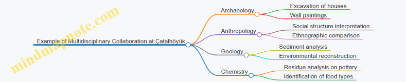
Linguistics also plays a role when inscriptions or symbols are found. For instance, deciphering the Maya script required epigraphers working closely with archaeologists to place glyphs in context. This multidisciplinary effort helped reconstruct historical events and religious beliefs.
Integrating these approaches requires clear communication and shared goals. Each discipline has its own terminology and methods, so teams must establish common ground early in the project. Data sharing platforms and joint fieldwork sessions can facilitate this.
Mind Map: Steps to Effective Multidisciplinary Integration
In practice, this integration improves the reliability of interpretations. For example, radiocarbon dating results from chemistry can be cross-checked with stratigraphic data from geology to confirm timelines. Similarly, biological analysis of plant remains can support anthropological theories about diet and agriculture.
In summary, integrating multidisciplinary approaches in archaeology turns isolated data points into a coherent narrative. It requires cooperation, respect for different expertise, and a willingness to combine diverse types of evidence. The result is a richer, more accurate understanding of ancient cultures and their environments.
15.3 Avoiding Bias and Ensuring Objectivity
Avoiding bias and ensuring objectivity are fundamental to producing reliable archaeological interpretations. Bias can creep in at any stage—from excavation to analysis to publication—and it can distort the story the evidence tells. Recognizing and mitigating bias requires deliberate strategies and constant self-awareness.
Sources of Bias in Archaeology
- Confirmation Bias: Favoring data that supports pre-existing hypotheses while ignoring contradictory evidence.
- Cultural Bias: Interpreting findings through the lens of the researcher’s own cultural background.
- Selection Bias: Excavating or analyzing only certain types of artifacts or sites, leading to skewed conclusions.
- Publication Bias: Preferring to report sensational or positive results over mundane or negative findings.
Mind Map: Types of Bias and Their Effects

Strategies to Avoid Bias
-
Use Blind Analysis When Possible: For example, when classifying pottery shards, analysts unaware of the excavation context can reduce subjective influence.
-
Employ Multiple Hypotheses: Instead of settling on a single explanation, consider alternative interpretations and test them against the data.
-
Cross-Disciplinary Collaboration: Working with experts from different backgrounds (e.g., anthropology, geology, chemistry) helps balance cultural and methodological biases.
-
Standardized Documentation: Keeping detailed, consistent records of excavation contexts and artifact conditions limits selective reporting.
-
Peer Review and Replication: Sharing data and interpretations openly invites critique and confirmation, which helps catch unnoticed biases.
Mind Map: Best Practices to Ensure Objectivity
Concrete Example: Interpreting Burial Goods
Suppose an archaeologist uncovers a burial site with various grave goods. A bias might lead them to assume the individual was wealthy because of the presence of jewelry. However, by applying multiple hypotheses, they might also consider that the goods were symbolic or communal offerings rather than personal possessions. Collaborating with cultural anthropologists familiar with similar societies can provide alternative interpretations, such as ritual significance unrelated to wealth.
Concrete Example: Site Selection Bias
Imagine a research team focusing only on large, monumental sites because they are easier to locate and more visually impressive. This selection bias might ignore smaller settlements that provide crucial information about everyday life. To counter this, the team could implement systematic surveys that include varied site sizes and types, ensuring a more representative sample.
Mind Map: Avoiding Bias in Practice
In summary, avoiding bias and maintaining objectivity is an ongoing process that requires vigilance and structured methods. It’s less about eliminating all subjectivity—which is impossible—and more about managing it so that archaeological interpretations remain as faithful as possible to the evidence.
15.4 Practical Example: Reconstructing Ancient Diets Through Isotope Analysis
Reconstructing ancient diets through isotope analysis is a practical and increasingly common approach in archaeology that provides direct evidence about what people ate, often when other sources like written records or preserved food remains are absent. This method focuses on measuring the ratios of stable isotopes—primarily carbon (C), nitrogen (N), and sometimes oxygen (O) and sulfur (S)—in human or animal bones, teeth, or other organic materials. These isotopes reflect the types of foods consumed over an individual’s lifetime.
How Isotope Analysis Works
Isotopes are atoms of the same element with different numbers of neutrons. Stable isotopes do not decay over time, making them reliable markers in archaeological samples. The key isotopes used in dietary reconstruction are:
- Carbon isotopes (¹²C and ¹³C): These help distinguish between plants using different photosynthetic pathways (C3 vs. C4 plants) and marine versus terrestrial food sources.
- Nitrogen isotopes (¹⁴N and ¹⁵N): These indicate trophic level, meaning how high an organism is in the food chain. Higher ¹⁵N values generally suggest more animal protein consumption.
Basic Mind Map: Isotope Analysis in Diet Reconstruction
Step-by-Step Example: Analyzing a Neolithic Population
Imagine an archaeological site with human skeletal remains dating to the Neolithic period. Researchers want to understand if these people relied more on farming or hunting.
- Sample Collection: Bone collagen is extracted from the femur bones of several individuals.
- Isotope Ratio Measurement: Using mass spectrometry, the ratios of ¹³C/¹²C and ¹⁵N/¹⁴N are measured.
- Interpretation:
- Carbon isotope values cluster around those typical of C3 plants, suggesting a diet based on wheat and barley rather than maize (a C4 plant).
- Nitrogen isotope values are moderately elevated, indicating some animal protein consumption but not a heavy reliance on meat.
This combination suggests a mixed diet with farming as the primary subsistence strategy supplemented by hunting or animal husbandry.
Mind Map: Interpreting Isotope Data
Example: Marine vs. Terrestrial Diets
Coastal populations often consume marine resources, which affect isotope ratios differently. Marine food chains tend to have higher ¹³C and ¹⁵N values compared to terrestrial ones. For example, a coastal Bronze Age population might show elevated ¹³C values reflecting fish consumption.
Mind Map: Marine vs. Terrestrial Diets
Practical Considerations
- Sample Preservation: Bone collagen must be well preserved; otherwise, isotope ratios may be unreliable.
- Baseline Data: Local environmental isotope baselines are necessary to interpret results accurately.
- Mixed Diets: Many ancient diets were mixed, requiring careful interpretation of overlapping isotope signals.
Concrete Example: Ancient Egyptians
Studies of Egyptian mummies show consistent ¹³C values indicative of a C3 plant diet (wheat and barley) with elevated ¹⁵N values reflecting significant consumption of animal protein, including fish from the Nile. This aligns with historical knowledge of Egyptian agriculture and fishing practices.
Summary
Isotope analysis offers a direct chemical window into ancient diets. By measuring carbon and nitrogen isotope ratios in human remains, archaeologists can distinguish between plant types, marine versus terrestrial food sources, and levels of animal protein consumption. This method complements other archaeological evidence and helps build a clearer picture of how early societies fed themselves.
The approach requires careful sampling, knowledge of local isotope baselines, and cautious interpretation, especially when diets are complex. When applied thoughtfully, isotope analysis transforms bones into detailed records of ancient eating habits.
15.5 Communicating Findings to the Public and Academia
Communicating archaeological findings effectively to both the public and academia requires clarity, accuracy, and adaptability. Archaeologists must translate complex data into narratives that are accessible without sacrificing nuance or detail. This section outlines key strategies and examples to achieve this balance.
Understanding Your Audience
The first step is recognizing the differences between academic peers and the general public. Academics expect detailed methodology, data transparency, and engagement with existing literature. The public, meanwhile, often seeks clear explanations, relevance, and engaging stories.
Mind Map: Audience Considerations

Writing for Academia
Academic communication often takes the form of journal articles, conference presentations, or technical reports. These formats demand precision and thoroughness.
Example: A report on isotope analysis used to reconstruct ancient diets will include sample sizes, lab procedures, calibration methods, and statistical analysis. It will cite previous studies and discuss how the findings fit into broader archaeological debates.
Best practice includes structuring papers with clear sections: introduction, methods, results, discussion, and conclusion. Visual aids like charts and tables should be precise and well-labeled.
Writing for the Public
When addressing a non-specialist audience, clarity and engagement are key. Avoid jargon or explain it when necessary. Use analogies or relatable examples to illustrate concepts.
Example: Instead of describing “stable isotope ratios,” say, “Scientists analyzed tiny chemical clues in ancient bones to understand what people ate.”
Storytelling can be effective but should not distort facts. Highlight why the discovery matters or how it connects to human experiences.
Mind Map: Communication Techniques
Visual Communication
Visual aids help bridge understanding. For academics, detailed site maps, stratigraphic profiles, and data graphs are standard. For the public, infographics, simplified maps, and photographs with captions are more effective.
Example: A layered diagram showing the excavation process can clarify how archaeologists uncover artifacts step-by-step.
Engaging Through Public Talks and Media
Public lectures, museum exhibits, and media interviews require a conversational tone. Prepare key messages and anticipate questions. Use analogies and avoid overwhelming listeners with technical details.
Example: In a museum talk about the Indus Valley Civilization, an archaeologist might compare the city’s drainage system to modern plumbing to illustrate its sophistication.
Mind Map: Public Engagement Channels
Transparency and Honesty
Whether speaking to peers or the public, acknowledge uncertainties and limitations. This builds trust and reflects the scientific process.
Example: When discussing the undeciphered Indus script, clarify that interpretations remain tentative and ongoing research is necessary.
Collaborative Communication
Working with educators, museum curators, and media professionals can enhance message clarity and reach. Tailoring content to different formats and audiences benefits from interdisciplinary collaboration.
Summary
Effective communication in archaeology balances detail with accessibility. Knowing your audience, using clear language, supporting points with visuals, and maintaining transparency are essential. Examples from isotope analysis reports to museum talks illustrate how these principles apply in practice.